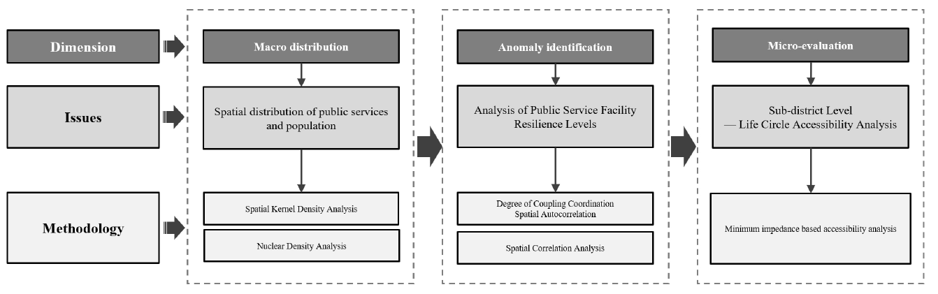
1. Introduction
In the context of rapid urbanization in China today, the configuration of public service facilities plays a decisive role in the sustainable development of cities and the welfare of residents. These facilities, including education, healthcare, elder care, cultural, and community services, are not only integral components of urban infrastructure but also crucial tools for achieving social equity and justice [
1,
2,
3]. With the acceleration of urbanization and modernization processes in China, significant progress has been made in the development and enhancement of public service facilities and their underlying infrastructure. The report from the 20th National Congress of the Communist Party of China emphasizes the principle of “people’s cities for the people” and proposes the strategic goals of building livable, resilient, and smart cities, elevating meticulous urban management to a core development agenda.
Urban resilience, defined as the capacity of cities to maintain key functions, adapt and recover quickly in the face of natural disasters, economic crises, and social unrest, has become a central topic in urban planning and governance [
4,
5]. The construction of urban resilience cannot be separated from the strong support of public service facilities, while the resilience of public service facilities is a key component of urban resilience. The rational configuration of public service facilities, particularly their accessibility and multifunctionality, is crucial for enhancing urban resilience [
6]. This configuration not only affects the daily operational efficiency of cities but also their emergency response capabilities during crises. From the economic level, a perfect public service facility system can guarantee the basic economic activities of the city during the crisis and reduce economic losses [
7]; from the perspective of urban security, reliable emergency shelter facilities and water supply and power supply facilities,
etc., can reduce the threat of disasters to the city’s security [
8]; from the level of urban governance, the enhancement of the resilience of the public service facilities can help to improve the efficiency of urban management and the ability to respond to emergencies [
9]. Therefore, optimizing the spatial layout of public service facilities is essential for strengthening the overall resilience of urban areas [
10].
As the capital of China, Beijing serves as a role model for the allocation of public service facilities. In recent years, Beijing has implemented zoning reform under the structure of “Capital Core Area + Tongzhou Sub-center + Other Regions” to balance the layout and scale of public service facilities across different districts [
11]. Similarly, cities like Shanghai and Hangzhou have set goals in their public services “14th Five-Year Plan” to enhance the equitable level of service facilities and establish 15-min community living circles. Other major cities, such as Guangzhou and Shenzhen have incorporated flexible regulations in their control plans, setting specific planning requirements for different levels and types of facilities [
12].
This paper focuses on Beijing and analyzes the optimization of public service facilities’ spatial layout to enhance urban resilience from macro and micro perspectives across city, district, and neighborhood levels. By constructing a multi-tiered spatial resilience assessment framework, the study aims to reveal the strengths and weaknesses of public service facility layouts in enhancing urban adaptability and risk resistance at various spatial scales. This research provides theoretical support and empirical evidence for urban planning and management practices, offering scientific insights to urban planners and decision-makers. It guides the integration of optimized public service facility configurations into urban development strategies to address future challenges and promote sustainable urban growth. Through the application of coupling coordination models and spatial matching theory, the paper evaluates the accessibility and multifunctionality of public service facilities and proposes strategic recommendations for strengthening urban resilience.
2. Literature Review
Research on the spatial layout and equitable distribution of public service facilities has evolved into a rich and diverse theoretical framework globally. These studies encompass both theoretical explorations and empirical analyses, focusing particularly on the accessibility and equity of facility layouts. They elucidate the dynamic interactions between public service facility configurations and the everyday lives of urban residents, becoming a focal point within urban planning research.
Internationally, the “15-min city” concept proposed by Moreno et al. (2021) [
13] has highlighted the importance of time efficiency and spatial equity in urban design. DeVerteuil’s work (2000) emphasizes the need for a balance between efficiency and equity in the siting of urban public facilities in the quantitative era [
14]. These perspectives have provided fresh insights for effective urban planning, stressing the importance of pursuing spatial accessibility and distributional equity in service facilities. Researchers like Teitz (1968) [
15] have underscored the significance of equity and efficiency in facility layout decisions through quantitative methods, which was further substantiated by researchers such as OH K, Jeong (2007) [
16], Rigolon et al. (2018) [
17], and Tan and Samsudin (2017) [
18], who employed network analysis and statistical testing. These methods have provided objective tools for assessing the spatial distribution of public service facilities.
Scholars such as Ou (2016) [
19], Garcia-Palomares et al. (2018) [
20], Dell’Ovo et al. (2018) [
21], and Tomal (2021) [
22] have focused on spatial efficiency and urban development imbalances using optimal coverage models and coupling coordination models, revealing the impacts of infrastructure and environmental dimensions on urban growth.
Domestically, the practical applications of public service facility spatial layout and accessibility in urban planning are evident. Chang et al. (2021) [
23] and colleagues have explored equity issues in the distribution of urban public services from the perspective of living circles, combining both supply and demand sides, highlighting the importance of balancing diverse resident needs during the planning process. Research teams led by Sun et al. (2017) [
24], Wu et al. (2023) [
25], Ma et al. (2016) [
26], Xu and Ye (2019) [
27] and Zhang (2021) [
28] have utilized big data sources like POI and spatial analysis methods such as GIS to study facility accessibility and spatial layout disparities, assessing the spatial compatibility of living facilities. Sun and Chai (2016) [
29] have applied empirical methods to validate the three-layer structure of community living circle systems through case studies in Qinghe Sub-district, Beijing, providing theoretical backing for the hierarchical configuration of community public services and emphasizing the influence of living circle sizes on facility accessibility. Zhou’s research [
30], by analyzing walking indices, discussed the rationality of public service facility layouts within the 15-min community living circle, underscoring the interaction between facility layouts and residential spatial structures and guiding more human-centric urban planning. Zhao et al. (2021) [
31] and others have observed that residents’ daily living circles exhibit a multicentric structure, and the accessibility of public service facilities exhibits the characteristics of a zonal structure, with its level diminishing as the distance from the center increases, displaying regional disparities among different types of public services. Wan et al. (2024) [
32] and colleagues, from both objective measurements and subjective perceptions, evaluated the coverage and convenience of health service facilities in central community living circles in Chengdu, proposing the creation of community living circles with a categorical and hierarchical system. Wu et al. (2021) [
33] and others have assessed the status of Shanghai’s 15-min community living circles, attempting to explore a replicable 15-min community planning model.
From the above studies, it can be seen that the rational layout and population allocation of public service facilities have become the core issue of urban public service provision. It can be found that existing studies are closely integrated with the practical application of urban planning, and utilize quantitative methods such as POI big data and spatial analysis to explore the fairness of urban public service facilities allocation. However, there are still some deficiencies in the existing studies. The use of homogenization standards to plan facility layouts is often mismatched with actual population demand, leading to an imbalance between resource supply and demand, which highlights the importance of research on the degree of facility-population fit. It is worth noting that most of the existing studies on the supply and demand of facilities and population are based on a single scale, which can reveal the contradiction between supply and demand, distribution characteristics and influencing factors at that scale; however, there are also limitations in this approach, for example, it fails to take into account the differences in data accuracy, processing capacity and processing speed at different scales.
Therefore, this literature review lays the groundwork for this study’s focus on the configuration relationship between public service facilities and populations, examining urban community services, cultural facilities, primary and secondary school facilities, sports facilities, medical and health facilities, and social welfare facilities as study objects. Through a combined macro and micro perspective, this paper constructs an urban public service facility resilience evaluation system, investigating the spatial coupling relationship between facility layout and population distribution at the city and district levels, identifying exceptional areas in the distribution of public service facilities, and further studying the matching relationship between different types of public service facilities and residents’ daily activity patterns at the neighborhood level. This paper aims to provide a scientific basis for the rational layout of urban public service facilities, thereby enhancing the level of urban co-construction and sharing.
3. Research Data and Methods
3.1. Study Area and Research Scope
3.1.1. Study Area
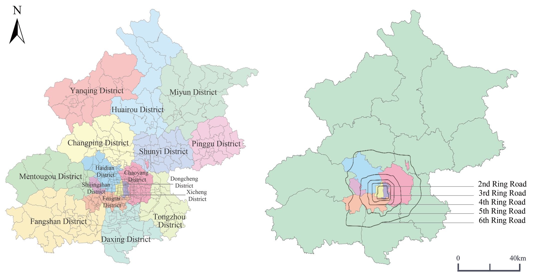
Beijing, with a total area of 16,410.54 square kilometers, is administratively divided into 16 districts, 147 sub-district units, 38 townships, and 144 towns (as illustrated in ). According to the results of the Seventh National Population Census, the permanent population of Beijing is approximately 21.893 million, with a population density of 1334 people per square kilometer. As a megacity in China, Beijing has an urbanization rate of 86% and was ranked as a global first-tier city by the Globalization and World Cities Research Network (GaWC) in 2018. A United Nations report places Beijing’s Human Development Index as the second highest among Chinese cities. Consequently, Beijing’s advanced level of urban development and the relatively successful implementation of public service facilities planning make it a particularly significant and cutting-edge case for study.
. Geographical Location of the Study Area within Beijing.
3.1.2. Research Scope
This study divides Beijing into two research levels. From a macro perspective, the citywide area of Beijing is used as the spatial boundary to analyze the spatial distribution characteristics of public service facilities, and 331 sub-districts (147 sub-districts, 38 townships, and 144 towns) are used as the basic spatial units to analyze the fitness of public service facilities and population through the coupled coordination degree model and the level of facilities per capita, and to study the spatial heterogeneity by using spatial autocorrelation analysis and combining the above. The analysis identifies regions with abnormal service supply and demand. From the micro level, the district (county) is used as the spatial boundary, and the sub-district (township, town) is used as the basic spatial unit. Based on the macro-level analysis, the sub-districts with abnormal service supply and demand are analyzed in terms of accessibility to the living area, and in this paper, the sub-district of Daitou Sub-district, Tuanjiehu Sub-district, and Xiaoguan Sub-district within Chaoyang District are selected for the spatial resilience evaluation from the micro perspective.
3.2. Data Sources
The data used in this study encompasses three primary categories: Facility distribution data for six types of public service facilities, population distribution data, and the geospatial data of Beijing’s administrative divisions and sub-district layouts. The specifics of each data source are as follows:
Facility Distribution Data: Includes the locations of urban community services, cultural facilities, primary and secondary schools, sports facilities, medical and health facilities, and social welfare facilities. This data is sourced from Baidu Maps’ Points of Interest (POI).
Population Distribution Data: Based on a 1 km × 1 km population grid for Beijing provided by Institute of Geographic Sciences and Natural Resources Research (http://www.igsnrr.cas.cn/sjgx/ accessed on 24 September 2024). This data is verified and corrected using statistics from “Beijing Seventh National Population Census Bulletin” and “Beijing Statistical Yearbook 2020” published by the Beijing Municipal Bureau of Statistics.
Administrative and Sub-district Distribution Data: Sourced from the official website of the Ministry of Natural Resources (http://bzdt.ch.mnr.gov.cn/index.html accessed on 15 August 2024) and the Beijing Municipal Commission of Planning and Natural Resources (https://ghzrzyw.beijing.gov.cn/ accessed on 15 August 2024).
In the analysis of results, the study also uses Beijing’s ring road system as a key analytical level and spatial boundary, with the specific layout of these ring roads depicted in .
. Administrative Divisions and Central Urban Area with Ring Road Layout of Beijing.
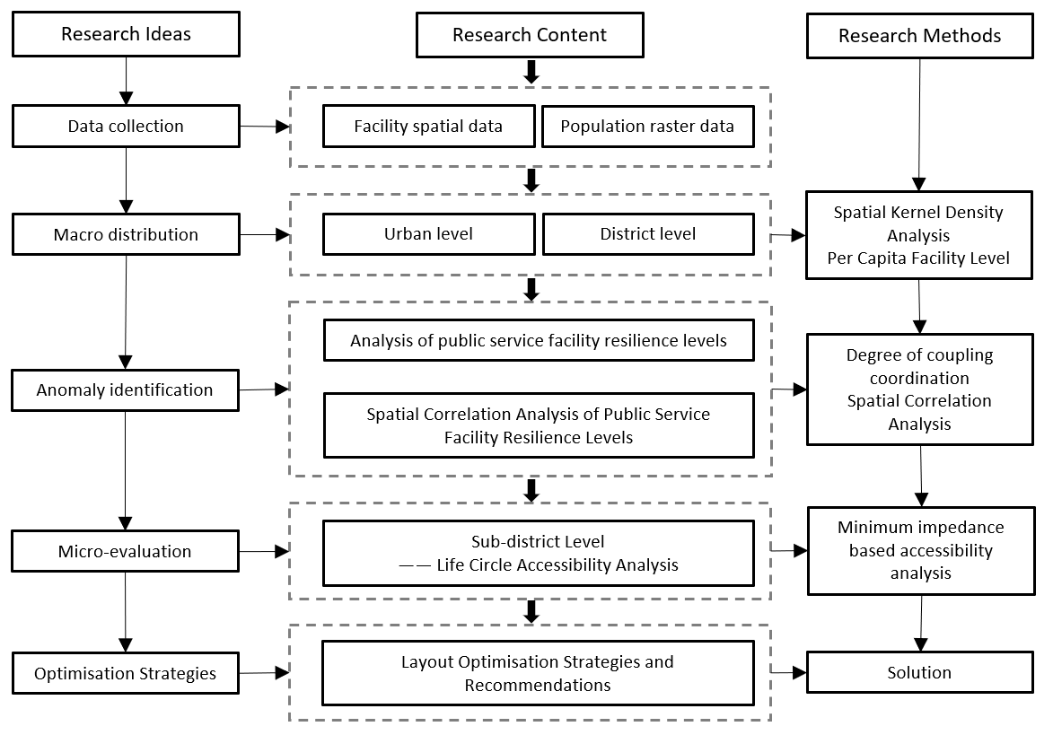
3.3.1. Technical Route
City and District Level Analysis: The article begins with an examination of public service facilities at the city and district levels, utilizing spatial matching theory and coupling coordination models. This step involves analyzing the spatial coupling between the layout of public service facilities and population distribution to identify areas where there are discrepancies between service supply and demand.
Sub-district Block Level Analysis: Building on the initial analysis, the study progresses to the sub-district block level. Here, the focus shifts to applying living circle theory and accessibility analysis models to examine the relationship between the layout of various types of public service facilities and residents’ daily activity patterns. This step aims to assess how well the facilities align with the needs and movements of the local population.
Recommendations and Planning Strategies: Finally, based on the findings from the city, district, and sub-district block level analyses, the article proposes targeted planning strategies and recommendations. These suggestions are intended to address the specific needs and issues identified through the technical analysis, ensuring that public service facilities are optimally located to serve the community effectively ().
3.3.2. Research Methods
Coupling Coordination Degree
The coupling coordination degree is a mathematical model used to address multiple interconnected tasks or decision-making issues, commonly applied to describe complex systems or processes. This model considers multiple decision variables simultaneously, where the relationships between them are interconnected, aiming to identify the optimal decision-making strategy or value scheme. In urban planning and development, the coupling coordination degree between public service facilities and the population is a quantitative indicator of the extent to which facility provision and population demand are aligned and coordinated [
34]. It involves planning and layout of various urban facilities, such as education, healthcare, and social welfare, to better meet population needs and contribute to the improvement of urban living quality and sustainable development.
For this study, a 1 km × 1 km grid is used as the research precision to calculate the coupling coordination degree between public service facilities and the population index within each grid. This measure assesses the level of coordinated development between service facilities and the population. The formula for calculating the coupling coordination degree in this paper is as follows:
In the formula,
P1 represents the population index, characterized by population density within the grid, while
P2 denotes the service facility index, represented by facility density within the grid. Both
P1 and
P2 are normalized using the extremum method to ensure values range from [0, 1]. The weights
α and
β, determined through the coefficient of variation method, indicate the relative importance of population and service facilities. In this study, both are considered equally important, hence
α =
β = 0.5.
The coupling degree
C, comprehensive evaluation index
T, and the coupling coordination degree
D all range from [0, 1]. Values closer to 1 for
C and
D indicate better coordination between urban population and facilities [
35,
36,
37,
38].
To elucidate the overall resilience of public service facilities in Beijing, this study employs the coupling coordination model across 331 sub-district units (comprising 147 sub-district units, 38 townships, and 144 towns) of Beijing to measure the adaptability level between public service facilities and the population. The results are normalized and used to establish a classification standard for the resilience levels of urban public service facilities. Liao CB (1999) [
34], in his study on the quantitative evaluation of the coordinated development of the environment and the economy, proposed a coupled coordination model and its classification criteria, and used the Pearl River Delta urban agglomeration as a case study for empirical evidence. In addition, Yin XL (2018) [
35], Pan HL (2023) [
36], and PL (2023) [
37] also validated the use of this model in their related studies. Therefore, combined with the empirical results, this paper refers to the research of Chi JM and Shi JR [
39,
40,
41] to propose the classification standard of toughness level of urban public service facilities, and adopts the Natural Breaks Classification (Jenks) to determine the toughness level classification of urban public service facilities, which is shown in .
.
Classification of Urban Public Service Facilities Resilience Levels.
| Resilience Index |
Resilience Level |
Interval |
Classification |
| [0, 0.003) |
Ⅰ |
0.000 ≤ R < 0.013 |
Low Resilience |
| [0.003, 0.013) |
Ⅱ |
| [0.013, 0.034) |
Ⅲ |
0.013 ≤ R < 0.183 |
Moderate Resilience |
| [0.034, 0.083) |
Ⅳ |
| [0.083, 0.183) |
Ⅴ |
| [0.183, 0.342) |
Ⅵ |
0.183 ≤ R < 1.000 |
High Resilience |
| [0.342, 0.555) |
Ⅶ |
| [0.555, 1.000] |
Ⅷ |
Level of Facilities Per Capita
Level of facilities per capita refers to the average level of public facilities and their services available to each person within a specific geographical area, and it is an important indicator for assessing the degree of popularization of public facilities and services [
42]. This paper compares the Level of facilities per capita based on census data and POI data of various public service facilities. The formula is as follows:
where $$R$$ is the Level of facilities per capita ratio, $$P_{1}$$ is the population index, characterized by the population density of the grid, and $$P_{2}$$ is the service facility index, characterized by the density of the facilities of the grid, which is normalized by the extreme value method, making $$P_{1}$$ and $$P_{2}$$ ∈ [0, 1]. This paper refers to the guarantee coefficient proposed in the document “Beijing Municipal Detailed Control Planning Preparation Technical Standards and Result Specifications (September 2022 Edition)” to quantitatively evaluate the Level of facilities per capita of urban public service facilities. If the result of the calculation $$R$$ > 1.3, it means that the level of facilities is high; 1.3 ≥ $$ R $$ ≥ 0.9, the level of facilities and population is considered to be comparable; if $$R$$ < 0.9, the level of facilities is considered to be low and supplementary facilities can be considered.
Spatial Autocorrelation
Spatial autocorrelation provides an intuitive geographical perspective on the spatial heterogeneity of elements, examining whether they exhibit clustering characteristics or interdependencies [
43]. This research utilizes the Global Moran’s
I and Anselin Local Moran’s
I (commonly referred to as LISA) to study the overall and localized spatial heterogeneity within the study area. The formulas for these indices are as follows:
Equation (5) provides the formula for calculating global spatial autocorrelation, and Equation (6) details the formula for local spatial autocorrelation. In these formulas,
I represents the Moran’s
I index,
n denotes the total number of elements, $$w_{i j}$$ represents the spatial weight between elements
i and
j, and$$\left(T_{i} - \overset{-}{T}\right)$$ are the deviations of attributes for elements
I and
j from their mean, respectively.
The Moran’s
I index ranges from [−1, 1]. A positive $$I$$-value ($$I > 0$$) indicates positive spatial autocorrelation. As the value approaches 1, the spatial correlation becomes increasingly pronounced. Conversely, a negative $$I$$-value ($$I < 0$$) indicates negative spatial autocorrelation, with values closer to −1 suggesting stronger spatial disparities. An $$I$$-value of zero ($$I = 0$$) indicates randomness in spatial distribution.
This paper utilizes spatial autocorrelation tools to perform exploratory analysis on the coupling coordination degree between public service facilities and population in Beijing, aiming to understand spatial patterns and inform urban planning strategies.
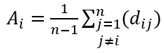
Accessibility Evaluation
Allen first introduced the accessibility analysis method based on minimal impedance in 1995, which uses the average minimal impedance from a central point to all destination points as a measure of accessibility for that central point [
44]. On a micro level, this method allows for the precise calculation of the minimal impedance (such as time or distance) from specific facilities or locations to other places, thus accurately reflecting the accessibility level of these facilities or locations. Such precision is crucial for assessing the convenience of transportation and the accessibility of service within a small area. Therefore, this study employs the minimal impedance-based method to measure the accessibility at the living circle level for sub-district analysis.
In this research, the centroids of population grids are used as origin points, and the locations of various facilities serve as destination points. The average spatial travel distance on the transportation network from each origin point to destination points within the living circle is calculated and used as an accessibility evaluation index. The smaller the calculated distance, the better the accessibility of that type of facility. The formulas are as follows:
Here, $$A_{i}$$ represents the accessibility of node $$i$$ on the network, $$A$$ represents the overall network accessibility, and $$d_{i j}$$ denotes the minimal impedance between nodes $$i $$ and $$j$$, which in this study is the shortest spatial distance.
4. Results and Discussion
4.1. Analysis of Spatial Distribution Characteristics of Public Service Facilities
4.1.1. Spatial Kernel Density Analysis
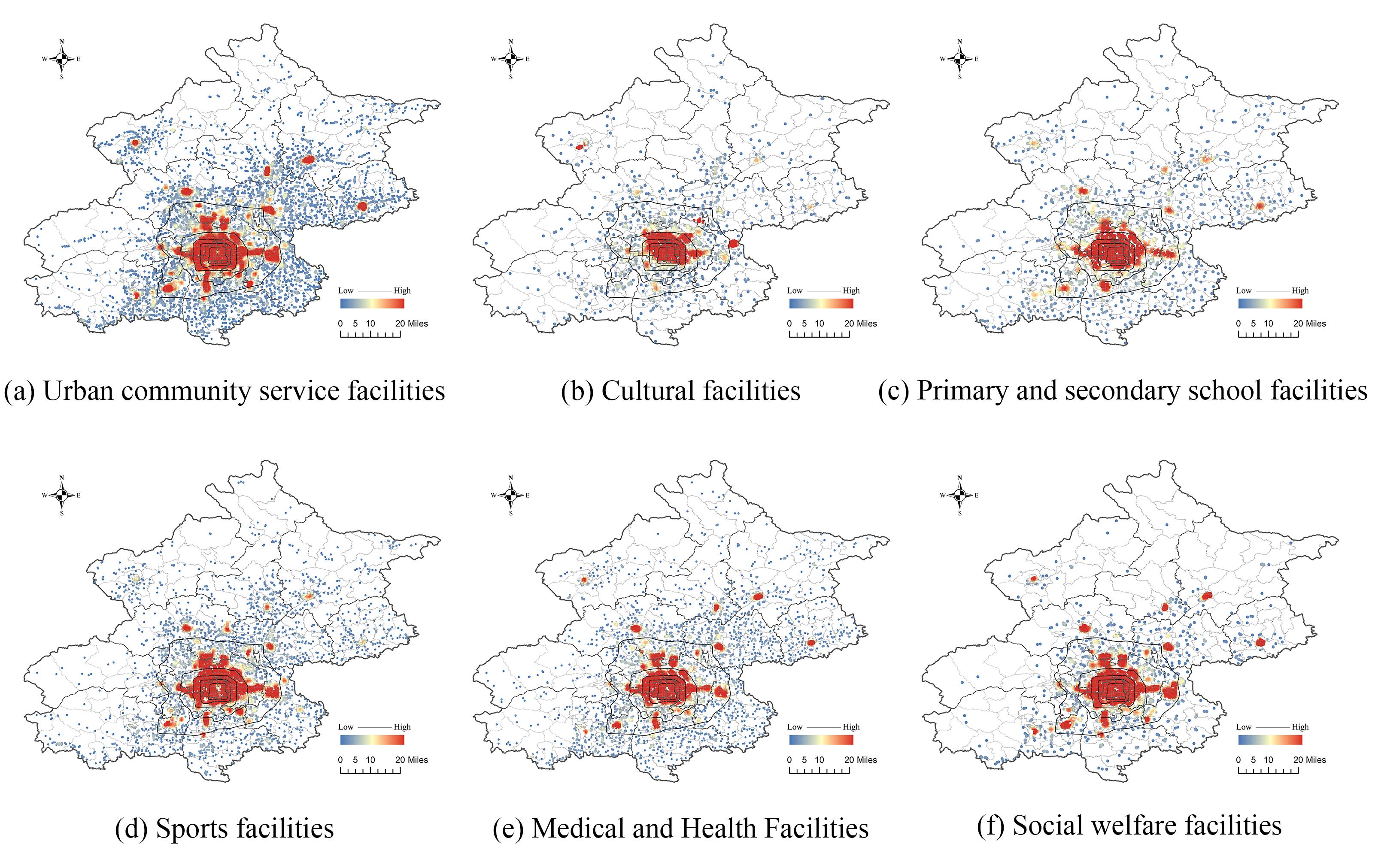
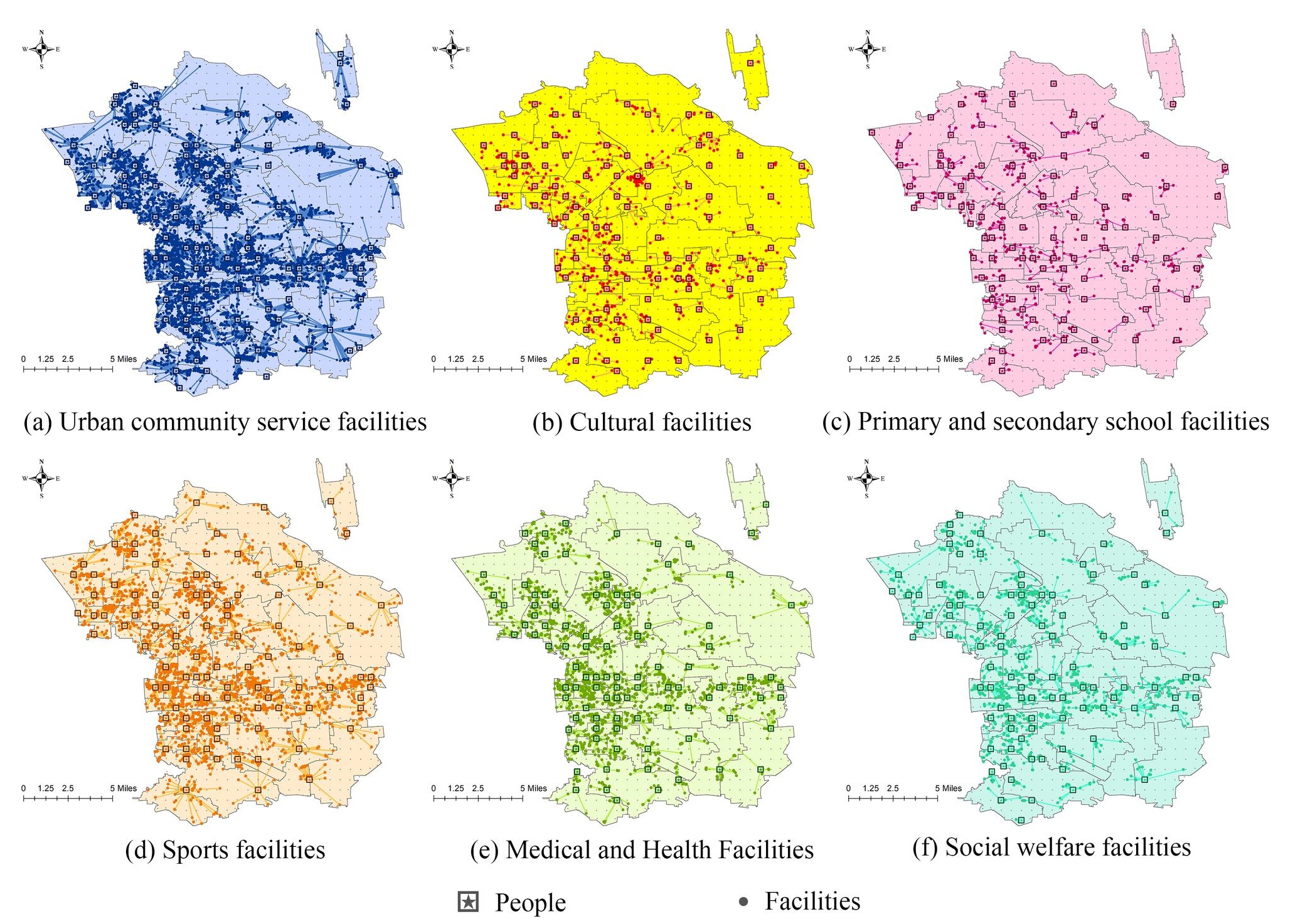
This study conducts a kernel density analysis on point of interest (POI) data for six categories of public service facilities in Beijing: urban community services, cultural facilities, primary and secondary schools, sports facilities, medical and health facilities, and social welfare facilities. The kernel density calculation of these point features is used to illustrate the spatial distribution characteristics of public service facilities.
From the kernel density analysis (as shown in ) and relevant statistical data, it can be observed that the distribution of the six types of public service facilities analyzed in this study is primarily concentrated in the regions located within Beijing’s Sixth Ring Road, which corresponds to the central urban districts (including Dongcheng, Xicheng, Chaoyang, Haidian, Fengtai, and Shijingshan). The number of facilities shows a clear distance-decay pattern, with the highest density in the city center, gradually decreasing toward the outskirts (demonstrating a zonal distribution pattern). In suburban districts such as Miyun, Pinggu, Changping, Shunyi, and Yanqing, the facilities exhibit a scattered, clustered distribution.
Public service facilities in Beijing are heavily concentrated in the central urban districts, with the near suburbs (including Daxing, Tongzhou, Shunyi, Changping, Mentougou, and Fangshan) having a moderate share, and the distant suburban districts (including Huairou, Pinggu, Miyun, and Yanqing) having a relatively lower share. This spatial distribution pattern aligns with the general development trends of major cities in China. The central urban area has experienced earlier development, resulting in a more established network of facilities in this area. Consequently, the distribution of facilities exhibits a pattern of central concentration and a stepwise reduction outward.
. The kernel density analysis of six types of public service facilities in Beijing.
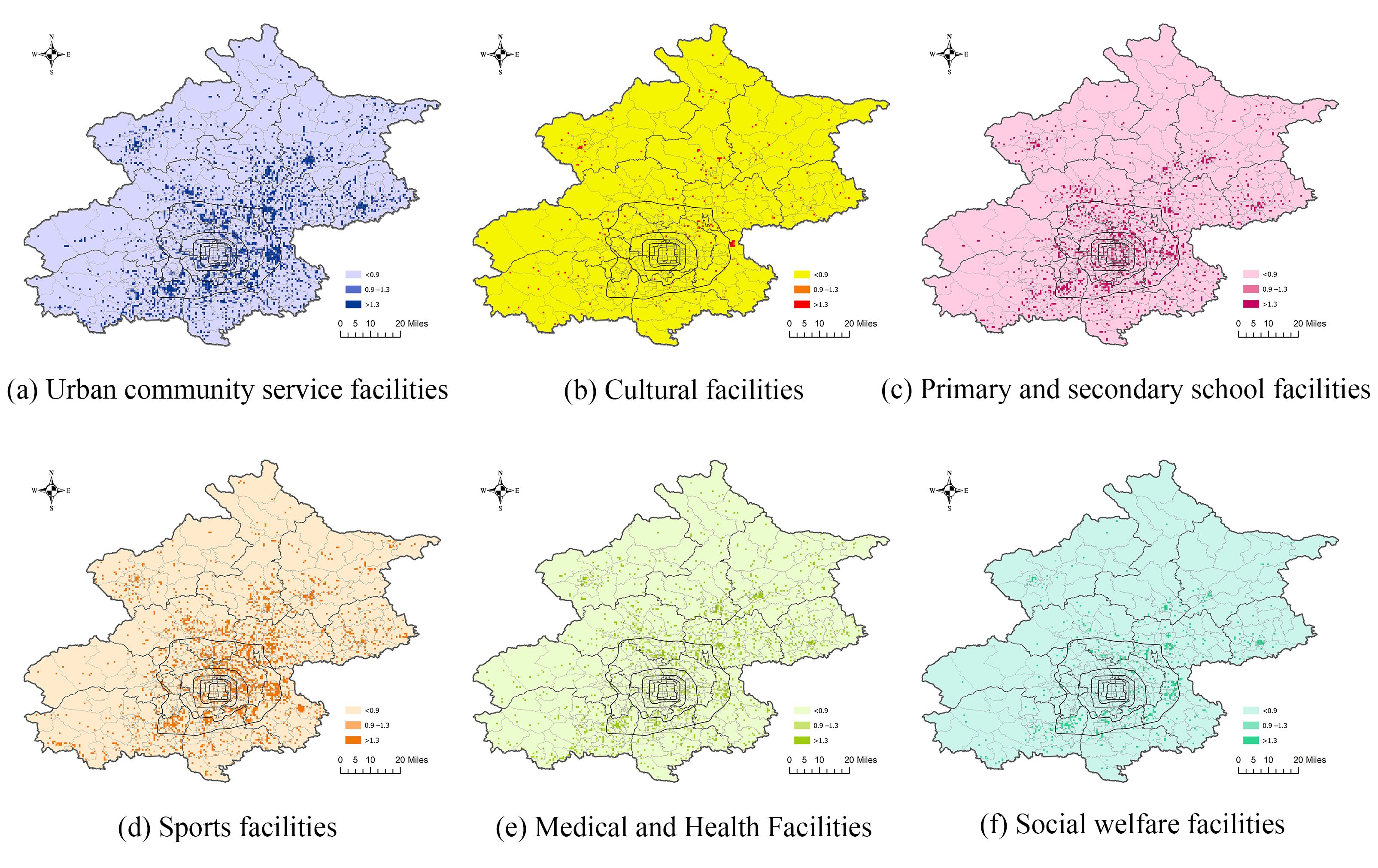
4.1.2. Analysis of Per Capita Facility Levels
In the analysis of per capita facility levels across the entire Beijing region, no significant clustering of facilities in the central urban districts is observed (see ). Rankings of per capita facility levels for the six types of facilities across districts (see ) reveal that the top three districts are all located outside of Beijing’s central urban area. Notably, Pinggu District ranks highest in terms of per capita urban community services, sports facilities, and medical and health facilities. Both Pinggu and Shunyi districts rank in the top three for per capita levels of five types of facilities, showing that urban community services, sports facilities, and medical and health facilities in these districts have reached a level commensurate with the population size.
In contrast, the regions ranking lower in per capita facility levels are primarily located in central urban districts such as Dongcheng, Xicheng, and Haidian. The measured values of per capita facility levels in these areas indicate that the availability of facilities does not meet the population’s needs, and the number of facilities needs to be significantly increased.
It is noteworthy that the level of facilities per capita of the six types of public service facilities in the central urban area of Beijing is not higher than 1.3, which has not yet reached a high level; at the same time, the rankings of various types of facilities of the six districts of the city are not in a very high position in the whole area of Beijing. Among the six administrative districts in the central city of Beijing, the Level of facilities per capita of public service facilities in Chaoyang District is relatively outstanding, which is shown by the fact that the per capita facility levels of urban community service facilities, cultural facilities, sports facilities, medical and health care facilities, and social welfare facilities in Chaoyang District are the highest among the six districts in the city of Beijing, and the highest per capita level of primary and middle school facilities in the central city of Beijing is found in the Dongcheng District area.
Additionally, the per capita levels of cultural and social welfare facilities in all districts fall below 0.9, indicating that none of these districts have reached a level where the availability of these facilities is proportional to the population size. This highlights a gap in the provision of these types of facilities across the city.
. Characterization of per capita facility level of public service facilities in Beijing.
.
Analysis of Per Capita Public Service Facilities Levels by District in Beijing.
| Region |
Urban Community Service Facilities |
Cultural Facilities |
Primary and Secondary School Facilities |
Sports Facilities |
Medical and Health Facilities |
Social Welfare Facilities |
| Per capita level of facilities |
Value |
Rank |
Value |
Rank |
Value |
Rank |
Value |
Rank |
Value |
Rank |
Value |
Rank |
| Six Districts of the Central City |
Dongcheng District |
0.61 |
14 |
0.1 |
6 |
0.81 |
6 |
0.47 |
15 |
0.4 |
12 |
0.16 |
12 |
| Xicheng District |
0.49 |
15 |
0.07 |
10 |
0.64 |
10 |
0.44 |
16 |
0.36 |
13 |
0.17 |
10 |
| Chaoyang District |
1.04 |
7 |
0.11 |
4 |
0.67 |
9 |
1.22 |
7 |
0.47 |
7 |
0.3 |
4 |
| Haidian District |
0.46 |
16 |
0.08 |
9 |
0.52 |
12 |
0.67 |
12 |
0.31 |
15 |
0.17 |
11 |
| Fengtai District |
0.72 |
12 |
0.05 |
12 |
0.56 |
11 |
0.53 |
14 |
0.32 |
14 |
0.26 |
6 |
| Shijingshan District |
0.64 |
13 |
0.05 |
13 |
0.48 |
13 |
0.61 |
13 |
0.28 |
16 |
0.15 |
13 |
| Suburbs |
Daxing District |
1.04 |
6 |
0.05 |
11 |
0.95 |
4 |
0.94 |
10 |
0.43 |
10 |
0.25 |
7 |
| Tongzhou District |
1.75 |
4 |
0.09 |
7 |
0.88 |
5 |
1.44 |
5 |
0.59 |
5 |
0.41 |
1 |
| Shunyi District |
1.79 |
3 |
0.13 |
3 |
1.93 |
3 |
1.56 |
4 |
0.75 |
3 |
0.31 |
3 |
| Changping District |
0.92 |
8 |
0.04 |
15 |
0.48 |
14 |
1.73 |
3 |
1.05 |
2 |
0.31 |
2 |
| Fangshan District |
0.84 |
10 |
0.1 |
5 |
0.72 |
7 |
1.17 |
8 |
0.42 |
11 |
0.19 |
9 |
| Mentougou Distric |
0.84 |
9 |
0.04 |
16 |
4.62 |
1 |
0.9 |
11 |
0.59 |
6 |
0.13 |
15 |
| Remote Suburbs |
Huairou District |
1.99 |
2 |
0.08 |
8 |
0.39 |
16 |
3.15 |
2 |
0.65 |
4 |
0.13 |
14 |
| Pinggu District |
2.57 |
1 |
0.19 |
2 |
2.67 |
2 |
3.28 |
1 |
2 |
1 |
0.29 |
5 |
| Miyun District |
1.35 |
5 |
0.04 |
14 |
0.42 |
15 |
1.4 |
6 |
0.45 |
8 |
0.24 |
8 |
| Yanqing District |
0.81 |
11 |
0.27 |
1 |
0.68 |
8 |
1.06 |
9 |
0.43 |
9 |
0.11 |
16 |
4.2. Evaluation of Spatial Resilience from a Macro Perspective—Identification of Anomalous Areas
4.2.1. Analysis of Public Service Facility Resilience Levels
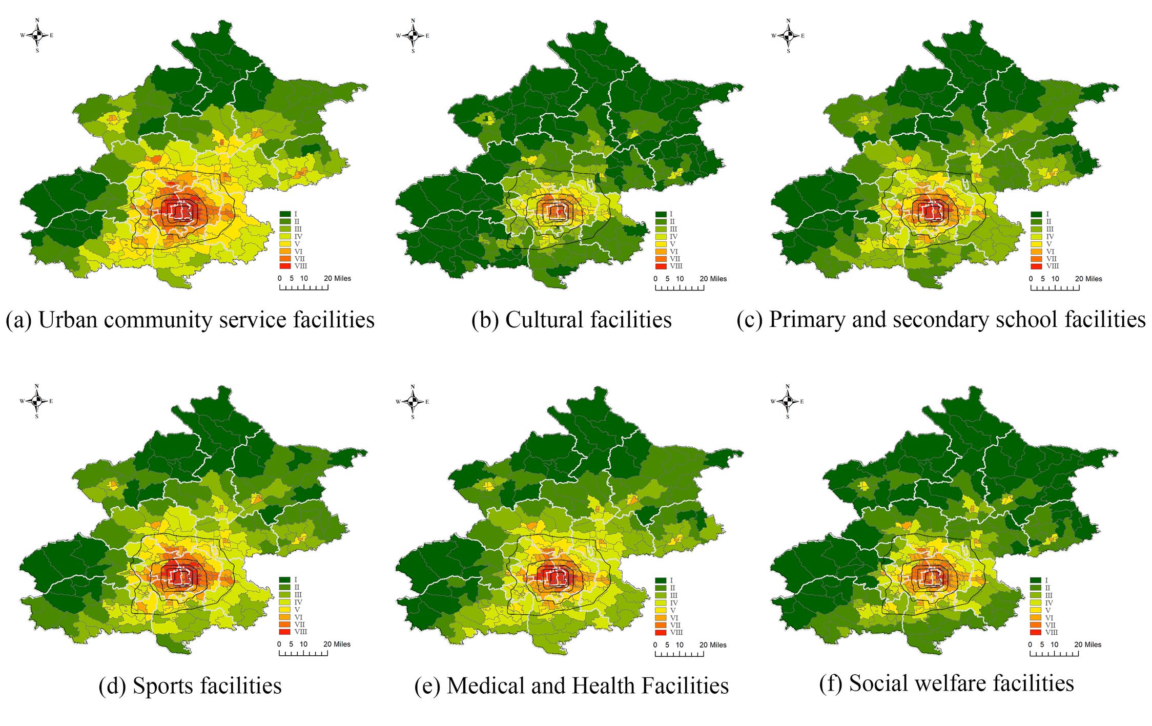
Using sub-district blocks as the spatial analysis units, this study calculates the coupling coordination degree between public service facilities and the population across the entire area of Beijing, followed by data normalization to derive an index of urban public service facility resilience.
Spatial Distribution Analysis (as illustrated in ): The coupling coordination degree between the six types of facilities and the population generally shows consistency in spatial characteristics. Specifically, there is an overall trend of decreasing resilience from the city center towards the periphery. Sub-districts with a resilience level of Grade V and above are primarily clustered within the Fifth Ring Road, predominantly in the districts of Dongcheng, Xicheng, and Chaoyang. Urban community services, primary and secondary school facilities, sports facilities, and medical and health facilities exhibit relatively high resilience levels, while social welfare and cultural facilities show relatively lower levels.
District-level Analysis (as shown in ): The average resilience ranking of the six types of public service facilities across Beijing, from highest to lowest, is: Urban community service facilities, sports facilities, medical and health facilities, primary and secondary schools, social welfare facilities, and cultural facilities. Social welfare and cultural facilities in the city districts achieve a moderate level of resilience, while urban community services, sports facilities, medical facilities, and schools reach high resilience levels.
.
Resilience Index of Public Service Facilities by District in Beijing.
| Region |
Urban Community Service Facilities |
Cultural Facilities |
Primary and Secondary School Facilities |
Sports Facilities |
Medical and Health Facilities |
Social Welfare Facilities |
| Changping District |
0.201 |
0.032 |
0.174 |
0.141 |
0.105 |
0.081 |
| Chaoyang District |
0.545 |
0.233 |
0.535 |
0.437 |
0.358 |
0.371 |
| Daxing District |
0.152 |
0.027 |
0.101 |
0.091 |
0.067 |
0.071 |
| Dongcheng District |
0.780 |
0.466 |
0.661 |
0.686 |
0.489 |
0.799 |
| Fangshan District |
0.073 |
0.009 |
0.040 |
0.041 |
0.027 |
0.032 |
| Fengtai District |
0.416 |
0.088 |
0.318 |
0.253 |
0.228 |
0.247 |
| Haidian District |
0.453 |
0.204 |
0.444 |
0.379 |
0.280 |
0.326 |
| Huairou District |
0.078 |
0.017 |
0.051 |
0.050 |
0.036 |
0.037 |
| Mentougou District |
0.072 |
0.013 |
0.045 |
0.042 |
0.040 |
0.050 |
| Miyun District |
0.061 |
0.007 |
0.037 |
0.039 |
0.022 |
0.022 |
| Pinggu District |
0.083 |
0.014 |
0.039 |
0.044 |
0.032 |
0.038 |
| Shijingshan District |
0.349 |
0.096 |
0.294 |
0.243 |
0.164 |
0.224 |
| Shunyi District |
0.121 |
0.018 |
0.082 |
0.074 |
0.046 |
0.042 |
| Tongzhou District |
0.206 |
0.038 |
0.164 |
0.123 |
0.104 |
0.101 |
| Xicheng District |
0.763 |
0.418 |
0.707 |
0.685 |
0.512 |
0.759 |
| Yanqing District |
0.049 |
0.010 |
0.026 |
0.026 |
0.017 |
0.019 |
| City Area |
0.287 |
0.110 |
0.203 |
0.248 |
0.219 |
0.168 |
Analysis by 331 Sub-district Blocks: There are 72 sub-district blocks where all six types of facilities reach high resilience levels, mainly distributed in Dongcheng, Xicheng, Chaoyang, and Haidian districts, among which 44 sub-districts, such as Andingmen, Shichahai, and Hepingjie, have at least four types of facilities reaching Grade VIII resilience level whereas Chaoyangmen and Jianguomen sub-districts in Dongcheng District and Dashilar sub-district in Xicheng District exhibit the highest resilience levels for all six types of facilities.
A few sub-district blocks between the Fifth and Sixth Ring Road such as Longze Garden in Changping District and Luying in Changping District, reach high resilience levels for some facilities. Some facilities in sub-districts surrounding the Sixth Ring achieve moderate resilience levels, while most sub-districts extending towards the city outskirts exhibit low resilience levels. However, sub-districts outside the Sixth Ring in districts like Yanqing (Xiangshuiyuan and Rulin), Huairou (Quanhe and Longshan), Miyun (Gulou and Guoyuan), and Pinggu (Binhe, Xinggu, and Pinggu Town), have at least one type of facility reaching a high level of resilience.
Most sub-district blocks outside the Six Ring exhibit moderate to low resilience levels. A total of 24 sub-district blocks have a cultural infrastructure resilience index approaching zero such as Liu Binbao Township, Fengjiayu Town, Da’anshan Township, Jiudu River Town, Xiagezhuang Town, and Zhang Town. 30 sub-district blocks have a cultural social welfare resilience index close to zero, including Longwantun Township, Junzhuang Township, Jinhaihu Township and Bohai Township. The sub-district blocks mentioned above are mostly located in Fengtai District, Yanqing District, Shunyi District, Fangshan District, Huairou District, Miyun District, and Daxing District indicating a significant mismatch between facility provision and population needs in these areas.
. Analysis of Coupling Coordination Characteristics Between Public Service Facilities and Population in Beijing.
Comparative Analysis across Six Types of Facilities: Urban community service facilities have the highest resilience levels, while cultural facilities rank the lowest. Cultural facilities are predominantly concentrated in the central urban areas of Dongcheng and Xicheng districts, such as Qianmen Sub-district and Chaoyangmen Sub-district, with these districts housing about 14% of the city’s cultural facilities, representing approximately 24% of the central urban area.
By integrating the resilience index with per capita facility level, the extent to which public service facilities align with population needs can be evaluated. When both indicators show good performance, it indicates that facilities and population are well-matched. According to the analysis results, Tongzhou District ranks in the top 50% citywide for both the resilience index and the per capita facility level across all six types of facilities. In Chaoyang District, five types of facilities (excluding basic education) rank in the top 50%. Dongcheng District ranks in the top 50% for cultural and basic education facilities, while Haidian District’s cultural facilities and Changping District’s urban community service facilities also rank in the top 50%.
Looking at the 133 sub-district units, only three sub-districts rank in the top 100 for both the resilience index and per capita facility level across all six types of facilities: Balizhuang, Wangjing, and Donghu Sub-districts in Chaoyang District. In Shuangjing Sub-district of Chaoyang District, five facilities (excluding basic education) rank in the top 100, and in Zhongcang and Beiyuan Sub-districts of Tongzhou District, five types of facilities (excluding cultural facilities) rank in the top 100.
The resilience level of Beijing’s six public service facility types generally decreases from the city center outward, but most areas in the city have a per capita facility level below 0.9, particularly within the central districts. This suggests a persistent misalignment between public service facilities and population. Although the central urban area contains a large number of public facilities, it also accommodates a high population density, resulting in a lower per capita facility level compared to peripheral areas.
However, outside the central districts, a few sub-districts perform well on both indicators, such as Guangming Sub-district, Shiyuan Sub-district, and Konggang Sub-district in Shunyi District, Binhe Sub-district in Pinggu District, Gulou and Guoyuan Sub-districts in Miyun District, and Quanhe Sub-district in Huairou District. This shows that some peripheral areas are successfully balancing facility provision and population needs.
4.2.2. Spatial Correlation Analysis of Public Service Facility Resilience Levels
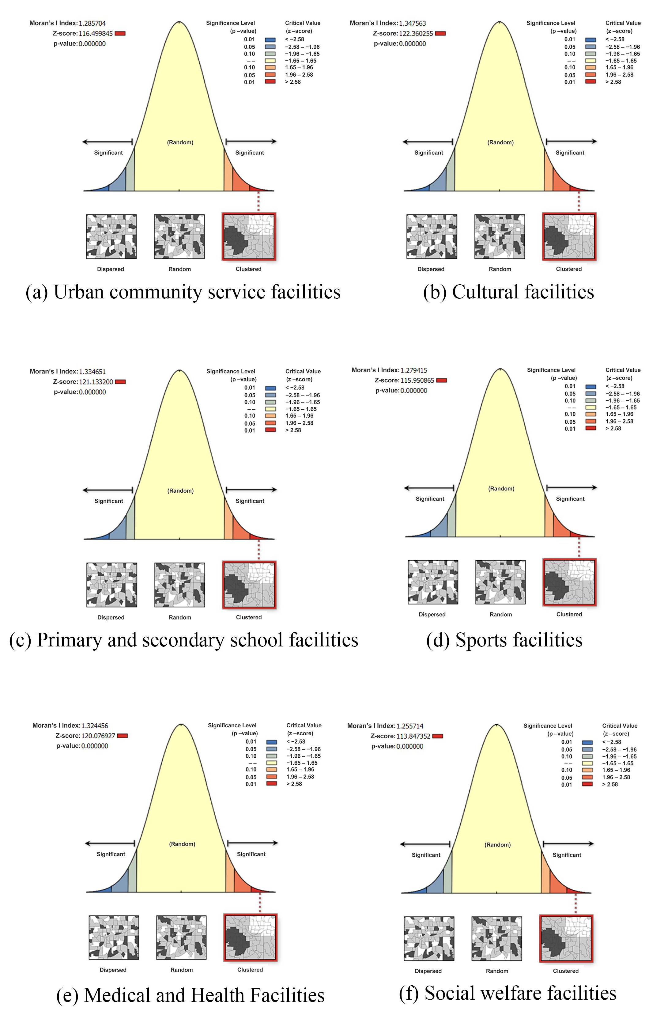
The Moran’s
I autocorrelation analysis was conducted by analyzing the resilience index of urban public service facilities in Beijing. According to the results ( and ), the global Moran’s
I index of Beijing urban public service facilities resilience index ranges from 0.54 to 0.63, with a Z-score of >2.58 and
p-value < 0.01. According to the common practice in academic research and practice, the scores are statistically significant, and therefore it is considered that the Beijing urban public service facilities resilience index has spatial correlation. Moreover, the positive Moran’s
I indices suggest that the resilience for urban public service facilities exhibits positive spatial correlation, meaning that these elements are spatially clustered.
.
Global Moran’s I of Resilience Index of Urban Public Service Facilities in Beijing City.
| Facilities Category |
Moran’s I Index |
Z-Score |
p-Value |
| Urban Community Service Facilities |
0.584405 |
17.662870 |
0.000000 |
| Cultural Facilities |
0.550503 |
16.652795 |
0.000000 |
| Primary and Secondary School Facilities |
0.542118 |
16.383362 |
0.000000 |
| Sports Facilities |
0.631058 |
19.054504 |
0.000000 |
| Medical and Health Facilities |
0.607415 |
18.3428311 |
0.000000 |
| Social Welfare Facilities |
0.615302 |
18.586817 |
0.000000 |
Further analysis of the six types of public service facilities reveals that the spatial correlation of sports facilities is the strongest, indicating the most coordinated spatial relationship between these facilities and population distribution. On the other hand, primary and secondary school facilities display the weakest spatial correlation among the six types of public services, suggesting a less cohesive spatial distribution in relation to the population.
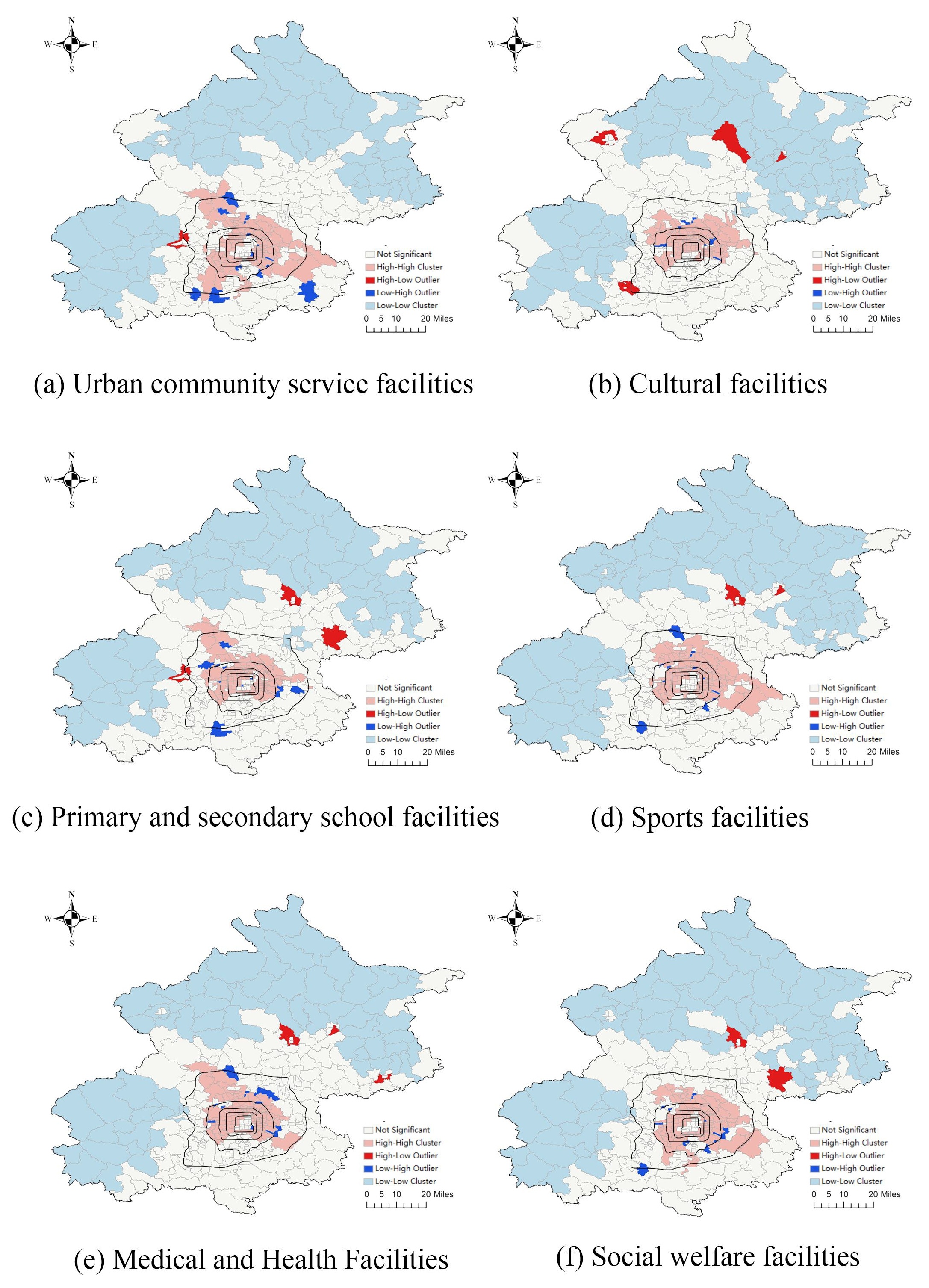
The application of the LISA (Local Indicators of Spatial Association) statistic reveals the spatial heterogeneity of the resilience index for urban public service facilities in Beijing. The city’s sub-district units can be broadly classified into four categories: “High-High”, “High-Low”, “Low-High”, and “Low-Low” ().
The “High-High” and “Low-Low” types represent areas of local positive spatial correlation. The “High-High” type refers to high clustering values, where the resilience index for urban public service facilities is high both in the unit and in its neighboring units. The “Low-Low” type represents low clustering values, indicating that the resilience index is low in both the unit and its neighboring units [
45,
46].
The “High-Low” and “Low-High” types represent areas of local negative spatial correlation. The “High-Low” type indicates that the resilience index for urban public service facilities within the unit is significantly higher than in its neighboring units, while the “Low-High” type indicates that the unit’s resilience index is significantly lower than that of its neighbors. In this study, the “High-Low” and “Low-High” areas are identified as outlier regions where the resilience index for urban public service facilities demand is anomalous, signaling areas that may require targeted interventions to improve the alignment of public service facilities with population needs.
The “High-High” type represents areas with high clustering values, indicating both high population density and a high density of public service facilities. These areas are mainly concentrated in the central urban districts of Beijing, which has experienced prolonged development, characterized by a concentrated population and relatively well-established supporting facilities.
On the other hand, “Low-Low” areas show low population density and a low density of facilities, but the balance between the two is relatively harmonious. These areas are primarily located on the outskirts of Beijing, including Yanqing, Huairou, Miyun, Pinggu, Mentougou, and Fangshan districts.
“High-Low” areas, where the resilience index for urban public service facilities is significantly higher than that of surrounding sub-districts, are found in several key locations: Yanqi Town in Huairou District, Yancun Town in Fangshan District, Yanqing Town in Yanqing District, and Gulou Sub-district in Miyun District, where the resilience index for cultural facilities is notably higher than in nearby areas.
Additional “High-Low” examples include: Longquan Town in Mentougou District, where urban community services and primary/secondary school facilities show a higher resilience index than those of surrounding sub-districts, Gulou Sub-district in Miyun District, which excels in sports and healthcare facilities, Huairou Town in Huairou District, where primary/secondary schools, sports facilities, healthcare, and social welfare facilities stand out, Yang Town in Shunyi District, which shows higher resilience for primary/secondary schools and social welfare facilities.
The “Low-High” areas are typically found on the outskirts of the “High-High” clusters. In these areas, facility resilience is lower than in adjacent sub-districts. Examples include: Daitou Sub-district in Chaoyang District, where all facilities except for primary/secondary schools exhibit lower resilience index than surrounding units, Tuanjiehu Sub-district in Chaoyang District, where urban community services, cultural facilities, sports facilities, and social welfare facilities show lower resilience, Xiaoguan Sub-district in Chaoyang District, where the resilience of urban community services and sports facilities is below that of surrounding areas.
In Haidian District, Tiancunlu Sub-district and Dongsheng Town show lower resilience for cultural facilities, while Haidian Town exhibits lower resilience for primary/secondary schools, sports, healthcare, and social welfare facilities. Similarly, in Changping District, Tiantongyuan South Sub-district shows significantly lower resilience across urban community services, cultural facilities, sports, healthcare, and social welfare facilities compared to neighboring areas.
. Global Spatial Autocorrelation Analysis of Resilience Index of Urban Public Service Facilities in Beijing.
. Local Spatial Autocorrelation Analysis of the Coupling Coordination Degree of Public Service Facilities in Beijing.
4.2.3. Identification of Anomalous Areas
The combined resilience index and per capita level of facilities can reflect to some extent the suitability of facilities for the population, and when both the resilience index and the per capita level of facilities perform well, it means that the facilities and the population have achieved adequate suitability. Considering that the calculation results of the above two indicators are different in terms of scale and unit, direct comparison of the values lacks scientific validity, so this study adopts the ranking comparison method. Specifically, the ranking of each type of facility in each sub-district is selected as the basis for analysis. If the ranking of a type of facility in a sub-district under both indicators exceeds the ranking of the city’s up to 50% of the sub-districts, it is considered that this type of facility in the sub-district is adequately adapted to the population.
From the results of the analysis, Tongzhou District ranks in the top 50% of the city in terms of both the resilience index and the level of facilities per capita in all six categories of facilities, Chaoyang District ranks in the top 50% of the city in all five categories of facilities except basic education facilities, Dongcheng District ranks in the top 50% of the city in terms of facilities in the categories of culture and basic education, and Haidian District ranks in the top 50% of the city in terms of cultural facilities and Changping District in terms of community service facilities in the towns and cities. Looking at the 331 sub-districts, there are only three sub-districts that are in the top 100 for both the resilience index and the per capita level of facilities in all six categories, namely, Baliizhuang Sub-district, Wangjing Sub-district and Donghu Sub-district in Chaoyang District. Shuangjing Sub-district in Chaoyang District ranked in the top 100 in terms of resilience index and per capita facility level for the remaining five categories of facilities, except for basic education facilities; Zhongcang Sub-district and Beiyuan Sub-district in Tongzhou District ranked in the top 100 for the remaining five categories of facilities, except for cultural facilities.
The level of resilience of the six types of public service facilities in Beijing shows a decreasing trend from the city centre to the outer circles, but the per capita level of facilities in most of the areas within the city is lower than 0.9, especially in the central urban area, which indicates that there is still a problem in matching the public service facilities with the population. Considering that the central urban area has a large concentration of public facilities but also a large population, its per capita facility level is rather lower than that of the peripheral areas. Meanwhile, outside the central city, there are a small number of sub-districts that perform better on both indicators, such as Guangming Sub-district, Shiyuan Sub-district and Konggang Sub-district in Shunyi District, Binhe Sub-district in Pinggu District, Gulou Sub-district and Orchard Sub-district in Miyun District, and Quanhe Sub-district in Huairou District.
According to Section 4.2.2 the spatial autocorrelation analysis of Beijing’s urban public service facilities resilience index, it can be seen that Beijing’s facilities resilience index exhibits positive spatial correlation and a clustered state; and among the four types of sub-district units that represent local spatial heterogeneity, ‘high-high’ sub-districts are mainly clustered in the central urban area, while ‘low-high’ sub-districts are mostly found at the periphery of ‘high-high’ concentration areas, such as Daitou Sub-district in Chaoyang District. The ‘low-high’ neighborhoods are mostly found in the periphery of the ‘high-high’ concentration areas, such as the Daitou Sub-district in Chaoyang District, while the ‘high-low’ neighborhoods are mostly outside the fifth ring road of the city, basically in the area of the fifth ring road of the city. The ‘low-low’ type sub-districts are mostly outside the fifth ring road of the city, basically in the outer part of the ‘low-low’ type near the city centre, such as Yanqi Town in Huairou District, Yancun Town in Fangshan District, and Yanqing Town in Yanqing District. Among them, the ‘high-low’ and ‘low-high’ types of sub-district neighborhoods, which show local negative correlation, are the areas identified in this study as showing abnormalities in service supply and demand, and therefore, the matching relationship between the layout of public service facilities and the residents’ daily activity patterns is mainly explored at the micro level for those types of areas. Therefore, the relationship between the layout of public service facilities and the daily activity patterns of residents is further investigated at the micro level in order to pinpoint the key areas of over- or under-servicing.
4.3. Micro-Level Spatial Resilience Evaluation—Accessibility Analysis of Living Circles
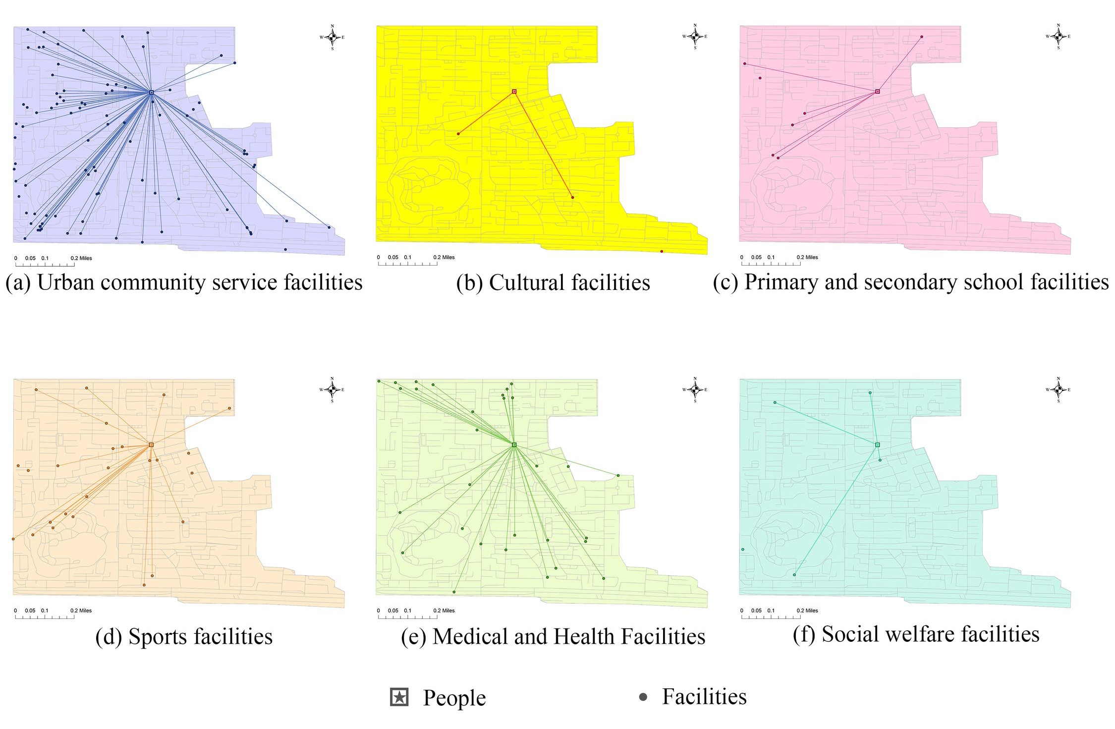
Building on the previous analysis of public service facility spatial configurations at the city and district levels, this section delves into a micro-level evaluation of sub-district blocks where anomalies in public service facility resilience levels were identified. Using ArcGIS’s network analysis module, Allen’s minimal impedance accessibility method was applied to assess the accessibility of public service facilities. This method calculates the average impedance (such as distance or travel time) from population grid centroids to all destination points within a defined radius, serving as the evaluation metric for facility accessibility at the sub-district level.
Chaoyang District, located in the central-southern part of Beijing, is the largest and most populous central urban district. It comprises 24 sub-district units and leads the city in the number of facilities across all six categories of public services. According to the local spatial autocorrelation analysis of public service facility resilience, several sub-districts in Chaoyang District have lower resilience levels compared to their neighboring areas. For example, Fengtai Sub-district has lower resilience in all facilities except primary and secondary schools, Tuanjiehu Sub-district shows lower resilience in urban community services, cultural facilities, sports facilities, and social welfare services, and Xiaoguan Sub-district has lower resilience in urban community services and sports facilities. Therefore, Chaoyang District, along with the three anomalous sub-districts of Fengtai, Tuanjiehu, and Xiaoguan, was selected for a detailed accessibility analysis at the living circle scale.
According to the results of the minimal impedance accessibility evaluation (see and , , and ), the average accessibility distance for residents in Chaoyang District to public service facilities is 868 m. Cultural facilities, primary and secondary schools, medical and health facilities, and social welfare services have accessibility levels above the district average at the sub-district level. In contrast, urban community services and sports facilities are less accessible, with residents needing to walk farther to reach these services compared to the other four categories.
.
The accessibility analysis of public service facilities in anomalous sub-districts of Chaoyang District.
| Unit (/m) |
Urban Community Service Facilities |
Cultural Facilities |
Primary and Secondary School Facilities |
Sports Facilities |
Medical and Health Facilities |
Social Welfare Facilities |
Average Accessibility |
| Daitou Neighborhoodt |
663 |
2755 |
559 |
927 |
738 |
1865 |
1251 |
| Tuanjiehu Neighborhood |
766 |
717 |
691 |
655 |
690 |
530 |
675 |
| Xiaoguan Neighborhood |
587 |
681 |
497 |
581 |
568 |
568 |
580 |
| Chaoyang District |
993 |
758 |
765 |
978 |
852 |
861 |
868 |
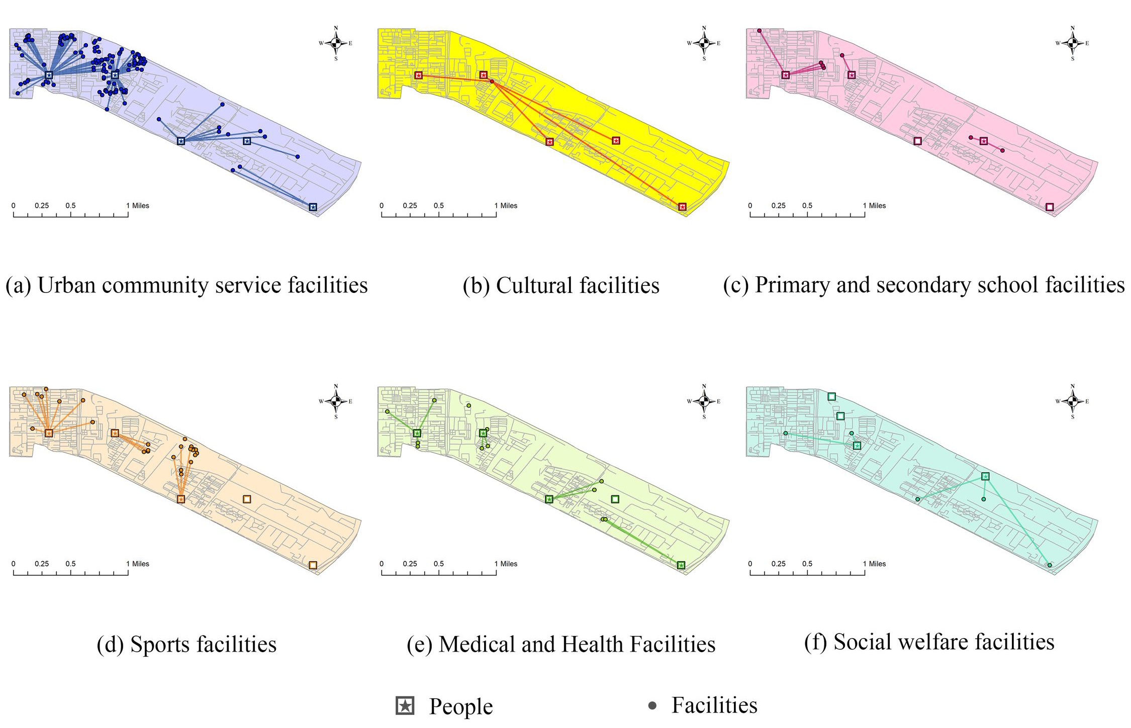
. The accessibility analysis of public service facilities in Daitou Sub-district.
. Accessibility Analysis of Public Service Facilities in Tuanjiehu Sub-district.
. Accessibility Analysis of Public Service Facilities in Xiaoguan Sub-district.
. Accessibility analysis of public service facilities in Chaoyang District at the sub-district level.
When evaluating the three selected sub-districts (Fengtai, Tuanjiehu, and Xiaoguan), it was found that Fengtai Sub-district has the lowest average accessibility among the three, while Tuanjiehu and Xiaoguan Sub-districts have better-than-average accessibility for Chaoyang District. The local spatial autocorrelation analysis revealed that Fengtai, Tuanjiehu, and Xiaoguan Sub-districts each have five, four, and two types of facilities, respectively, where the coupling coordination degree between facilities and population is lower than in surrounding areas. However, in the accessibility evaluation, only Fengtai Sub-district’s cultural and social welfare facilities have accessibility levels below the Chaoyang District average, with travel distances of 2755 m and 1865 m, respectively, exceeding the typical 15-min walkability range. The analysis of the aforementioned results indicates that the spatial arrangement and configuration of cultural and welfare facilities in Daitou Sub-district, one of the three identified anomalous sub-districts in Chaoyang District, require urgent enhancement.
5. Recommendations for Optimizing Public Service Facilities in Beijing
5.1. Addressing the Facility Needs of Central and Peripheral Areas
Despite the dense infrastructure in the central urban districts, the high population coverage density suggests a need for multi-level, multi-functional public service facilities. Given that the density of public service facilities in Dongcheng and Xicheng districts is high, yet the per capita facility level is not ideal, it is recommended to add facilities that can serve multiple functions, such as community centers with convertible features to accommodate both educational training during the day and cultural entertainment at night. Furthermore, in densely populated areas like Chaoyang District, it is advisable to develop vertical multi-layered facilities to address space utilization issues, such as multi-story sports centers and vertical green spaces.
For the peripheral districts with low population density, it is essential to focus on constructing large facilities that can serve wider areas. Considering the mismatch between public service facilities and the population in outer districts such as Miyun and Yanqing, it is recommended to construct large comprehensive facilities, such as medical centers and cultural complexes, and integrate transportation planning to ensure service accessibility and coverage.
5.2. Optimizing the Spatial Layout of Public Service Facilities
Enhancing the spatial match between facilities and the population is recommended based on research results. Utilizing analysis results from the population distribution and facility coupling coordination, the location and quantity of existing facilities can be optimized. For example, in areas like Chaoyang and Haidian with high population densities, it is advisable to add medical and educational facilities, and repurpose available spaces like abandoned industrial areas to address shortages in leisure, entertainment, and sports facilities.
The imbalance in facility spatial distribution should be actively addressed. In response to the trend of facilities diminishing outward from the city center, it is important to reserve space for public service facilities in rapidly growing new districts or development areas, such as suggesting reservations in fast-developing new urban districts like Changping and Tongzhou, and planning early based on future population growth forecasts.
5.3. Strengthening the Dynamic Adaptability of Public Service Facility Planning
A dynamic updating mechanism using GIS and real-time data analysis tools, such as Beijing’s urban big data platform should be established to monitor population movements and facility usage, and timely adjust the scale and functional layout of service facilities. It is particularly important to respond quickly to the needs of aging communities or emerging residential areas, especially in areas like Chaoyang and Tongzhou Districts.
It is also advised to improve evaluation and feedback mechanisms, regularly assess the efficiency of public service facility use and resident satisfaction, and adjust service strategies and resource allocation promptly. A mechanism for resident participation may be established in the evaluation process to increase the transparency and public acceptance of public service facility projects.
6. Conclusions
As the capital of China, Beijing is not only a center of politics, culture and international communication, but also integrates various characteristics of Chinese cities. First, Beijing’s administrative structure and hierarchy are highly complete and systematic, with a clear division of responsibilities at each level, and it has condensed many key elements of provincial administrative units; second, Beijing’s large population provides abundant research material, and the city has a relatively complete public facility system, which provides a rich research object for this paper. At the macro level, Beijing’s experiences and models in urban planning, policy formulation and implementation are of great value for provincial and municipal administrative regions; at the micro level, the practices of Beijing’s sub-districts and townships in community governance and public service provision can provide operational examples for grassroots governance in other regions.
This study, centered on Beijing, seeks to develop a comprehensive system for assessing the resilience of urban public service facilities by integrating both macro and micro perspectives. Initially, the article at the macro level, starts at the city and district levels, applying spatial matching theory and coupling coordination models to analyze the spatial coupling between public service facility layouts and population distribution, thus identifying areas with mismatches in service supply and demand. Building on this, the study further analyzes at the sub-district level using living circle theory and accessibility analysis models from a micro perspective to examine how different types of public service facilities align with residents’ daily activity patterns.
The findings reveal that, firstly, the spatial characteristics of the number of 6 types of public service facilities in Beijing are characterized by the obvious decreasing distance from the center to the periphery of the city; in the analysis of the Level of facilities per capita, taking the whole area of Beijing as a unit, there is no obvious aggregation to the central urban area. Secondly, the spatial resilience of Beijing’s public service facilities is evaluated from a macro perspective, and it is found that the coupling and coordination degree between the six types of facilities and the population is basically the same in terms of spatial characteristics, and the overall situation is decreasing from the center of the city to the outer circle, and sub-districts with resilience level V or above are mainly clustered within the Fifth Ring Road, and are mostly located in the Dongcheng District, Xicheng District, and Chaoyang District. Then, the spatial resilience evaluation of the outlier areas in Chaoyang District is conducted from a micro perspective, and it is found that among the three sub-district outliers in Chaoyang District, the accessibility of cultural and social welfare facilities in Daitou Sub-district is lower than the regional average, and exceeds the 15-min walking range of the average person, so the spatial layout allocation of these two types of facilities in this sub-district is in urgent need of improvement.
Based on the above research and analysis, this paper proposes the following optimization strategies. First, in response to the differences in facility demand between central and remote suburban areas, multi-level and multi-functional public service facilities should be added in areas with high population coverage density; for remote suburban areas with lower population density, emphasis should be placed on the construction of large-scale facilities capable of serving a wider area. Secondly, taking into account the characteristics of population distribution and the results of the analysis of the degree of coordination of facility coupling, the location and number of existing facilities should be optimized, so as to proactively address the problem of uneven spatial distribution of facilities. In addition, a dynamic updating mechanism should be established, and GIS and real-time data analysis tools should be used to strengthen the dynamic adaptability of the plan, establish a dynamic updating mechanism using GIS and real-time data analysis tools, improve the evaluation and feedback mechanism, and make timely adjustments to the service strategy and resource allocation.
By integrating coupling coordination and spatial matching theories, the study constructs a multi-scale comprehensive analysis framework that examines the relationship between facility distribution and population demand at both macro and micro levels, effectively revealing key areas of service surplus or shortage. Furthermore, combining living circle theory and accessibility analysis, this research provides precise evaluation tools for optimizing public service facility allocation, offering theoretical support and practical guidance for urban planners to refine resource allocation in practice. These findings not only highlight the dual role of public service facilities in enhancing urban resilience and living quality but also provide theoretical support and empirical evidence for building a human-centered urban resilience spatial structure.
This study mainly focuses on the spatial layout and configuration level of public service facilities, and in the future it will pay more attention to the performance assessment of facilities. At present, due to the limitation of data availability, the analysis is mainly based on static data such as POI and population, and in the future, we intend to introduce dynamic data such as real-time population flow, and construct a multi-scale facility performance assessment model with the help of big data technology.
Author Contributions
Conceptualization, M.H., S.X., Z.Z. and J.W.; Methodology, M.H., S.X., J.W.; Software, M.H., S.X.; Validation, M.H., J.W.; Formal Analysis, M.H., S.X., Z.Z.; Investigation, M.H., S.X.; Resources, M.H., S.X.; Data Curation, M.H., S.X., Z.Z.; Writing—Original Draft Preparation, M.H., S.X., Z.Z. and J.W.; Writing—Review & Editing, M.H., S.X., Z.Z. and J.W.; Visualization, M.H., S.X. and Z.Z.; Supervision, J.W.; Project Administration, S.X. and J.W.; Funding Acquisition, S.X. and J.W. All authors have read and agreed to the published version of the manuscript.
Ethics Statement
Not applicable.
Informed Consent Statement
Informed consent was obtained from all subjects involved in the study.
Data Availability Statement
All the data used for several analyses are freely available and resources are mentioned within the paper.
Funding
This research is sponsored by the Shanghai Office of Philosophy and Social Sciences Grant (2023BCK009).
Declaration of Competing Interest
The authors declare that they have no known competing financial interests or personal relationships that could have appeared to influence the work reported in this paper.
References
1.
Zhang JX, Ge ZB, Luo ZD, Song XD, Li M, Wang L, et al. Research on equalized layout of urban and rural public facilities: A case study of educational facilities in Changzhou.
City Plan. Rev. 2012,
36, 9–15. (In Chinese)
[Google Scholar]
2.
Cui M, Jiang W. Rural public service layout for urban-rural even development: Zhenping example.
Planners 2011,
27, 18–23.
(In Chinese) [Google Scholar]
3.
Wang J. National spatial strategic plan of England.
J. Urban Plan. Dev. 2016,
142, 768–779.
[Google Scholar]
4.
Wang G, Wu JL. Urban Resilience: Intellectual Origins, Knowledge Genealogy and Academic Reflection.
J. China Emerg. Manag. Sci. 2023,
11, 1–14.
(In Chinese) [Google Scholar]
5.
Kapucu N, Ge Y, Rott E, Liu J, Zhang T, Chen X, et al. Urban resilience: Multidimensional perspectives, challenges and prospects for future research.
Urban Gov. 2024,
4, 162–179.
[Google Scholar]
6.
Li TY, Niu PY, Gu CL. A Review on Research Frameworks of Resilient Cities.
Urban Plan. Forum 2014,
5, 23–31.
(In Chinese) [Google Scholar]
7.
Zou L, Shi D, Guan JW. Research on Coupling and Coordination of Urban Human Settlements and Economic Resilience: A Case Study of Jilin Province.
Areal Res. Dev. 2024,
43, 89–95.
(In Chinese) [Google Scholar]
8.
Guo QQ, Jiao S. Reflection on the supply and demand matching strategy of urban public service facilities in the post-epidemic era.
Highlights Sci. Pap. Online 2023,
16, 61–69.
(In Chinese) [Google Scholar]
9.
Zhang Y, Song ZJ, Wu SX. Research on Urban Resilience Public Service Facilities Planning-Taking the Eastern New District of Chengdu City as an Example.
Plann. Ser. 2023,
31, 285–292.
(In Chinese) [Google Scholar]
10.
Zhu ZW, Zhao Y, Ma H. From Resilient City to Resilient Safety City: The Practice and Logic of Urban Resilience Promotion in China.
Nanjing J. Soc. Sci. 2024,
7, 53–65+77.
(In Chinese) [Google Scholar]
11.
Wu WJ, Zhao L, Huang H, Chen XM, Zhang L, Wang Q. Effectiveness and suggestions on the reform of Beijing’s regulatory detailed planning system.
Hum. Settl. 2021,
3, 7–13.
(In Chinese) [Google Scholar]
12.
Zheng M. Comparison and insights on planning standards for public service facilities in local cities. In Proceedings of the Annual National Planning Conference 2018, Hangzhou, China, 24–26 November 2018. (In Chinese)
13.
Moreno C, Allam Z, Chabaud D, Berger C, Picon A, Pratlong F, et al. Introducing the “15-Minute City”: Sustainability, resilience and place identity in future post-pandemic cities.
Smart Cities 2021,
4, 93–111.
[Google Scholar]
14.
De Verteuil G. Reconsidering the legacy of urban public facility location theory in human geography.
Prog. Hum. Geogr. 2000,
24, 47–69.
[Google Scholar]
15.
Teitz MB. Toward a theory of urban public facility location.
Pap. Reg. Sci. 1968,
21, 35–51.
[Google Scholar]
16.
Oh K, Jeong S. Assessing the spatial distribution of urban parks using GIS.
Landsc. Urban Plan. 2007,
82, 25–32.
[Google Scholar]
17.
Rigolon A, Browning M, Jennings V. Inequities in the quality of urban park systems: An environmental justice investigation of cities in the United States.
Landsc. Urban Plan. 2018,
178, 156–169.
[Google Scholar]
18.
Tan PY, Samsudin R. Effects of spatial scale on assessment of spatial equity of urban park provision.
Landsc. Urban Plan. 2017,
158, 139–154.
[Google Scholar]
19.
Ou JN. Swimming pool versus art museum: Efficiency in the provision of local public facilities with heterogeneity.
J. Appl. Econ. 2016,
19, 383–399.
[Google Scholar]
20.
García-Palomares JC, Gutiérrez J, Latorre M. Optimizing the location of stations in bike-sharing programs: A GIS approach.
Appl. Geogr. 2012,
35, 235–246.
[Google Scholar]
21.
Dell’Ovo M, Capolongo S, Oppio A. Combining spatial analysis with MCDA for the siting of healthcare facilities.
Land Use Policy 2018,
76, 634–644.
[Google Scholar]
22.
Tomal M. Evaluation of coupling coordination degree and convergence behaviour of local development: A spatiotemporal analysis of all Polish municipalities over the period 2003–2019.
Sustain. Cities Soc. 2021,
71, 102987.
[Google Scholar]
23.
Chang F, Wang L, Ma Y, Li H, Zhang W, Chen M, et al. Do urban public service facilities match population demand? Assessment based on community life circle.
Prog. Geogr. 2021,
40, 607–619.
(In Chinese) [Google Scholar]
24.
Sun ZY, Zhai XJ, Sun XH, Wang M, Zhao F, Liu Y, et al. Study on spatial distribution and matching situation of living facilities based on POI: Taking five districts of Jinan as a case.
J. Spatio-Temporal Inf. 2017,
24, 65–70.
(In Chinese) [Google Scholar]
25.
Wu PP, Zhu XC, Wang W. Study on matching efficiency of supply and demand of public service function facilities in Shanghai: Analysis based on the heterogeneity characteristics of residents.
Urban Probl. 2023,
4, 87–95.
(In Chinese) [Google Scholar]
26.
Ma QW, Li YH, Deng J. Spatial layout and functional evaluation of medical facilities: Hong Kong Special Administrative Region.
Planners 2016,
32, 104–110.
(In Chinese) [Google Scholar]
27.
Xu Y, Ye RH. Research on POI-based distribution and evaluation of leisure spaces in Nanjing.
Intell. Build. Smart City 2019,
12, 27–29.
(In Chinese) [Google Scholar]
28.
Zhang XS. Accessibility analysis of healthcare facilities in Shanghai based on multi-source data. In Proceedings of the Annual National Planning Conference 2020/2021 & China Urban Planning Academic Season 2021, Chengdu, China, 25–30 September 2021. (In Chinese)
29.
Sun DS, Chai YW, Zhang Y. The definition and measurement of community life circle: A case study of Qinghe area in Beijing.
Urban Dev. Stud. 2016,
23, 1–9.
(In Chinese) [Google Scholar]
30.
Zhou X. Assessing the distribution of public service facilities in unit planning based on the perspective of the 15-min community-life circle: Evidence from Huangpu District of Shanghai.
Urban Plan. Forum 2020,
1, 57–64.
(In Chinese) [Google Scholar]
31.
Zhao P, Luo J, Hu H. Spatial match between residents’ daily life circle and public service facilities using big data analytics: A case of Beijing.
Prog. Geogr. 2021,
40, 541–553.
(In Chinese) [Google Scholar]
32.
Wan J, Sun H, Fan X, Li M, Zhang T, Zhou L, et al. Refining the 15-min community living circle: An innovative evaluation method for medical facility allocation in Chengdu.
Land Use Policy 2024,
145, 107013.
[Google Scholar]
33.
Wu H, Wang L, Zhang Z, Chen X, Li N, Zhao M, et al. Analysis and optimization of 15-min community life circle based on supply and demand matching: A case study of Shanghai.
PLoS ONE 2021,
16, e0256893.
[Google Scholar]
34.
Liao CB. Quantitative judgement and classification system for coordinated development of environment and economy: A case study of the city group in the Pearl River Delta.
Trop. Geogr. 1999,
2, 76–82.
(In Chinese) [Google Scholar]
35.
Yin XL, Huang CH. Research on the evolution of coupling and coordinating relationship between infrastructure and urbanization: Empirical analysis of China’s 285 prefecture-level cities.
World Reg. Stud. 2018,
27, 77–87+97.
(In Chinese) [Google Scholar]
36.
Pan HL, Yuan M, Shan ZR. Research on the coupling and coordination of infrastructure construction and urban population in megacities: Taking Wuhan as an example. In Proceedings of the Annual National Planning Conference 2022/2023, Wuhan, China, 23 September 2023. (In Chinese)
37.
Pang L, Ren LJ, Chen ZH. Analysis of coupling relationship between spatial distribution characteristics of population and urban rail transit in Beijing.
J. Tianjin Univ. Soc. Sci. 2023,
25, 465–471.
(In Chinese) [Google Scholar]
38.
Chen GS, Liu XF, Jiang SL, Wang F, Li Q, Zhang L, et al. Measurement and path selection of coupling and coordinated development of rural revitalization in Hunan Province.
Econ. Geogr. 2019,
39, 191–197+206.
(In Chinese) [Google Scholar]
39.
Chi JM, Li QF. Evaluation of Coupling Coordination Degree and Analysis of Spatial and Temporal Characteristics on the Innovative System of Regional Industry-University-Research in China.
J. Natl. Acad. Educ. Admin. 2020,
3, 15–25.
(In Chinese) [Google Scholar]
40.
Shi JR, Lv QY, Guo QY, Wang P, Li X, Chen C, et al. Evaluation of Coupling and Coordination of Hangzhou Metro Station Areas Based on Multi-Source Data.
Railw. Transp. Econ. 2022,
44, 120–128.
(In Chinese) [Google Scholar]
41.
Zhang JR, Zhang LX. Research on the Coupling Coordination Degree and Obstacle Factors of Rural Revitalization and New Urbanization: Based on the Empirical Analysis of Shandong Province.
J. Zaozhuang Univ. 2023,
40, 127–134.
(In Chinese) [Google Scholar]
42.
Xu YX, Luo FH, Chen SJ, Zhang J, Li T, Wang Y, et al. Spatial Coordination of Public Service Facilities and Population Distribution in Shenzhen Metropolitan Area.
Urban Plan. Forum. 2022,
S1, 70–76.
(In Chinese) [Google Scholar]
43.
Zhou ZC, Wang J. Evolution of landscape dynamics in the Yangtze River Delta from 2000 to 2020.
J. Water Clim. Chang. 2022,
13, 1241–1256.
[Google Scholar]
44.
Sullivan JL, Novak DC. A method for evaluating accessibility in transportation problems considering social vulnerability.
Eur. J. Oper. Res. 2024,
317, 646–659.
[Google Scholar]
45.
Cao JL, Wang L. Analysis of Coupling Evolution between Urbanization and Infrastructure Construction in Beijing, Tianjin, Hebei:Based on the Theory of Suitability.
Constr. Econ. 2018,
39, 98–104.
(In Chinese) [Google Scholar]
46.
Xu ZB, Wang ZH, Zhou L, Li M, Zhang T, Zhao F, et al. The Spatial Distribution Characteristics and Driving Factors of “Taobao Village” in China.
Econ. Geogr. 2017,
37, 107–114.
(In Chinese) [Google Scholar]