1. Introduction
Water is the most precious natural resource, one of the life-supporting elements. It is the main component necessary for the survival of life on Earth. Over time, along with an increase in human population, water resources are rapidly decreasing, leading to acute water scarcity. India’s National Water Policy (INWP) has proposed planning multi-purpose projects to conserve water by storing it for maximum supply. Providing water for drinking and agricultural purposes through the construction of dam reservoirs is suitable and acceptable, provided it does not affect the native people and the environment. Therefore, suitability analyses should be carried out before the commencement of any dam project, big or small. Dam projects also produce electricity, a renewable resource. Hydropower generates about 19% of the world’s electricity, and in many countries, hydropower supplies more than 50% of the electricity [
1]. At least 3700 hydropower dams of more than 1 MW are either under construction or planned, with expectations to increase global hydropower capacity by 73% [
2]. In 2014 alone, 39 GW of capacity was added to existing projects [
3]. This was three times Africa’s total installed capacity [
4].
The International Commission on Large Dams (ICOLD) defines dams with a height of more than 15 m as large dams [
5]. These dam projects have significant impacts, both positive [
6,
7] and negative [
8,
9], on the affected areas in particular and catchment areas in general. Among the positive impacts, livelihood enhancement, improved irrigation facilities, ample drinking water, tourism and fisheries development, electricity generation, and employment augmentation are prominent. It is estimated that dams irrigate about 30–40% of the arable lands in the world. Furthermore, irrigated land contributes approximately 40% of the world’s agricultural production [
10]. In addition to providing irrigation, dams secure drinking water and reduce water scarcity [
11]. Flood control during the rainy season is another significant role of dam projects. On the other hand, dam projects have many negative impacts on the affected area, which include damage to means of livelihood, high rate of soil erosion, depletion of faunal and floral resources, environmental degradation, displacement of the affected people, cultural belongingness, and threats to well-being of people [
12,
13,
14].
Dam projects cause various environmental and ecological problems and impact river ecosystems. They change the geological conditions of reservoir areas [
15,
16,
17] and have immediate socio-economic and environmental impacts in both upstream and downstream areas [
18,
19]. Displacement of the large number of people has caused economic disparity and cultural erosion [
20,
21]. Further, restructuring of the physical environment due to dam construction causes multiple socio-economic impacts [
22], which illustrate the difficulties of commencing infrastructural facilities [
23]. In addition, dam projects differentiate between upstream and downstream areas. On the one hand, upstream residents are restricted from using water in order to fill the reservoir, while downstream residents benefit from irrigation facilities and flood control [
24]. However, large dams increase the agricultural productivity of downstream areas by 1% [
25].
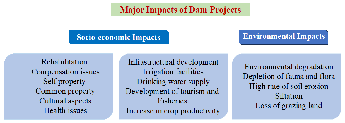
There are seven spatial dimensions of socio-economic impacts of dam projects, such as the upstream catchment and river, reservoir area, downstream river, irrigation areas, construction activities, settlement areas, and country, regional, and global impacts identified by Lerer & Scudder (1999) [
26]. WCD (2000) estimates that one-third of dams serve two or more primary purposes, among which hydropower projects play a significant role [
27]. Since dam projects are among the most long-lived infrastructure projects, their socio-economic impact is significant [
28]. They often take a longer time to commence, therefore, the rehabilitation of affected people remains an impediment [
29]. A Study estimates that more than 80 million people were displaced in the previous century. shows various socio-economic and environmental impacts of dam projects.
. Major impact of dam projects.
India has many multi-purpose river valley projects of different sizes and magnitudes. Some of the largest hydropower projects are the Bhakra-Nangal dam on the Sutlej River, the Hirakud dam on the Mahanadi River, and the Tehri high dam on the Bhagirathi and Bhilangana rivers. The Tehri high dam, Asia’s largest dam project, produces more than 5000 MW of electricity. It has remained controversial since its construction, with rehabilitation issues still being addressed by the project administration and affecting oustees. It took 40 years to complete, and 114 villages were affected by the dam project [
30]. The Kumaon Himalaya is an ecologically fragile and geologically sensitive region; therefore, the construction of big dams is not feasible [
31]. The Jamrani Irrigation Dam Project (JIDP) is a medium-scale irrigation project constructed on the Gaula River, on the foothills of the Nainital Hills, and adjacent to Bhabar region. It is expected to have a positive socio-economic impact and fewer adverse environmental effects.
Bhabar, a dry region of the Kumaon Himalaya, faces water scarcity, primarily during summer. Furthermore, the Gaula River is seasonal, becoming inundated during the monsoon season. Annual discharges of about 400 m3 may be expected in floods, while summer discharges may be reduced to only a few cubic meters of flow. The JIDP will play a key role in supplying ample drinking water, irrigating arable land, generating hydroelectricity, and controlling flash floods. The project will irrigate 57,065 ha of arable land, supply 42.7 million cubic meters (MCM) of water, and generate 14 MW of electricity annually. Additionally, intensity of irrigation will be expected to be increased from 158.85% to 196.88% [
32]. Many studies have been conducted on the socio-economic impacts, environmental aversion, political corruption, and governmental connections of large dams [
33,
34,
35,
36,
37,
38]. In addition, other studies were conducted on the importance of multi-purpose dam projects worldwide compared to other renewable energy projects and their relation to the impact of landscapes and public perception [
39]. Two additional important benefits of the dam projects are the sustainability related to water scarcity, which is mainly due to the intense climatic variability [
40,
41], and the protection from floods, which is directly linked to the change of human-flood distance on a global scale [
42]. However, no research has been carried out on the JIDP dam project. This study will bridge the gap and provide a way forward for suitably commencing the multi-purpose projects in the Himalayan region. It raises questions about dam projects socio-economic and environmental impacts and how they will sustain water supply for drinking and irrigation. Then, it studies the socio-economic and environmental impacts of JIDP. It investigates both the positive and adverse impacts of the dam project and suggests suitable rehabilitation packages for oustees. It was hypothesized that the JIDP has favourable impacts on both upstream and downstream areas.
2. Study Area
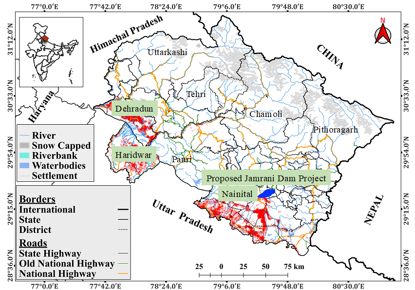
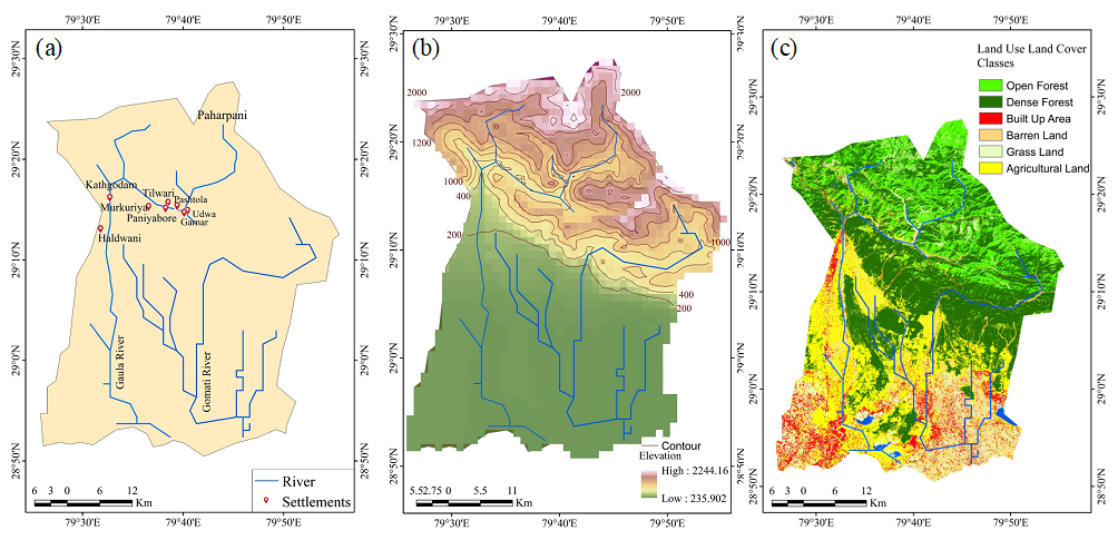
The Kumaon Himalaya is located in the eastern part of the Central Himalaya, bordered by Tibet in the north, Nepal in the east, Uttar Pradesh in the south, and the Garhwal Himalaya in the west. A large part of it is mountainous, with the northern part being snow-capped. A small portion of the land is plain, which includes USN and part of the Nainital district. These plain parts are known as the Tarai and Bhabar regions. Tarai is irrigated land, whereas Bhabar is dry and hot. The project is being constructed in the Bhabar region near Kathgodam on the Gaula River. The proposed dam axis stretches at 29°16′12.5″ N and 79°36′45.1″ E ( and ). The entire catchment of the dam project is facing water scarcity. The groundwater table has reached a low level, and many tube wells have dried up. 50–60 feet fall in groundwater levels has been noticed over the last 40 years (Irrigation Department, 2022). There are six villages located upstream of the dam project along the Gaula River. These villages are Tilwari, Murkuriya, Ganrar, Paniyabore, Udwa, and Pastola. A total population of 965 from 415 households in these six villages will be affected by the construction of the dam reservoir. Similarly, eight villages downstream and a vast arable land will benefit from the construction of the dam project.
. Location of Uttarakhand Himalaya, where JIDP is located.
. JIDP: (<b>a</b>) location map showing upstream villages, which will be submerged, (<b>b</b>) contour map of the study area, and (<b>c</b>) land use and land cover.
A 130.60 m high concrete gravity dam is proposed to be constructed over the Gaula River at Jamrani village, 10 km upstream of the Gaula Barrage in the Kumaon Himalaya. Additionally, a 4.52 km
2 water reservoir will be constructed. It is a multi-purpose project (MPP) funded by the Asian Development Bank (ADB). The main objective of this dam is to provide irrigation for approximately 57,065 ha in the Uttarakhand and Uttar Pradesh states. The Jamrani Dam reservoir has a capacity of 208 MCM with live storage of 142.70 MCM, of which 42.7 MCM will be utilized for drinking and irrigation. It will also recharge groundwater by about 100 MCM throughout the year.
The population of the twin cities of Haldwani and Kathgodam is expected to increase to two million by 2051 due to urbanization and natural population growth. The mounting population of these two cities is facing water scarcity. Furthermore, the high exploitation of groundwater has already led to significant depletion. This dam project will supply ample drinking water to these cities. In addition, it will generate 14 MW of hydroelectricity and enhance the development of tourism and pisciculture.
Overall, the project envisages benefits such as drinking water, irrigation, power generation, fisheries, flood control, tourism, reduced dependency on groundwater, groundwater recharge, employment, and better road connectivity. The cost of the project will be 25.84 billion at the 2018 price level, of which the cost of the drinking water component will be approximately 3.55 billion.
3. History of JIDP and Its Economic Significance
It is proposed that the JIDP be constructed on the Gaula River, a tributary of the Ramganga River. It is a flashy seasonal river, originating from Paharpani village in the Kumaon Hills, and flows through the southern parts of Kathgodam, Haldwani, Kichha, and Shahi before joining the Ramganga River. Prior to the construction of the Gaula Barrage and canal, the Gaula River was devastating downstream areas due to huge flash floods occurring during the monsoon season every year. Furthermore, this region remains dry during the summer season and is therefore, called the Bhabar region. Vast arable land remains infertile due to a lack of irrigation facilities. Additionally, there is a huge scarcity of drinking water in the upstream and downstream areas. Considering this situation, the Uttar Pradesh Government decided to construct a dam project on the Gaula River in its upstream area. In 1975, the government approved the first phase, which cost INR 0.61 billion. This led to the construction of the Gaula Barrage, a 40.5 km long canal system, and the renovation of approximately 244 km of canal systems, which was completed in 1981. The Gaula River has a runoff of 470.21 Mm3, and the Gaula Canal has a runoff of 208 Mm3. The Gaula barrage irrigates additional areas of Nainital and USN districts in Uttarakhand and Rampur and Bareilly districts in Uttar Pradesh. The JIDP is an ambitious second phase project that has yet to be initiated. GIS mapping of canals, reservoirs, and the command area, along with remote sensing mapping of current cropping patterns for all seasons, is pending. The rest of the water from the Gaula River (after the Gaula canal) flows downstream and is mainly unused. Thus, the proposed dam project will utilize it by creating an additional irrigation potential of approximately 57,065 ha and will increase irrigation intensity from 158.85% to 196.88%. It will also lead to an increase in socio-economic development in the upstream and downstream river basins and control flash floods.
4. Methodology
A combined approach of qualitative and quantitative methods was employed in this study. Data were collected from two sources: primary and secondary. For the collection of primary data, a case study of six villages was conducted. Out of a total of 415 households, being affected by the construction of the proposed dam project, 122 families living in households were interviewed for their perception of the construction of the dam project. A structured questionnaire was constructed and based on it, the interview was conducted to understand the willingness of the affected people to rehabilitate and their opinions on the economic and environmental impacts of JIDP, as well as on rehabilitation, resettlement, and compensation packages. The interview was conducted in January 2023, when the author visited the proposed dam side and its affected areas. The interviewees were selected using purposive sampling method and the availability of interviewees in the villages. Furthermore, an observational study was conducted on the dam reservoir area and its catchment regarding biodiversity loss and environmental degradation.
Secondary data were obtained from the Irrigation Department, Government of Uttarakhand’s report 2020, Dehradun, focusing on land use patterns, forest types, and agriculture in both upstream and downstream villages. A detailed data of 415 affected households were obtained from secondary sources. These villages have a combined population of 965. A total of 47.39 ha of land was acquired from six villages for the dam construction (). The collected data include various aspects such as population structure, socio-economic status, community land, temples, schools, hospitals, land use patterns, cropping patterns, benefits of the dam project, including ample water supply for drinking and irrigation, and hydropower generation. A location map and three other maps—drainage, contours, and land use—were constructed using Geographical Information System (GIS) technology from satellite data. Both primary and secondary data were analyzed using statistical methods, graphs, and maps.
.
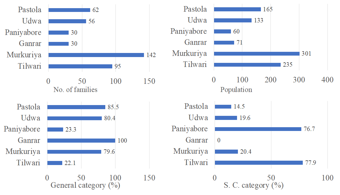
Villages, affected households, total population, and agricultural land acquired due to JIDP.
| S. No. |
Villages |
Total Affected Households |
Total Population |
Agricultural Land Acquired (ha) |
| 1. |
Tilwari |
95 |
235 |
3.89 |
| 2. |
Murkuriya |
142 |
301 |
20.8 |
| 3. |
Udwa |
56 |
133 |
2.8 |
| 4. |
Pastola |
62 |
165 |
6.8 |
| 5. |
Ganrar |
30 |
71 |
9.1 |
| 6. |
Paniyabore |
30 |
60 |
4 |
| 7. |
Total |
415 |
965 |
47.39 |
5. Results
5.1. Land Use Pattern in the Proposed Dam Reservoir and Its Catchment
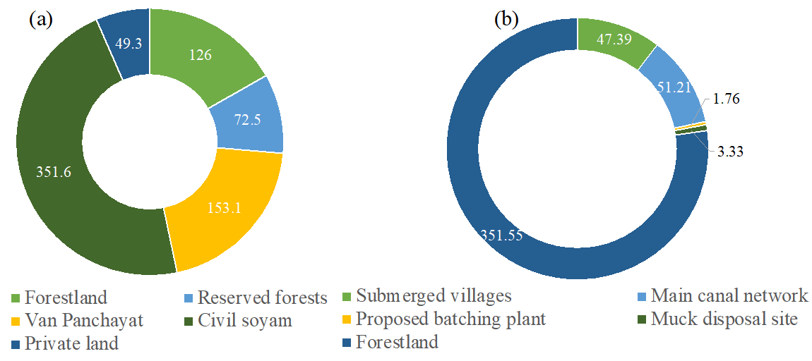
The land use pattern of the proposed dam reservoir mainly comprises five categories—forestland, reserve forests, Van Panchayat, civil soyam, and private land. Private land includes 821 landholders from six villages. The highest area is under civil soyam (351.6 ha), followed by Van Panchayat (153.1 ha) and forestland (126 ha). Private land has the lowest proportion, and about 72.5 ha of land is under reserve forests (a). The dam reservoir requires a total of 457.19 ha of land, which includes 47.39 ha of land (10.4%) from the largely affected six villages. Approximately 51.21 ha of land (11.6%) is required for the main and feeder canal networks. About 351.55 ha of forestland will be submerged. Other land uses have less than 5 ha of area to be submerged (b).
The land use of the catchment area of the dam project is presented in . Out of the total 55,053 ha catchment area, dense forests cover 46.54% of the area, followed by medium dense forests, which account for 25.73%. The area under low, dense forests is 10.35%. Agricultural land comprises only 9.30% of the area, while the area under scrubs/bushes is 4.06%. River bed/barren land accounts for 1.48%, water bodies for 0.05%, and settlement/built-up areas for 2.49%.
. (<b>a</b>) Land use (ha) in the dam catchment (<b>b</b>) Land (ha) required for dam construction.
.
Land use of catchment area of dam project.
| S. No. |
Land Use Category |
Area (ha) |
Area (%) |
| 1. |
Dense forests |
25,622.41 |
46.54 |
| 2. |
Medium dense forests |
14,167.68 |
25.73 |
| 3. |
Low dense forests |
5696.93 |
10.35 |
| 4. |
Agricultural land |
5120.04 |
9.30 |
| 5. |
Scrubs/bushes |
2234.24 |
4.06 |
| 6. |
River bed/barren land |
815.86 |
1.48 |
| 7. |
Water bodies |
24.93 |
0.05 |
| 8. |
Settlement/built-up area |
1370.90 |
2.49 |
| 9. |
Total |
55,053 |
100 |
The proposed JIDP will irrigate about 57,065 ha of arable land in the Bhabar, Tarai, and Gangetic sub-regions. Out of this, a total of 4966 ha of land in the Bhabar sub-region will be irrigated. Similarly, the dam project will irrigate 4492 ha of land in the Tarai sub-region and 47,607 ha of land in the Gangetic sub-region (
).
.
Proposed area for irrigation under dam project.
| Sub-Regions |
Area (ha) |
% of Total Area |
| Bhabar sub-region |
4966 |
8.7 |
| Tarai sub-region |
4492 |
7.9 |
| Gangetic sub-region |
47,607 |
83.4 |
| Total |
57,065 |
100 |
We analyzed various land uses of households, which are likely to be of equal size. Agricultural land of eight households, residential houses of 72 households, commercial areas of one household, and agricultural and residential areas of 334 households were surveyed for acquisition (
).
.
Various land uses and directly affected families of JIDP.
| Land under Acquisition |
No. of Affected Families |
% of Total Affected Families |
| Agricultural land |
8 |
1.9 |
| Residential land |
72 |
17.3 |
| Commercial land |
1 |
0.3 |
| Agricultural and residential land |
334 |
80.5 |
| Total |
415 |
100 |
5.2. Population Structure of Affected Villages
A total of 965 people from 415 households will be affected by the proposed construction of the JIDP. The highest number of people and households is from Murkuriya village, representing approximately one-third of the total population and households. This is followed by Tilwari village, with 95 families and 235 people. Pastola and Udwa villages also have a substantial number of households and population. Thirty households from Ganrar and Paniyabore villages are directly affected by the dam project. Additionally, seven temples, three schools, one hospital, one fair price shop, one village connected by road (others have to walk 2–3 km), one forest guest house, one community center, fishing activities, and a few hotels will be affected due to the JIDP, most of which are located in Murkuriya village. In the downstream area, there are eight villages that will benefit from the dam project. These villages are Pania Mehta, Gumalaon, Rausil, Pasauli, Bhorsa, Anna, Kula, Dehra, and Amritpur. About 79 households in these villages will be affected by the dam project.
Both general category and Scheduled Castes people inhabit all the affected villages. General caste people dominate in number, constituting about 65% of the total population, while Scheduled Castes account for one-third of the population. However, the proportion of the population from both castes varies from village to village. In Ganrar village, only general caste people inhabit. Similarly, Pastola, Udwa, and Murkuriya villages have over 75% of the general caste population. In contrast, Tilwari and Paniyabore villages have over 75% Scheduled Castes population ().
. No. of families, population, general category, and Scheduled Castes category.
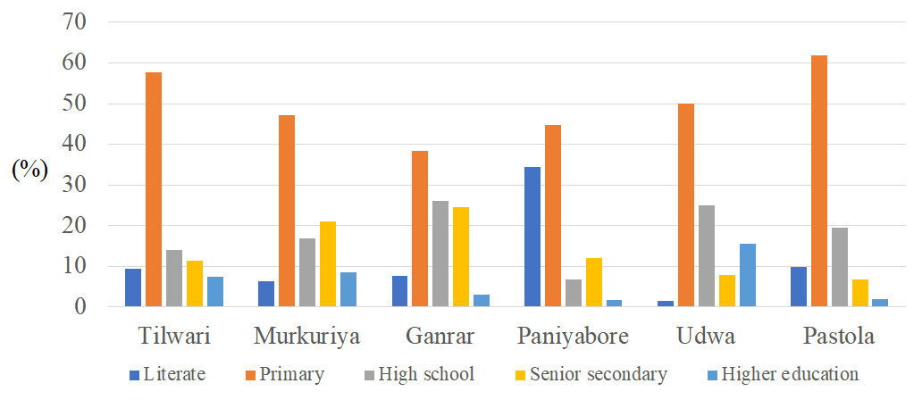
Village-wise levels of education were analyzed, revealing that the highest proportion of the population has completed primary education (61.8%), followed by high school (19.6%). Approximately 9.8% of the population is literate, 6.8% have completed senior secondary education, and only 2% have higher education qualifications (). The level of education varies from village to village, although the variation is nominal.
. Level of education in the affected villages.
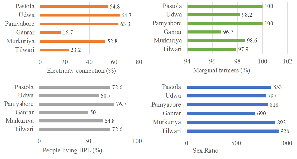
In this section, four variables—electricity connection in households, number of small farmers, people living below the poverty line, and sex ratio—were examined. Although the Kumaon Himalaya is on its way to achieving 100% electrification in rural areas, about 46 families in the fully affected villages have no electricity. The highest percentage of households with electricity connections is in Udwa village (64.3%), followed by Paniyabore village (64.3%). The lowest number of families with electricity are from Ganrar village (16.7%), followed by Tilwari village (23.2%). Out of the total 415 families, 409 are small farmers. In Paniyabore village, all farmers are small farmers, and similarly, in all villages, more than 95% of the families are small farmers. A large number of families (278) are living below the poverty line (BPL) in all villages, which is 67% of the total population. The number of BPL families varies from village to village, depending on the total number of households. The highest percentage of people living below the poverty line was observed in Paniyabore village (76.7%), followed by both Tilwari and Pastola villages (72.6% each). The lowest number of BPL families was recorded in Ganrar (15 families). The sex ratio among the affected villages is very low, with 859 women for every thousand men. The highest sex ratio was noticed in Tilwari village, with more than 900, followed by Murkuriya, Pastola, and Paniyabore villages (each having more than 800). Udwa had a sex ratio of less than 800, and Ganrar had less than 700 ().
. Socio-economic status of the affected villages.
The socio-economic status—including affected families, total population, agricultural land acquired, general population, Scheduled Caste population, people living below the poverty line, and the number of Marginal farmers—in the affected villages was analyzed (). These numbers vary from village to village depending on the number of affected families. This means that all variables are dependent on the number of families in each village.
.
Statistic of socio-economic status of the affected villages and people (n = 415).
| Statistic |
Total Affected Families |
Total Population |
Agricultural Land Acquired (ha) |
GC |
SC |
BPL |
MF |
| Maximum |
142 |
301 |
20.8 |
113 |
74 |
92 |
140 |
| Minimum |
30 |
60 |
2.8 |
7 |
0 |
15 |
29 |
| Mean |
69.2 |
160.8 |
7.9 |
44.8 |
24.3 |
46.3 |
68.2 |
| Standard Deviation |
43.05 |
94 |
6.7 |
37.2 |
26.4 |
29.3 |
42.4 |
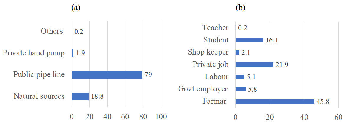
5.4. Major Water Sources and Occupational Structure
Water scarcity mainly prevails during the summer season. Most of the water supply in all six affected villages is provided by public pipelines (79%), followed by natural sources (18.8%). Private hand pumps are also used (1.9%). The occupational structure depicts that out of the total population of the affected villages, 45.8% are engaged in agriculture, followed by 21.9% working in private jobs, and students represent 16.1% of the total population. About 4.1% of people are government employees, and 5.1% are laborers. Very few people are engaged in business and other occupations (
).
. (<b>a</b>) Major water sources existed in the affected villages and (<b>b</b>) occupational structure of the affected people.
The economic impact of the JIDP will be significant. There are several reasons for its economic benefits. The catchment of the proposed area of the dam project is 55,053 ha, of which 5120.04 ha is arable land. This dam project will irrigate 5120.04 ha of arable land after its completion. Furthermore, a total of 57,065 ha of arable land in the Bhabar sub-region, Tarai sub-region, and Gangetic sub-region will be irrigated. The entire region is fertile and needs ample water for irrigation to increase the production and productivity of different crops. The proposed dam project will meet the water demand and generate 14 MW of electricity annually. The dam project will supply ample drinking water to the twin cities of Haldwani-Kathgodam, which are increasing in population. These twin cities are located in the foothill plains of the Kumaon hills, which have suitable landscapes. People from rural areas largely out-migrate to these cities. In addition, natural growth in population is also high. Therefore, these cities are spanning towards its periphery with declining carrying capacity. The proposed dam aims to supply drinking water to these twin cities till 2051 and further. The entire area is the perfect tourist destination as Nainital hill town is located about 20 km from the proposed dam project. Hundreds of thousands of tourists from the Indian sub-continent and abroad visit Nainital in both seasons. During the summer, when heat strokes hit the Ganges valley and South India, tourists visit Nainital for leisure and during winter, they enjoy snowfall. Further, Bhawali town and its surrounding areas have a pleasant climate where tourists visit for health tourism and to perform meditation. These activities lead to generating high income and augmenting employment. The dam project will further help in increasing the number of tourists in this region after the development of water sports and will boost the economy of rural people through employment.
5.6. Environmental Impact of the Dam Project
The primary environmental impact of the dam project is the submergence of approximately 703.2 ha, encompassing various land uses, including civil soyam land, Van Panchayat land, forest land, private land, and reserve forests. A total of 415 (households) landholders across six villages will have their land submerged. This will further contribute to soil erosion and extensive land degradation. The forestland mainly consists of dense pine trees and shrubs in the lower altitudes and mixed-oak forests in the higher altitudes of the dam project. Both forests are economically viable, environmentally sound, and highly suitable for carbon sequestration. Pine forests provide firewood and wood for making furniture and buildings. Mixed-oak forests have rich biodiversity, comprising oak, Tilonj, Kafal, and Tejpatta, very valuable trees. Further, these forests provide wild fruits, which have high nutritional value. These forests control soil erosion of fragile landscapes. Due to the construction of the Jamrani dam project, these forests will be degraded, which will lead to environmental degradation. This part of the Kumaon Himalaya, known as the Shivalik Hills, is ecologically fragile and highly vulnerable to severe landslides. Consequently, soil erosion and land degradation following the construction of the dam reservoir will pose a future problem. Furthermore, due to degraded land in its surrounding areas, high siltation in dam reservoirs will further lead to future catastrophes, including low water quality. Suitable planning, including technology intervention, is required to conserve the degraded land before and after the commencement of the project.
5.7. Rehabilitation and Compensation Issues
Proper rehabilitation of oustees and suitable compensation—land and property for those affected—are the two paramount issues facing the people displaced by the dam project. These problems are particularly prominent in developing and underdeveloped countries with scarce financial resources. In the proposed JIDP, 821 households from six villages will be significantly affected, and their rehabilitation and compensation will pose a major challenge. Apart from land-for-land compensation and cash for building construction, many other issues are associated with rehabilitation and compensation. The location where dam oustees will be rehabilitated and the rehabilitation of common property resources are two significant problems the oustees face. In the present study area, the affected people have expressed a demand to be relocated to the Bhabar region, particularly around Haldwani city. Their current habitats are mainly in the foothills of the Himalayas, which are not very productive, and relocating them to the fertile Bhabar region would be beneficial. However, in the meantime, compensation for property and common resources, including common grasslands, cremation space, playgrounds, educational and other governmental institutions, and cultural belongingness, may lead to several disputes if not properly handled.
5.8. People’s Perception of Dam Project and Rehabilitation (n = 122)
Out of the total 415 households in the affected area, a total of 122 heads of households from all six villages were interviewed () regarding their perception of the proposed dam construction project. The respondents were asked six questions in total. Since the project has yet to be constructed, 8.2% of the heads of households were unaware of the dam project, and 11.5% did not respond to the question. Of the households interviewed, 57.4% believed they would be fully affected by the dam’s construction, 24.6% responded that they would not be affected, and 18% did not answer. Regarding the potential benefits of the dam project to the region, 55.7% believed it would be highly beneficial. Others either responded negatively or did not answer. More than 50% of respondents indicated that the dam project is not environmentally sound, citing concerns that it would lead to significant land degradation. When asked about their willingness to relocate, 63.9% of the heads of households indicated they were willing to do so, provided they were given land in the Bhabar area surrounding Haldwani city. About 36 families expressed unwillingness to relocate, and eight respondents did not answer. The final question was about compensation. Approximately 27.9% of respondents wanted full cash compensation for all their properties and preferred to handle their own relocation. For land and house compensation, 37.7% of respondents favoured this option, while 24.4% preferred a combination of cash, land, and house compensation. Additionally, 9.8% did not answer. The data shows that a significant number of people are open to relocation, provided they receive essential facilities such as schools, hospitals, banks, post offices, suitable connectivity, playgrounds, cremation areas, and cultural amenities.
.
People’s perception of dam project and rehabilitation (n = 122).
| Questions |
Response |
Number |
% |
| 1. |
Do you aware about the JIDP? |
Yes |
98 |
80.3 |
| No |
10 |
8.2 |
| No answer |
14 |
11.5 |
| 2. |
Will you be fully affected by the dam project? |
Yes |
70 |
57.4 |
| No |
30 |
24.6 |
| No answer |
22 |
18 |
| 3. |
Do you think that this project will be beneficial to the region? |
Yes |
68 |
55.7 |
| No |
34 |
27.9 |
| No answer |
20 |
16.4 |
| 4. |
Is this project environmentally sound? |
Yes |
48 |
39.3 |
| No |
62 |
50.8 |
| No answer |
12 |
9.8 |
| 5. |
Will you be willing to rehabilitate to other areas? |
Yes |
78 |
63.9 |
| No |
36 |
29.5 |
| No answer |
8 |
6.6 |
| 6. |
What type of compensation do you need? |
Cash compensation |
22 |
28.2 |
| Land and house compensation |
32 |
41 |
| Both |
18 |
23.1 |
| No answer |
6 |
7.7 |
6. Discussion
The socio-economic and environmental impacts of JIDP were assessed using both qualitative and quantitative approaches. The study revealed that JIDP has an immense impact on the socio-economy and environment of the affected areas. Furthermore, the rehabilitation of oustees will be a substantial impediment after the commencement of the project. The socio-economic status of the affected villages of the dam project depicted that there are 965 persons of 415 households, which will be affected by the construction of the dam project. These households are mainly involved in practicing agriculture and private jobs. Since agriculture is rainfed and practiced using traditional methods, its output is insufficient. The arable land in the affected villages is quite less. The landscape is rugged, and the land is unfertile. These villages are not fully electrified. Furthermore, water scarcity prevails during the dry season, and even people have to travel miles to fetch water. A large number of people are living under the poverty line and the farmers are mainly marginal. All these factors support the construction of JIDP. This study further reveals that only a small proportion of the population, 965 persons, are affected by the dam projects. The construction of the dam project will not affect much agricultural land, crops, and community land because their proportion is significantly less. In the six affected villages, only 7 temples, three schools, and one hospital are located, which can easily be resettled in rehabilitation areas,
i.e., the Bhabar region. Most of the area is covered by pine forests, which will not be a problem for rehabilitation.
In terms of the economic impact of the dam project, the downstream catchment area—Tarai, Bhabar, and the sub-Gangetic basin of Uttarakhand and Uttar Pradesh states has a vast arable land, which is very fertile, however, it faces severe water shortage. This dam project will irrigate the vast arable land, leading to high crop production and productivity. This project will feed a vast and increasing population of Haldwani and Kathgodam twin cities. It is estimated that the population of these twin cities will be more than two million by 2051 due to high in-migration and natural population growth. In addition, the Gaula River is seasonal; however, during the monsoon season, flash floods occur in this river and often inundate the downstream area, leading to a huge loss of life and property. In the winter season, the remains dry, and water scarcity prevails. The proposed dam construction will control the flash floods of the Gaula River and supply ample water throughout the year. Moreover, the entire region is a well-known tourist destination, and the huge dam reservoir will further enhance tourism activities, fisheries, and employment opportunities. The Kumaon Himalaya has a number of hill stations, such as Nainital, Almora, Ranikhet, and Kosi. Hundreds of thousands of tourists visit these hill stations yearly, generating income and augmenting employment. As a result, tourism shares about 52% of GDP (UTDB) [
43,
44].
In the meantime, the JIDP will have an adverse environmental impact (). The construction of dam reservoir will lead to the submergence of a total of 703.2 ha of land, including forestland and arable land. Environmental degradation, forest depletion, soil erosion, and siltation will be the major environmental problems. It will also impact the faunal species.
.
Impact of JIDP on various components.
| Components |
Sub-Components |
Impacts |
| Socio-economic |
Population |
People are involved in practicing agriculture and private jobs. They will be rehabilitated. |
| Irrigation |
A vast land in downstream areas will be irrigated, which will lead to an increase in the production and productivity of crops. |
| Drinking |
This region faces drinking water scarcity. The construction of dam project will supply ample water throughout the year. |
| Infrastructural development |
This dam project will lead to development of infrastructural facilities. |
| Environmental |
Land degradation |
Land degradation will have a negative impact on the region. |
| Forest depletion |
Forests, mainly pine forests, will be depleted. |
| Soil erosion |
The rate of soil erosion will increase. |
| Siltation |
The dam project will lead to siltation in the reservoir. |
| Rehabilitation issues |
Land compensation |
To acquire a vast arable land for oustees may be a problem to the dam authority. |
| Cash compensation |
Case compensation will not be a problem if it is distributed honestly. |
| Compensation for community properties |
Acquiring land for community properties and distributing cash compensation for the same remained a problem related to dam construction in the past. I panic if compensation is not given for community properties. |
One of the significant aspects of this project is planning for compensation packages and the rehabilitation of oustees. The data on occupational structure show that approximately half of the population in the affected area of the dam project is involved in practicing agriculture, which is their main occupation and the major means of livelihood. For the smooth commencement of the dam project, the rehabilitation of marginal farmers to other safe sites will be an important task. Many of the marginal farmers are willing to be rehabilitated to the Bhabar region, which is located in the dam catchment area. There should be provisions for appropriate compensation packages for the oustees regarding agricultural land, houses, cowsheds, and common properties such as grasslands, temples, schools, hospitals, post offices, banks, etc. The dam authority has to note the oustees’ belongingness, culture, and beliefs and accordingly fix compensation. Generally, it is always difficult for oustees to adapt to different geographical and cultural locations as it takes a long time; therefore, a sufficient amount of compensation should be allotted to every oustees. Better education, institutional facilities, and access to markets should be provided to the oustees before or immediately after they are rehabilitated.
Mega-hydropower projects in the Himalayan ecosystems are not suitable due to their high fragility, sensitivity, and activeness. Furthermore, the rehabilitation of a large affected population remains an issue, particularly in the Himalayan region, where livelihoods are very tough due to the rough and rugged terrain and limited livelihood options. However, micro-level dam projects may have highly favourable economic and social impacts. Under this scheme, a micro-hydropower project will generate 14 MW of electricity annually, which will supply it to the surrounding areas. The Kumaon Himalaya hosts many glacier-fed perennial rivers, such as the Saryu-Kali system and its numerous tributaries, which have high potential to provide ample water for drinking and irrigation. Meanwhile, the entire region is suffering from water scarcity, and this region is known as Bhabar, which literally means dry region. Many crop cultivars/races are rainfed due to a lack of ample water supply. Unlike the other dam projects in the Himalayan region, which are Megha projects constructed in the highly vulnerable areas and where rehabilitation issues are prominent, this dam project is located in a relatively less vulnerable area. Affected population size is less; therefore, the JIDP construction will be a milestone for water resource management.
7. Conclusions
This study examined the socio-economic and environmental impacts of the JIDP in the Kumaon Himalaya. It noticed that the project will have high socio-economic benefits as it irrigates a vast arable land of its downstream catchment and will provide ample water to the twin cities of Haldwani and Kathgodam. In the meantime, it will not have much adverse impact on the rehabilitation of oustees and on the environment. The findings of the study depict that only six villages upstream of the river are directly affected by the irrigation project, with a total population of 965 individuals in 415 households. Additionally, a total of 457.19 ha of land will be submerged under the dam reservoir, of which over 70% is forested area. Meanwhile, the project will irrigate approximately 57,065 ha of arable land in the Tarai, Bhabar, and Gangetic valleys of both Uttarakhand and Uttar Pradesh. A water reservoir with a height of 130.60 m and covering an area of 4.52 square kilometers will provide drinking water to the twin cities of Haldwani and Kathgodam until 2051 and will generate 14 MW of electricity annually. The downstream villages will also benefit from this project as they will receive ample water. Additionally, this irrigation project will have several other favourable impacts, such as fisheries and tourism development. It will also control the inundation of the Gaula River, which will occur mainly during the monsoon season.
The catchment area of the JIDP is known as the Tarai and Bhabar region, comprising fertile land. The construction of the dam will enhance the production and productivity of various crops, including food grains, fruits, and vegetables, after supplying ample water. It will also convert barren land into agricultural land. There will be a proportional increase in electricity supply, which will further help establish small-scale industries. Ample water supply, flood control during the monsoon season, fisheries, and tourism development will be the prominent benefits of the project. This dam reservoir will be constructed close to Bhimtal, Bhawali, Nainital, and Corbett National Park, popular tourist destinations that will attract more tourists. An increase in the groundwater table will be another benefit of the project.
For the smooth functioning of the irrigation project, some appropriate suggestions are given. The most important one is the resettlement and rehabilitation of oustees, under which compensation for houses, cowsheds, agricultural land, and other infrastructural facilities—both individual and community—can be provided at the household level. In the rehabilitated areas, proper infrastructural facilities such as schools, colleges, hospitals, post offices, banks, and transportation can be provided before the commencement of the project. Extra financial compensation for oustees’ belongings and cultural affinities can be given in time. The forestland that will be submerged into the dam reservoir can be compensated through plantation in the downstream area. This will lead to the prosperity of the people and the region. The important part of the dam project is the use of robust technological tools for the sustainable construction of the dam. Many dam projects in the Himalaya region could not succeed due to a lack of proper technology and corruption.
Acknowledgments
The author wishes to thank all who assisted in conducting this work.
Author Contributions
This is a sole author paper. The author contributed to the study conception, design, material preparation, data collection, analysis, writing paper, and solely submitted it.
Ethics Statement
Not applicable. The author confirms that this research does not involve in humans and animals.
Informed Consent Statement
Not applicable. The author declares that this work does not contain any material from any individual.
Data Availability Statement
The datasets are not available.
Funding
The authors declare that no funds are received during this work.
Declaration of Competing Interest
The author declares no financial or non-financial interests exist that are directly or indirectly related to this work.
References
1.
World Commission on Dams. Dams and Development: A New Framework for Decision-Making: The Report of the World Commission on Dams; Earthscan: London, UK, 2000.
2.
Zarfl C, Lumsdon AE, Berlekamp J, Tydecks L, Tockner K. A global boom in hydropower dam construction.
Aquat. Sci. 2015,
77, 161–170. doi:10.1007/s00027-014-0377-0.
[Google Scholar]
3.
International Hydropower Association. Hydropower Sustainability Assessment Protocol. 2010. Available online: http://www.hydrosustainability.org/IHAHydro4Life/media/PDFs/Protocol/hy dropower-sustainability-assessment-protocol_web.pdf (accessed on 26 January 2025).
4.
World Energy Council. Energy Resources/Hydropower.
Eng. Geol. 2015,
51, 183–193.
[Google Scholar]
5.
ICOLD. Definition of a Large Dam. International Commission on Large Dams. 2022.Available online: https://www .icold-cigb.org/GB/dams/definition_of_a_large_dam.asp (accessed on 28 January 2025).
6.
Agrawala S, Raksakulthai V, van Aalst M, Larsen P, Smith J, Reynolds J. Development and Climate Change in Nepal: Focus on Water Resources and Hydropower; Organization for Economic Cooperation and Development: Paris, France, 2003; p. 64.
7.
Kim B. Infrastructure Development for the Economic Development in Developing Countries: Lessons from Korea and Japan; GSICS Working Paper Series; Kobe University: Kobe, Japan, 2006.
8.
Ansar A, Flyvbjerg B, Budzier A, Lunn D. Should we build more large dams? The actual costs of hydropower megaproject development.
Energ. Pol. 2014,
69, 43–56.
[Google Scholar]
9.
Flyvbjerg B, Nils B, Werner R. Megaprojects and Risk: An Anatomy of Ambition; Cambridge University Press: Cambridge, UK, 2003.
10.
Shah Z, Kumar MD. In the midst of the large dam controversy: Objectives, criteria for assessing large water storages in the developing world.
Water Resour. Manag. 2008,
22, 824–1799.
[Google Scholar]
11.
McCartney MP. Decision Support Systems for Large Dam Planning and Operation in Africa; IWMI: Colombo, Sri Lanka, 2007.
12.
Sati VP. Environmental and economic implications of multipurpose river valley projects: A case for the madikheda dam (india).
J. Environ. Res. Develop. 2008,
2, 885–895.
[Google Scholar]
13.
McCully P. Silenced Rivers: The Ecology and Politics of Large Dams Development, 2nd ed.; Zed Books: London, UK, 2001.
14.
Smith SR. Outline Programme for Hydro-Electric Development in West Africa to 1980. In Dams in Africa: An Inter- Disciplinary Study of Man-Made Lakes in Africa; Rubin N, Werren WM, Eds.; Frank Case and Co., Ltd.: London, UK, 1968.
15.
Deji C. Engineering Geological Problems in the Three Gorges Project on the Dams. An Overview; WCD: New Delhi, India, 1999.
16.
Pandey AP, Chadha RK. Surface loading and triggered earthquakes in the Koyna–Warna region, western India.
Phys. Earth Planet. Inter. 2003,
139, 207–223.
[Google Scholar]
17.
Kerr RA, Stone R. A human trigger for the great quake of Sichuan?
Science 2009,
323, 322.
[Google Scholar]
18.
Duflo E, Pande R. Dams.
Q. J. Econ. 2007,
122, 601–646. doi:10.1162/qjec.122.2.601.
[Google Scholar]
19.
Richter BD, Postel S, Revenga C, Scudder T, Lehner B, Churchill A, et al. Lost in development’s shadow: The downstream human consequences of dams.
Water Alter. 2010,
3, 14–42.
[Google Scholar]
20.
Égré D, Senécal P. Social impact assessments of large dams throughout the world: lessons learned over two decades.
Impact Assess. Proj. Apprais. 2003,
21, 215–224.
[Google Scholar]
21.
Brown PH, Tullos D, Tilt B, Magee D, Wolf AT. Modeling the costs and benefits of dam construction from a multidisciplinary perspective.
J. Environ. Manag. 2009,
90, 303–311.
[Google Scholar]
22.
Shields MA. Social Impact Studies: An Expository Analysis.
Environ. Behav. 1974,
7, 265–284.
[Google Scholar]
23.
Vanclay F. Conceptualising social impacts.
Environ. Impact Assess. Rev. 2002,
22, 183–211. doi:10.1016/S0195- 9255(01)00105-6.
[Google Scholar]
24.
Greathouse EA, Pringle CM, McDowell WH, Holmquist JG. Indirect upstream effects of dams: consequences of migratory consumer extirpation in Puerto Rico.
Ecol. Appl. 2006,
16, 339–352.
[Google Scholar]
25.
Strobl E, Strobl RO. The distributional impact of large dams: Evidence from cropland productivity in Africa.
J. Dev. Exon. 2011,
96, 432–450. doi:10.1016/j.jdeveco.2010.08.005.
[Google Scholar]
26.
Lerer LB, Scudder T. Health impacts of large dams.
Environ. Impact Assess. Rev. 1999,
19, 113–123. doi:10.1016/S0195-9255(98)00041-9.
[Google Scholar]
27.
Platts. The Top 100—Part I: The World’s Largest Power Plants [Internet]. 2015. Available online: http://www.industcards.com/top-100-pt-1.htm (accessed on 21 February 2025).
28.
Takesada N. Japanese experience of involuntary resettlement: Long-term consequences of resettlement for the construction of the Ikawa Dam.
Int. J. Water Resour. Dev. 2009,
25, 419–430. doi:10.1080/07900620902965459.
[Google Scholar]
29.
SRP. Theodore Roosevelt Dam [Internet]. 2015. Available online: http://www.srpnet.com/water/dams/roosevelt.aspx (accessed on 21 February 2025).
30.
Sati VP. Landscape vulnerability and rehabilitation issues: A study of hydropower projects in the Garhwal region, Himalaya.
Nat. Hazards 2014,
75, 2265–2278. doi:10.1007/s11069-014-1430-y.
[Google Scholar]
31.
Sati VP. Himalaya on the Threshold of Change; Springer International Publishers: Cham, Switzerland, 2019; 250p. ISBN: 978-3-030-14179-0.
32.
JDMP. Social Impact Assessment Project, Jamrani Dam Multipurpose Project; Government of Uttarakhand’s Report: Nainital, India, 2020.
33.
Everard M. The Hydropolitics of Dams: Engineering or Ecosystems?; Zed Books Ltd.: London, UK, 2013.
34.
Tischler J. Light and Power for a Multiracial Nation: The Kariba Dam Scheme in the Central African Federation; Springer: Berlin/Heidelberg, Germany, 2013.
35.
Isaacman AF, Isaacman BS. Dams, Displacement, and the Delusion of Development: Cahora Bassa and Its Legacies in Mozambique, 1965–2007; Ohio University Press: Athens, OH, USA, 2013.
36.
Biswas AK, Tortajada C. Impacts of the High Aswan Dam. In Impacts of large Dams: A Global Assessment; Springer: Berlin/Heidelberg, Germany, 2012; pp. 379–395.
37.
McDonald K, Bosshard P, Brewer N. Exporting dams: China’s hydropower industry goes global.
J. Environ. Manag. 2009,
90 (Suppl 3), S294–S302.
[Google Scholar]
38.
Marsh RM.
Getting ahead and falling behind: a sociological elaboration of Sen’s theory of human development. Soc. Sci. Q. 2014,
95, 1001–1021.
[Google Scholar]
39.
Ioannidis R, Koutsoyiannis D. A review of land use, visibility and public perception of renewable energy in the context of landscape impact.
Appl. Energy 2020,
276, 115367. doi:10.1016/j.apenergy.2020.115367.
[Google Scholar]
40.
Hurst HE. Long-term storage capacity of reservoirs.
Trans. Am. Soc. Civ. Eng. 2021,
116, 770–799. doi:10.1061/TACEAT.0006518.
[Google Scholar]
41.
Dimitriadis PD, Koutsoyiannis T, Iliopoulou, Papanicolaou P. A global-scale investigation of stochastic similarities in marginal distribution and dependence structure of key hydrological-cycle processes.
Hydrology 2021,
8, 59, doi:10.3390/hydrology8020059.
[Google Scholar]
42.
Wang N, Sun F, Koutsoyiannis D, Iliopoulou T, Wang T, Wang H, et al. How can Changes in the Human-Flood Distance Mitigate Flood Fatalities and Displacement?
Geophys. Res. Lett. 2023,
50, e2023GL105064. doi:10.1029/2023GL105064.
[Google Scholar]
43.
UTDB. Uttarakhand Tourism Development Board Report; Government of Uttarakhand: Dehradun, India, 2021.
44.
Sati VP, Banergee S. Sustainable Homestay Tourism for Enhancing Rural Livelihood in the Uttarakhand Himalaya: A Study of the Tons River Basin.
BIO Web Conf. 2025,
151, 03001. doi:10.1051/bioconf/202515103001.
[Google Scholar]