Article Open Access
Received: 25 April 2024 Accepted: 09 July 2024 Published: 10 July 2024

© 2024 The authors. This is an open access article under the Creative Commons Attribution 4.0 International License (https://creativecommons.org/licenses/by/4.0/).
Due to their expertise, engineers can identify potential risks that are not easily analyzed. In this paper, we present a rural area that we highlighted as an area with high flood risk, and therefore we conducted a systematic on-site inspection along the river at its initial condition. In the inspections, various points of the riverbed were documented, while, when a severe storm event hit the area (after few months), a second round of on-site inspections was required in order to monitor the alterations at the landscape caused by the flood. In this way, we give valuable insights to the study of the mechanism of the disaster, we highlight the risk in areas with similar characteristics and we propose measures for similar cases.
Nowadays, modern mapping [1], and digital terrain models by drones and satellite images, often provide useful information about the field conditions of the area of interest [2]. In many cases, satellite images may also depict the evolution of the natural hazard event; however, the on-site inspections are equally (if not more) important since they offer a ground view of the area that reflects the conditions met in the field, and thus, assisting the engineers to clarify and strengthen their expert view in further research and analysis.
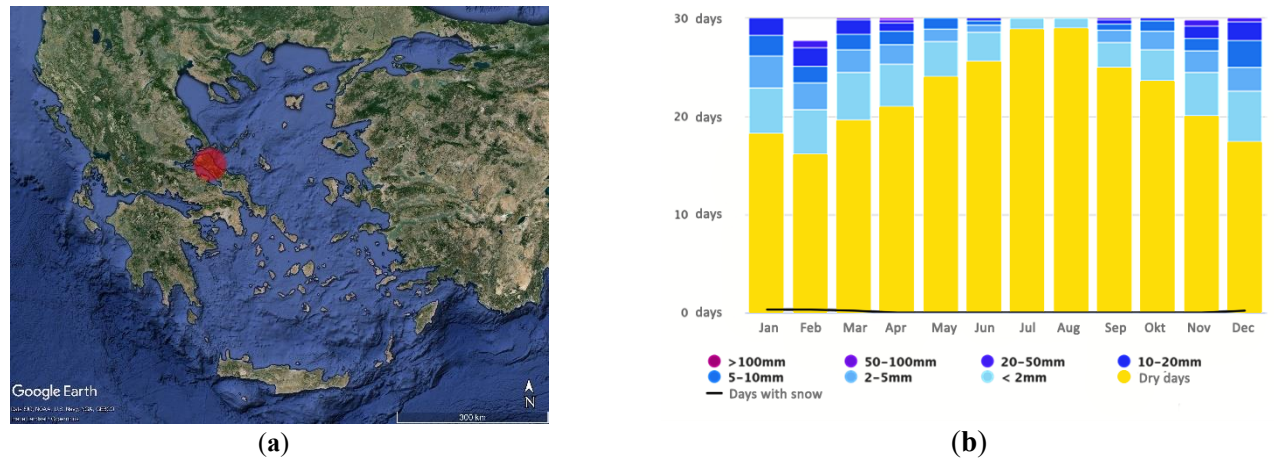
The North Euboea’s landscape is characterized by great heterogeneity in its geomorphological characteristics. The wider area is mainly covered by wild forests which contribute to the preservation of natural diversity. Also, North Euboea has numerus small rivers and tributaries [3]. Specifically, the study area of this paper focuses on the Nileas River as well as segments of the Kireas and Voudouros rivers. The climatic conditions in the wider region is temperate with distinct rainfall patterns (i.e., rainfall decreases in summer, while intense rainfall occurs between September and April) [4].
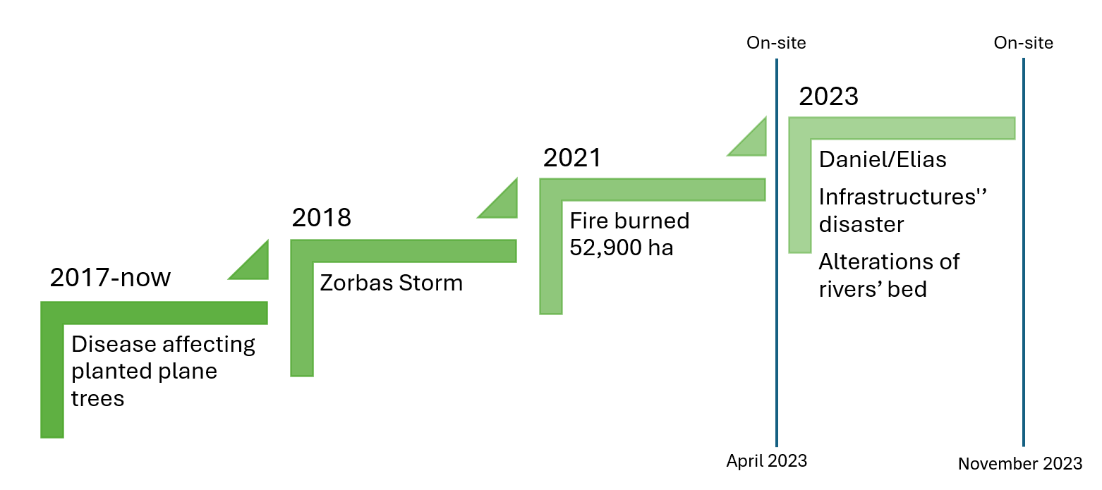
After mid-2010s, a serious disease began to wipe out planted plane trees (i.e., Platanus orientalis), which formerly flourished along riverbanks, defining the local riverscape but also defending the riverbed and supporting the stability from increased river flows during flood events. While we have not carried out research in this area, we identify the Canker stain, caused by the fungus Ceratocystis platani, as the main reason for the phytopathology of plane trees [5].
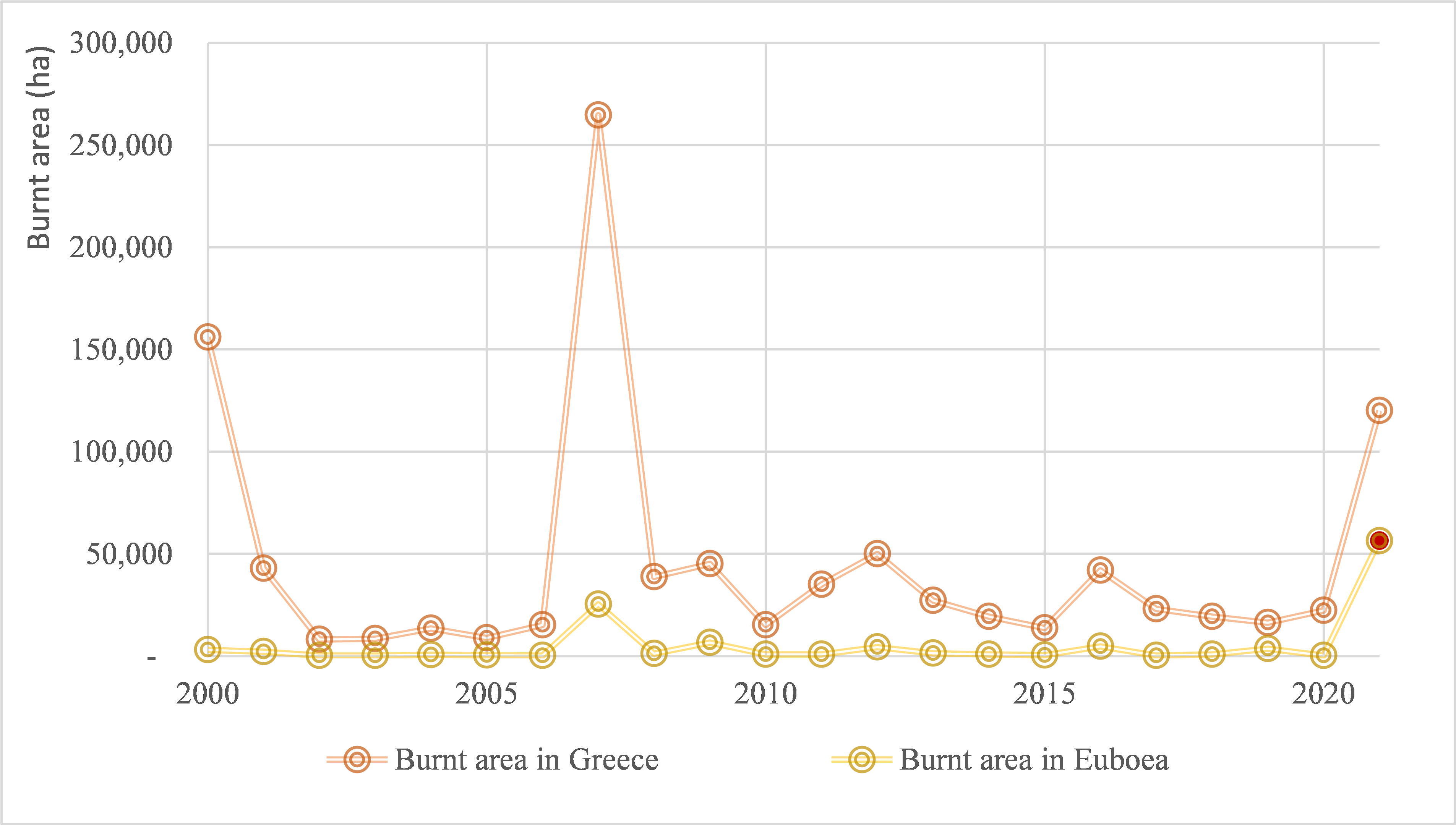
In September 2018 a strong storm (called “Zorbas” by the Greek meteorological services) hit the area [6]. In the following years, the summer of 2021 was one of the most memorably historically devastating for North Euboea. A megafire which occurred in August 2021 burned 52,900 ha in North Euboea [7] and resulted in disastrous consequences that affected the natural environment, rural landscapes, and local communities.
It is well known that changes in streamflow dynamics can be greatly affected by wildfires in several ways, such as by the increase in runoff, the alternations of the soil characteristics and of the dynamics of water yield and peak flows in forest ecosystems. Furthermore, the peak flow reactions to wildfires can also increase significantly, with the intensity of the fire and the features of the watersheds influencing these responses [8].
By noting the above, we decided to observe the vulnerability to flood risk in the Nileas River basin [9], and thus, in April 2023, we performed on-site inspections to investigate the status of the landscape after the above-mentioned destructive phenomena.
Unfortunately, the natural disasters in the area were repeated in September 2023 through the Daniel and Elias storms that hit the area and cause severe damage to villages and croplands. These events drastically changed the region’s landscape, causing various effects on the hydrological basins, and changing the morphology of the riverbeds.
We expected that these latest flood events would be revealing regarding the flood dynamics of the riverbed which has been significantly affected by modifications of both the direct flora (loss of plane [platanus] trees due to disease) and the flora of the catchment area (due to the wildfire in 2021). Therefore, following this devasting event, we performed a second follow-up on-site inspection in November 2023, to depict the status of the landscape after the occurred alterations.
In Sections 2–4 we present the methodology of our analysis, in Section 5 and in supplementary material, we present the findings from both on-site inspections and we summarize them in the discussion and the conclusions (Sections 6 and 7 respectively).
To estimate the vulnerability of the landscape in the river basin of the Nileas River, historical satellite images from Google Earth were used to estimate the effect of the disease of the plane (platanus) trees. Regarding the alterations of the flora in riverbeds in the case of floods, the potential failure estimations were also indicated.
The characteristics and the morphology of the Nileas River basin were specified and studied using GIS (Geographical Information Systems) procedures.
The first on-site inspections took place in April 2023 and after the following flood events (Daniel/Elias storms), we decided to follow up with a second on-site inspection in the Nileas River basin in November 2023 (Figure 1).
Our aim is to optimize the visual representation of changes in the catchment area in order to underline the magnitude of the changes that have occurred due to the flood events. Maps, satellite images and photographs from the on-site inspections showed us in detail the reduction of forest areas, erosion points, alterations in the riverbed and in the mouth of the river. By visualizing these changes, we can better comprehend the ever-changing landscape of a river’s floodplain and its dynamics.
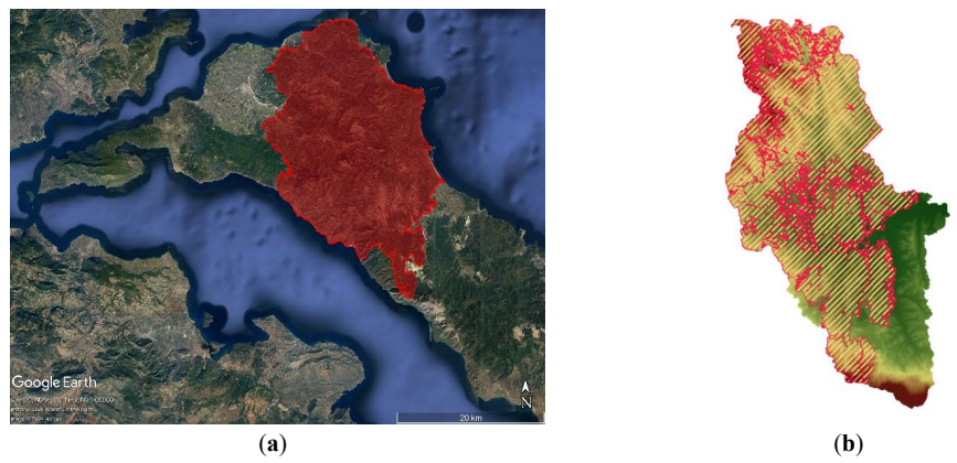
North Euboea is located in central Greece with a thriving flora and fauna (Figure 2a) and is characterized by:
The study area includes the Nileas River, and parts of the Kireas and Voudouros rivers. The region experiences a temperate climate with distinct rainfall patterns (Figure 2b), namely a decrease of rainfall is observed in the summer months, followed by an increase from September to April.
The morphological characteristics of the basin area of Nileas River (Figure 3) are summarized in Table 1 and are mainly derived from Digital Elevation Model and national databases. The river basin of Nileas River provides an overview of the geographical study area, since all hydrological processes occur inside the river basin’s boundaries. The hydrographical network illustrates the detailed river network within the Nileas River basin, including main rivers and tributaries, which is essential for analyzing how water flows and accurate flood modelling. Also, the river connectivity influences the distribution and health of flora in the riverbeds.
Both river basin and hydrographic network are derived from Digital Elevation Model following GIS procedures and then cross-checked with national geodatabases [11], The elevation curve depicts the distribution of elevations inside the Nileas River basin, which is crucial for comprehending how variations in topography influence microclimate, water flow dynamics, and, subsequently, the ecological conditions, the plant communities, and flood risks throughout the basin. Part of the land is cultivated by the locals [12].
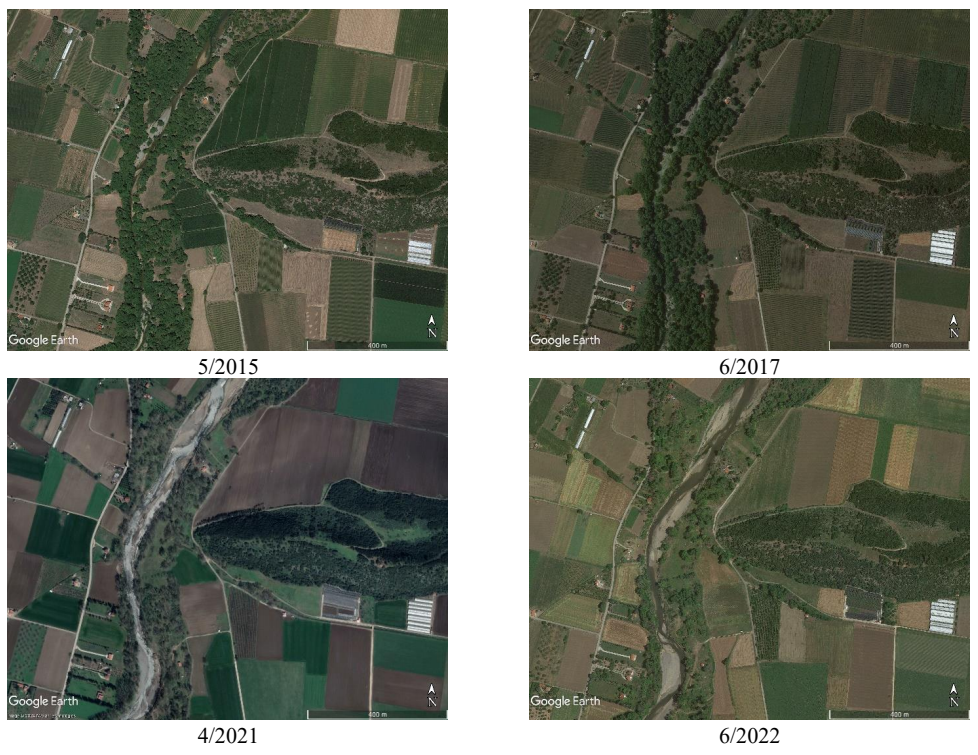
The spread of plane (platanus) tree disease and wildfires played an important role in the alterations of the landscape and the shaping of the soils’ surface. One of the most important effects was the reduction of vegetation. The vegetation had a stabilizing role for the riverbed and the formation of the soil. Τhe roots of plane trees hold the soil together and prevented erosion, while the pine trees in the forest retained the water, thus reducing the speed of its direct flow during a flash flood. With the collapse of the plane trees from the outbreak of the disease and the wildfires, the riverbed, which was initially very stable (as confirmed by the historical observations during past severe flood events), became vulnerable to erosion, causing violent alterations at the landscape and at the hydraulic roughness of the riverbed, which caused the serious changes observed during the recent flood events. In addition, the destruction of the wild forest by the megafire of 2021, disrupted the fixed drainage procedure, resulting in new drainage pathways that exacerbated the risk of flooding.
Ceratocystis platani disease is a fungus found specifically in Platanus species in the United States and Europe. In Greece, it has intruded the species Platanus orientalis resulting in a significant impact on natural forests [13]. The appearance of the disease in North Euboea is estimated to be around the mid-2010s.
In the realm of flood risk management, several significant concerns include long-lasting alterations to the landscape and vegetation in the vicinity of the river. Given that a considerable number of plane (platanus) trees thrive along riverbanks, the impact on the floodplain and river roughness coefficients has the potential to be substantial. Indeed, it has been shown that riparian trees and vegetation are essential to riverbank stabilization, while the presence of vegetation increases the roughness of the riverbed, reducing the water flow velocity. On the contrary, the elimination of riparian trees reduces the stability of the riverbanks, while the decreased roughness contributes to increased velocities, thus further increasing the vulnerability of the floodplain to erosion and increased sedimentation load [9]. Given that a considerable number of platanus trees used to thrive along riverbanks, the impact on the floodplain and river roughness coefficients has the potential to be crucial. Additionally, the likelihood of heightened sedimentation load has increased [9].
The evolution of the disease in plane trees is depicted in Figure 4 and Figure 5 and more analytically in sections 1 and 2 of the supplementary material in which is presented a detailed study on the evolution of flora in the riverbed of the Voudouros River, including comparative analyses of the riverbeds before the mid-2010s and in 2022 for the Voudouros, Nileas, and Kireas rivers.
The fertile land of Euboea is an ideal host for wild forests and wildlife. However, as the natural circle of pine tree forests is to be reborn after fire (as long as the fire does not destroy their roots in the soil), urbanization and the abandonment of the countryside may cause significant problems. At present, the inhabitants occupations and way-of-living are not linked to forest as in the past eras (e.g., for grazing goats and cattle, collecting resin of the trees, cutting trees for timber, and various other types of cultivations and livestock), and thus, the forests have arbitrary grown creating huge clusters [14] to easily act as abundant fuel material with the potential to produce megafires. This is verified by the fact that megafires in Euboea have recorded in 1977, 2007 and in 2021 [15] (Figure 6).
The effects of the 2021 wildfire, which occurred in North Euboea (Figure 7a), resulted in the decrease of the interception, increase in runoff, altered soil characteristics and roughness, and increase in stormflow volume and peak flow. In addition, other significant increases were noted, influenced by the fire intensity and watershed features.
In total, an area of 125.48 km2 was burned, while in the Nileas’ River basin, 68% of the total area was affected by the fire, impacting river flow and flood patterns (Figure 7b and Figure 8).
Cyclone Zorbas was a cyclone that hit the Mediterranean in fall of 2018. It was characterized by high intensity rainfall and subsequent severe floods, and reached its maximum intensity on 29 September [18,19].
Specifically, in North Euboea many crops and properties were destroyed due to the overflow of Kireas River. The flood due to Zorbas had a devastating impact on the whole region as well as the loss of human lives. However, the aftermath did not reveal substantial alterations in the riverbeds, highlighting the role of plane trees and the forest in the stability of the anaglyph.
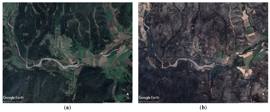
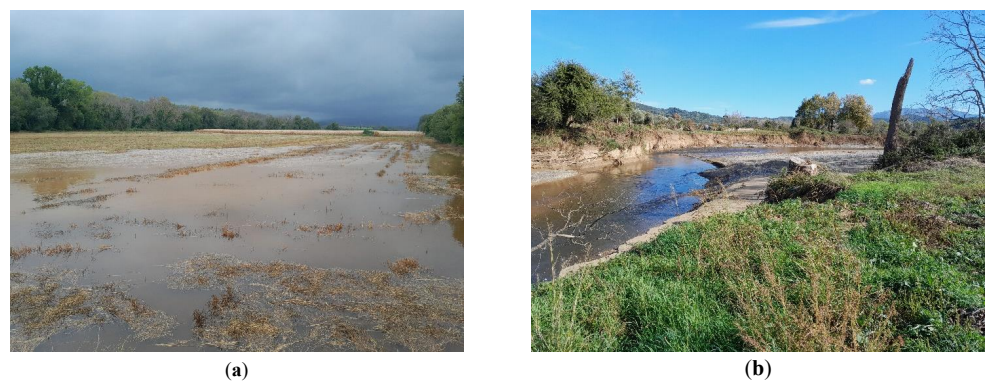
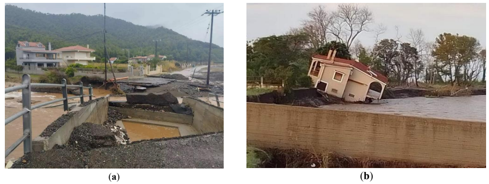
Storms Daniel and Elias occurred in September 2023 [20] and significant rainfall was reported across many Greek regions as also documented by Copernicus [21]. Cities Limni and Istiaia recorded 216 mm of rainfall in 7 h and 140 mm of rainfall in 3.5 h respectively [22,23]. Riverbed widened by Storm Elias, leading to crop destruction (Figure 9) alterations in riverbed (Figure 9b) and the collapse of civil infrastructures and private properties (Figure 10) [20].
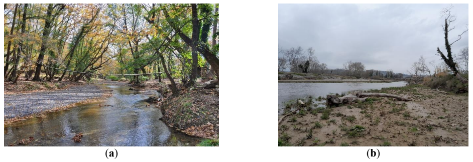
As the vulnerability of the landscape (disease of plan trees, wildfire) had been detected before the storms Daniel and Elias, we organized systematic on-field inspections [26] in April 2023, to depict the conditions of the riverbed (Figure 11). In this initial research, the dynamic of a potential catastrophe in most of the riverbed was observed, due to the disease of plane trees as, in some places, these were almost extinct. The disease appeared to have attacked the tree from the bottom of the trunk before reaching the foliage. In addition, the wildfire had also affected the areas of the rivers’ basin.
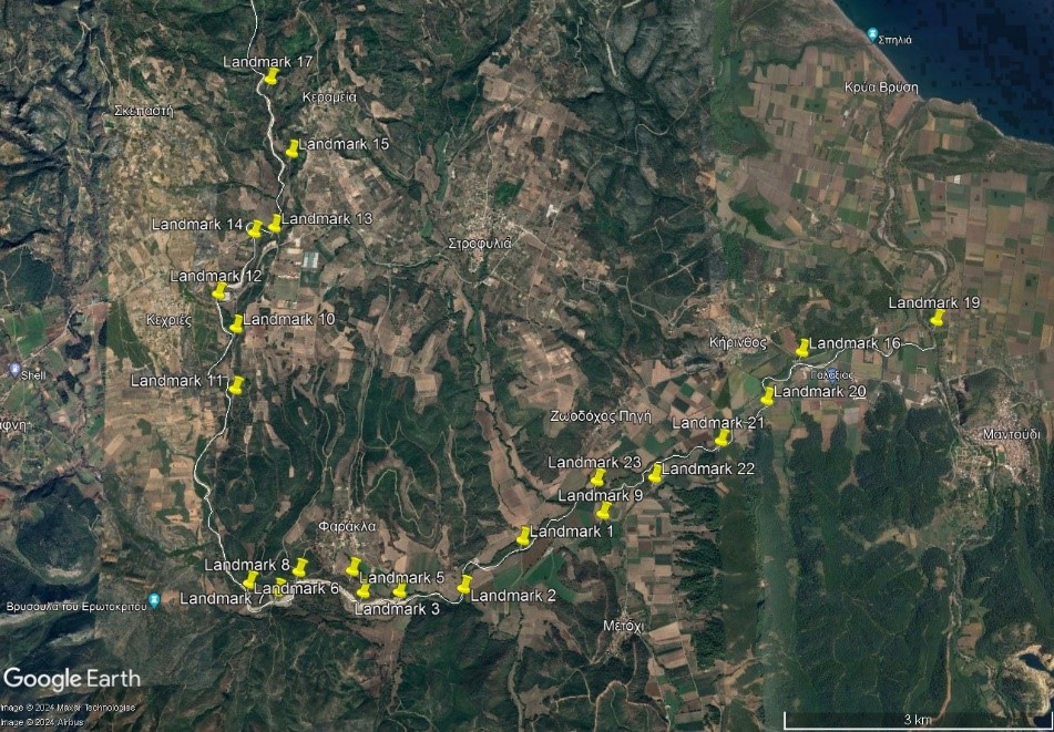
Following the on-site inspection of April and after Daniel/Elias events in September 2023, field research in November 2023 was repeated to review the landscape and observe alterations in the riverbed [27]. The primary objective of this research initiative was to gain a deeper understanding of how the environment had been affected post-flooding and to document any notable changes. The landmarks of on-site inspections were the same as those used during the April on-site field research (Figure 11) as well as a few others along Voudouros (downstream of the confluence of Kireas and Nileas) appears impressive alterations in the configuration of the landscape. An example of the on-site inspection is presented in Figure 12 and more analytical in Section 4 of the Supplementary Material.
Intense flooding phenomena pose danger to human life and social prosperity [28] and when such events happen in arable land the food security is also at risk [29,30,31].
The alteration of riverbeds creates several additional challenges for the inhabitants that are related to agriculture and thus, to the local economy. Parts of the agricultural land were swept away by the floods causing a high loss of property for locals. In addition, crops were destroyed, and in overall, the major disasters that have resulted from the events mentioned in this work had a strong impact on the local economy. On top of the direct economic impacts, the loss of arable land (the main source of income of the area), could also lead to long-term recession of the local economy. Furthermore, due to the continuous change of the landscape, the various problems that have been created in the riverbeds will not be easily mitigated as important resources and time would be required for nature-based solutions, such as trees to grow and replace the plane (platanus) trees that protected the riverbed from erosion in a natural manner through their roots that were not affected by fire events.
The relief of the landscape has changed dramatically after the natural stresses reported in the studied area, and it is possible that flood mitigation will be now difficult that could formerly be naturally absorbed with small impacts to the local community. However, it is important to get organized for the anticipation of such phenomena and the prevention of associated hazards from their effects in a timely manner, to protect the inhabitants and the environment. In this process, the knowledge and the experience of locals should also be used in order to face the potential risks [32]. Furthermore, it is also necessary to model the river, in terms of flood response, and identify weak points, which could give an updated view of the flow conditions and provide a solid foundation for proposing mitigation measures and infrastructure [33,34,35,36]. It is noted that hydraulic infrastructures also include the benefit of architectural adaptability [37,38], which can be utilized to apply architectural and landscape studies to improve their integration to landscapes and potentially also encourage tourism and other recreational activities in the area. This is possible both for any hydraulic work ranging from smaller scales in the banks to larger scales (such as dams), and similar studies can even be implemented with low additional costs and technical requirements [39]. At the same time, automatic water-monitoring networks are crucial to support early warning systems and allow authorities to take timely action [40].
Intense rainfall events are exacerbated when local landscapes were stressed by the loss of natural flora that contributed to flood mitigation. In the studied area of the Nileas riverbed in North Euboea, Greece, relevant challenges were faced due to post-wildfire loss of trees and shrubs, and the widespread disease of local plane (platanus) trees. All of the above generated the need for comprehensive risk management strategies to address flooding and infrastructure resilience in affected regions. On-site observation and the recording of alterations of the natural landscape, provided important information and helped us to understand in depth the challenges of the place.
By utilizing site visits and comparing the recorded material during the study period (before-after Daniel/Elias storm) the following observations were concluded:
The monitoring of these changes, with documentation of the initial and final state, assists in better understanding for a rational anticipation of mechanisms and dynamic alteration for many different issues to the environment and the social cohesion [41]. This is important for civil engineering as also is the study for measures of recovery.
Changes in the natural landscape are inevitable whether are caused by human factors or by natural phenomena. However, local communities, with the assistance of expert engineers, should be able to protect themselves and the environment from future disasters. The events occurred in the recent years in North Euboea, provided various points of particular interest for the interaction of natural landscape and the nature of its flora and vegetation, as impacted from various stresses in relation to the study of river flow and water management.
Further research could compare the effects caused by the storms Daniel/Elias with storm Zorbas which happened in the area in 2018 before the spread of the effects of the phytopathologies on the local populations of plane (platanus) trees, and the effects of the wildfire to the land cover by trees and shrubs in the area. In addition, as the disease is expanded in other areas, this study could be an alarm to address and take mitigation measures by constructing hydraulic infrastructures.
The following supporting information can be found at: https://www.sciepublish.com/article/pii/229, Figure S1. Study areas; Figure S2. The evolution of the disease in plain trees in area 1 of Figure S1; Figure S3. The evolution of the disease in plain trees in area 1 of Figure S1; Figure S4. The evolution of the disease in plain trees in area 1 of Figure S1; Figure S5. The evolution of the disease in plain trees in area 1 of Figure S1; Figure S6. The riverbed before mid-2010s and in 2022 in Voudouros, Nileas and Kireas rivers; Figure S7. The riverbasin of Nileas river in August 2020 (before the wildfire) (Source: GoogleEarth); Figure S8. The river basin of Nileas river in August 2021 (after the wildfire) (Source: GoogleEarth); Figure S9. Nileas River-Branch of Interest (Source: GoogleEarth); Figure S10. River elevation profile (Source: GoogleEarth); Figure S11. Additional Points (Source: GoogleEarth); Table S1. Landmarks which present before and after Daniel and Elias storms; Table S2. Landmarks which were added in the second phase.
The authors would like to thank Eleonora Tounousidou, Spiros Kagelaris and Christos Christodoulou from Greek Land Registry (ΕΛΛΗΝΙΚΟ ΚΤΗΜΑΤΟΛΟΓΙΟ), for providing them the geospatial data of the area. They also like to thank Apostolos Balatsos, Giorgos Zigomitros and Antonios Moschou for the valuable insights and their support in the field research.
Not applicable.
This research received no external funding but was motivated by the scientific curiosity of the authors.
The authors declare that they have no known competing financial interests or personal relationships that could have appeared to influence the work reported in this paper.