1. Introduction
Agriculture is a cornerstone of global food security, yet it faces increasing challenges due to rising food demands, climate change, and resource scarcity. By 2050, the world’s population is projected to reach 9.7 billion, requiring a 70% increase in agricultural production while minimizing environmental impact [
1,
2]. Water scarcity, soil degradation, and unpredictable weather patterns threaten agricultural sustainability, particularly in semi-arid regions such as Tunisia [
3,
4,
5]. In response, innovative solutions such as precision agriculture have emerged, integrating advanced technologies to optimize farming practices and resource management.
Drones, also known as Unmanned Aerial Vehicles (UAVs), have transformed agricultural monitoring by enabling high-resolution imaging, real-time data collection, and cost-effective precision farming solutions. Unlike traditional methods such as satellite imagery, drones offer superior spatial resolution, greater flexibility in deployment, and the ability to operate in diverse weather conditions [
6]. Their applications in agriculture range from monitoring crop health and detecting early signs of diseases, water stress, and nutrient deficiencies to optimizing irrigation management by identifying dry zones and ensuring efficient water distribution [
7]. They are also widely used for soil and field analysis, helping to generate detailed topographic maps that enhance land preparation [
8]. Additionally, drones assist in the early detection of pests and weeds through multispectral data, allowing farmers to take preventive measures before visible symptoms appear [
9]. Yield prediction and assessment further benefit from drone technology, as growth trends can be analyzed to support informed decision-making [
10].
The efficiency of UAVs in precision agriculture is largely attributed to their advanced sensor technology. RGB cameras provide high-resolution imagery for visual inspection and mapping, while multispectral sensors allow for detailed vegetation analysis through indices such as the Normalized Difference Vegetation Index (NDVI), which is commonly used to assess plant health [
11].
UAVs have increasingly been used in precision agriculture for vegetation monitoring and crop management. Recent studies highlight the advantages of multispectral imaging for early crop stress detection and input optimization [
12]. Indeed, thermal sensors further enhance monitoring by detecting variations in temperature, making them valuable for assessing water stress and irrigation efficiency [
4]. Optimizing UAV flight settings is crucial for obtaining reliable vegetation indices and enhancing decision-making in precision agriculture. Research on UAV flight altitude and NDVI estimation confirms that factors like time of day and solar zenith angle play a key role in data accuracy [
13]. On the other hand, LIDAR sensors, capable of generating three-dimensional terrain models, contribute to more accurate land surveys and improved agricultural planning [
3].
In Tunisia, where agriculture plays a critical role in the economy and food security, drone technology presents an innovative approach to addressing key agricultural challenges. Despite its potential, research on UAV integration in Tunisian agriculture remains limited [
5,
14,
15]. While some pilot projects have explored drone-assisted irrigation management, comprehensive studies focusing on their full-scale application in precision agriculture are lacking. This gap is particularly evident in Sidi Bouzid, a region where agricultural productivity is threatened by water scarcity, soil degradation, and climate variability [
1].
This study explores the role of drone technology in precision agriculture in Sidi Bouzid, emphasizing its impact on crop yield optimization, plant health assessment, and resource management. The research employs REMO-M professional drones equipped with RGB and multispectral sensors, chosen for their ability to capture high-resolution images and analyze vegetation health with precision. By integrating UAV technology with geospatial analysis, the study aims to improve agricultural decision-making and promote more sustainable farming practices.
The research focuses on three main objectives. The first involves optimizing water management by utilizing NDVI assessments and watershed analysis to improve irrigation efficiency and minimize water loss [
2]. The second seeks to enhance crop health monitoring through spectral analysis, enabling early detection of plant diseases, water stress, and nutrient imbalances [
15]. The third objective addresses sustainable resource management by applying geospatial data analytics to refine nitrogen fertilization strategies, reducing excessive inputs while maximizing productivity [
16].
By leveraging drone-based monitoring, this study provides a data-driven approach to precision agriculture, offering solutions that can be adapted to similar semi-arid agricultural regions. The findings contribute to the broader adoption of UAV technology in Tunisia and serve as a replicable model for integrating advanced agricultural technologies in areas facing environmental and resource management challenges.
2. Materials and Methods
2.1. Study Area
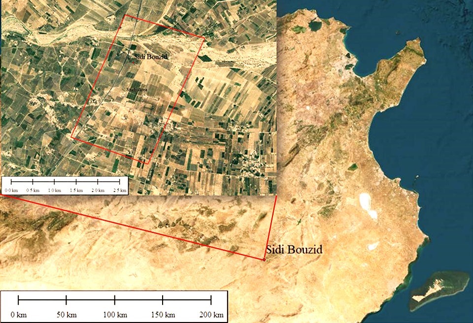
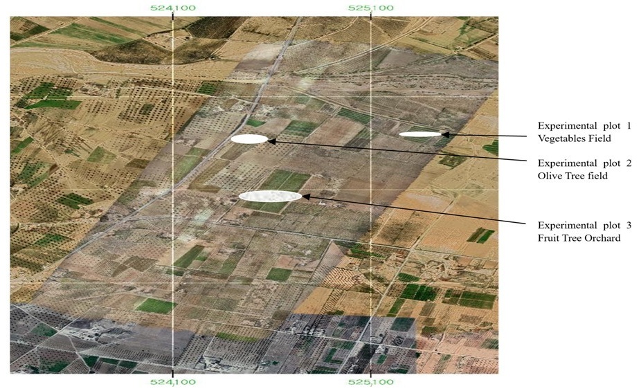
The study was conducted in Sidi Bouzid, Tunisia, a region characterized by a semi-arid climate with irregular rainfall patterns and significant agricultural challenges, including water scarcity and soil degradation. The selected area covers 4.78 km
2 ().
This area includes diverse crop types such as vegetables, fruit trees, and olive groves, which are essential to local agriculture ().
Given the region’s vulnerability to climate variability and overexploitation of water resources, the implementation of drone-based precision agriculture represents a challenge to optimizing irrigation, monitoring crop health, and improving overall agricultural productivity.
. The study area in Sidi Bouzid, Tunisia.
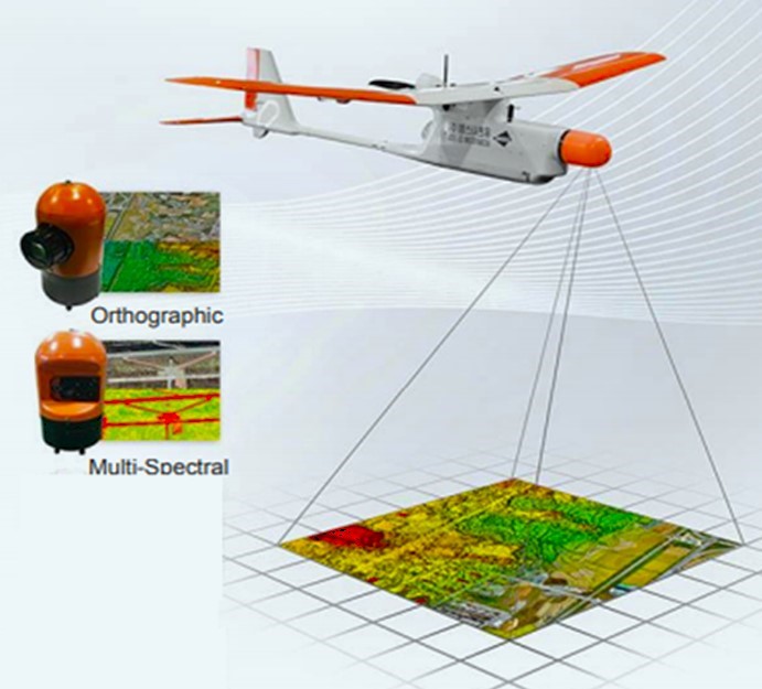
To achieve high-resolution agricultural monitoring, this study employed the REMO-M professional drone (), a fixed-wing UAV designed for precision mapping. The choice of REMO-M was based on its high payload capacity, extended flight endurance, and ability to capture high-resolution multispectral and RGB imagery, which are essential for vegetation analysis and resource management.
Advanced UAV systems now integrate deep-learning-based sensing and actuator fault-tolerant control to enhance operational reliability in agricultural environments [
11].
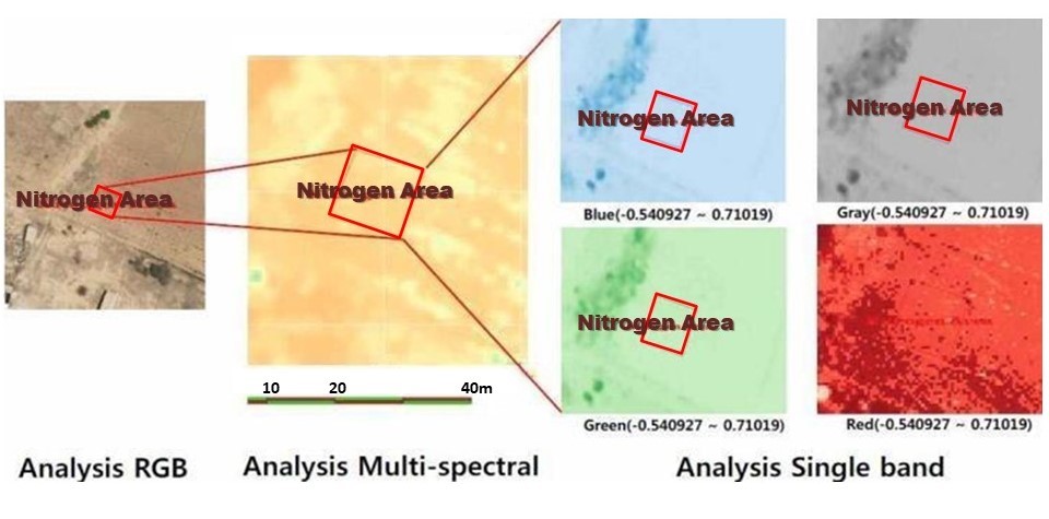
The REMO-M drone was equipped with a 20.4-megapixel RGB camera and a multispectral sensor array that included five narrow-band sensors capturing Red Edge and Near-Infrared (NIR) wavelengths. The RGB sensor provided high-resolution imagery for visual assessment and mapping, while the multispectral sensor was used to calculate the Normalized Difference Vegetation Index (NDVI), a widely used metric for evaluating plant health, chlorophyll content, and crop stress [
17].
The drone’s flight planning and obstacle avoidance system were configured to ensure optimal data collection. Flights were conducted at an altitude of 120 m, following a predefined grid pattern to ensure complete coverage of the study area [
13]. The flight path was planned using Pix4Dcapture 4.0, software, integrating ground control points (GCPs) to enhance geospatial accuracy. The collected images were georeferenced and processed immediately after each flight.
. The REMO-M Imaging System.
After data acquisition, images were processed using Pix4DMapper and QGIS software to generate georeferenced ortho-mosaics, Digital Surface Models (DSM), and NDVI maps. The workflow involved the following steps:
- -
-
Radiometric Calibration: A calibration panel with predefined reflectance values was used to correct sensor biases and ensure consistent spectral readings across different flights ().
- -
-
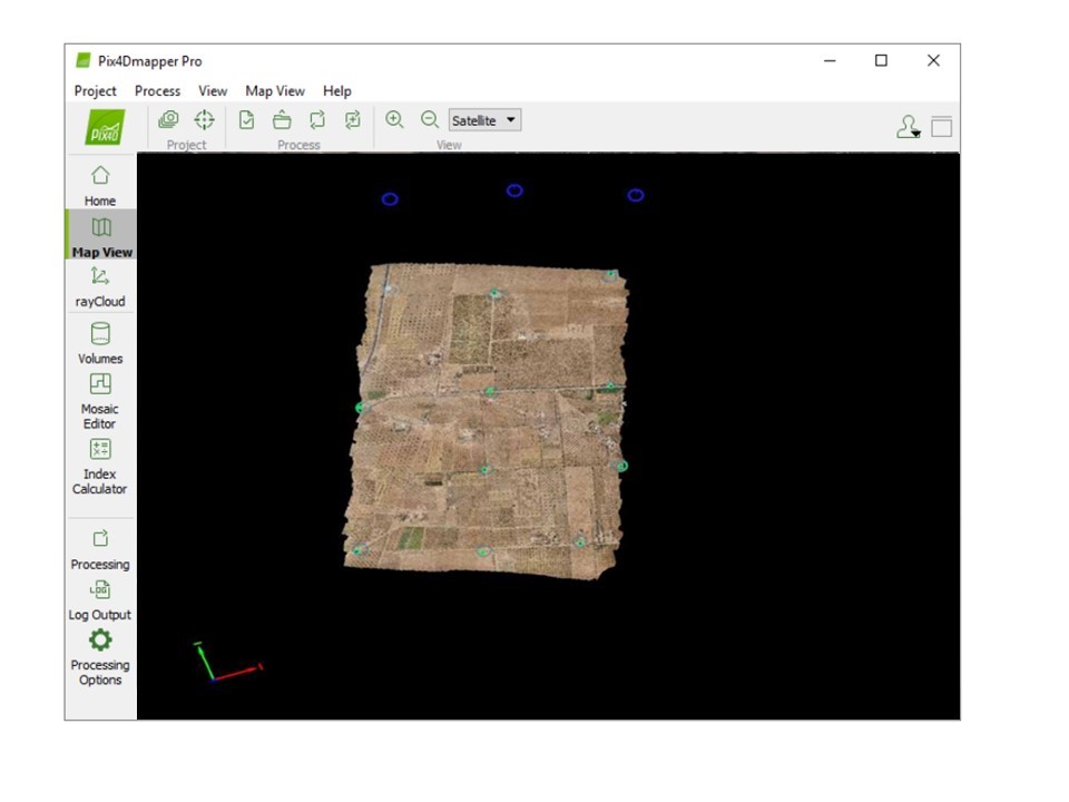
Image Alignment and Georeferencing: Pix4D identified common features across multiple images, aligning them to enhance spatial accuracy (). Ground Control Points (GCPs) were incorporated to improve geospatial precision [18].
- -
-
Generation of Point Cloud and 3D Models: A sparse point cloud was initially created, followed by a dense point cloud to construct Digital Elevation Models (DEM) and Digital Terrain Models (DTM).
Figure 4. Multispectral camera calibration tools.
. Pix4DMapper Processing RGB.
After finishing these steps, a sparse point cloud was created initially, followed by the construction of a dense point cloud representing the surveyed area.
The final step involved generating georeferenced ortho-mosaics, Digital Surface Models (DSM), and Digital Terrain Models (DTM), which served as critical outputs for subsequent analyses.
Once processed, these geospatial products were exported in various formats suitable for further analysis in QGIS 3.10 software.
2.4. NDVI Calculation
The NDVI was computed using the raster calculator function in QGIS using the standard formula:
This calculation enabled the assessment of vegetation health across all experimental plots, providing insights into crop vitality and stress levels ().
This index was used to assess crop health, identifying areas experiencing water stress, nutrient deficiencies, or disease.
. NDVI calculation steps: band raster selection (<b>a</b>) and the NDVI equation (<b>b</b>).
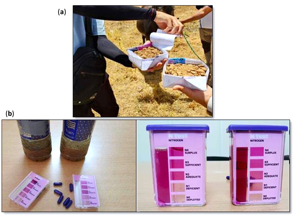
Ground-truthing was conducted to validate the accuracy of drone-based assessments. Field measurements were taken at multiple locations, comparing NDVI results with chlorophyll content analysis and soil nutrient testing. A controlled nitrogen fertilization experiment was also performed:
- -
-
A 100 m2 experimental plot was divided into fertilized and non-fertilized sections.
- -
-
Soil samples were analyzed using a colorimetric nitrogen test, classifying nitrogen levels into four sufficiency categories (N1–N4).
A follow-up drone flight two months post-fertilization captured NDVI data, evaluating the impact of nitrogen application on plant health ().
. Sampling (<b>a</b>) and Nitrogen density test (<b>b</b>).
In addition to NDVI evaluations, watershed analysis was conducted using GIS tools to assess water distribution across the study area. Hydrological modeling techniques were applied to identify drainage patterns, potential erosion hotspots, and areas at risk of overexploitation. These insights contributed to optimizing irrigation strategies, ensuring efficient water use in precision agriculture.
2.7. Data Analysis
The integrated multi-temporal and multi-sensor data were analyzed using advanced GIS techniques alongside statistical software packages. Spatial analyses included land use classification based on NDVI values, temporal assessment of crop health dynamics, and correlation analysis between NDVI results and field-measured nitrogen levels.
This comprehensive methodology enabled a multi-faceted assessment of crop health, land use patterns, and the effectiveness of precision agriculture interventions using drone-based remote sensing in the semi-arid agricultural context of Sidi Bouzid, Tunisia. The approach allowed for the generation of actionable insights to optimize agricultural practices and resource management in the region.
3. Results
This section presents the findings from the drone-based assessments conducted in Sidi Bouzid, Tunisia, focusing on spatial information analysis and NDVI evaluations. The results highlight the efficiency of drone technology in monitoring agricultural health and optimizing resource management.
3.1. Spatial Information Analysis
Drone-based remote sensing provided a detailed spatial overview of the study area, offering high-resolution insights into land use, crop distribution, and resource management. By integrating UAV-derived ortho-mosaics, Digital Surface Models (DSM), Digital Terrain Models (DTM), and land use classification maps, the study enabled precise geospatial analysis critical for precision agriculture.
3.1.1. Ortho-Mosaic Processing
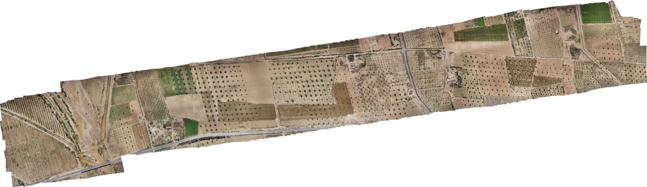
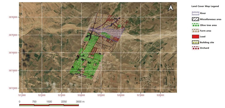
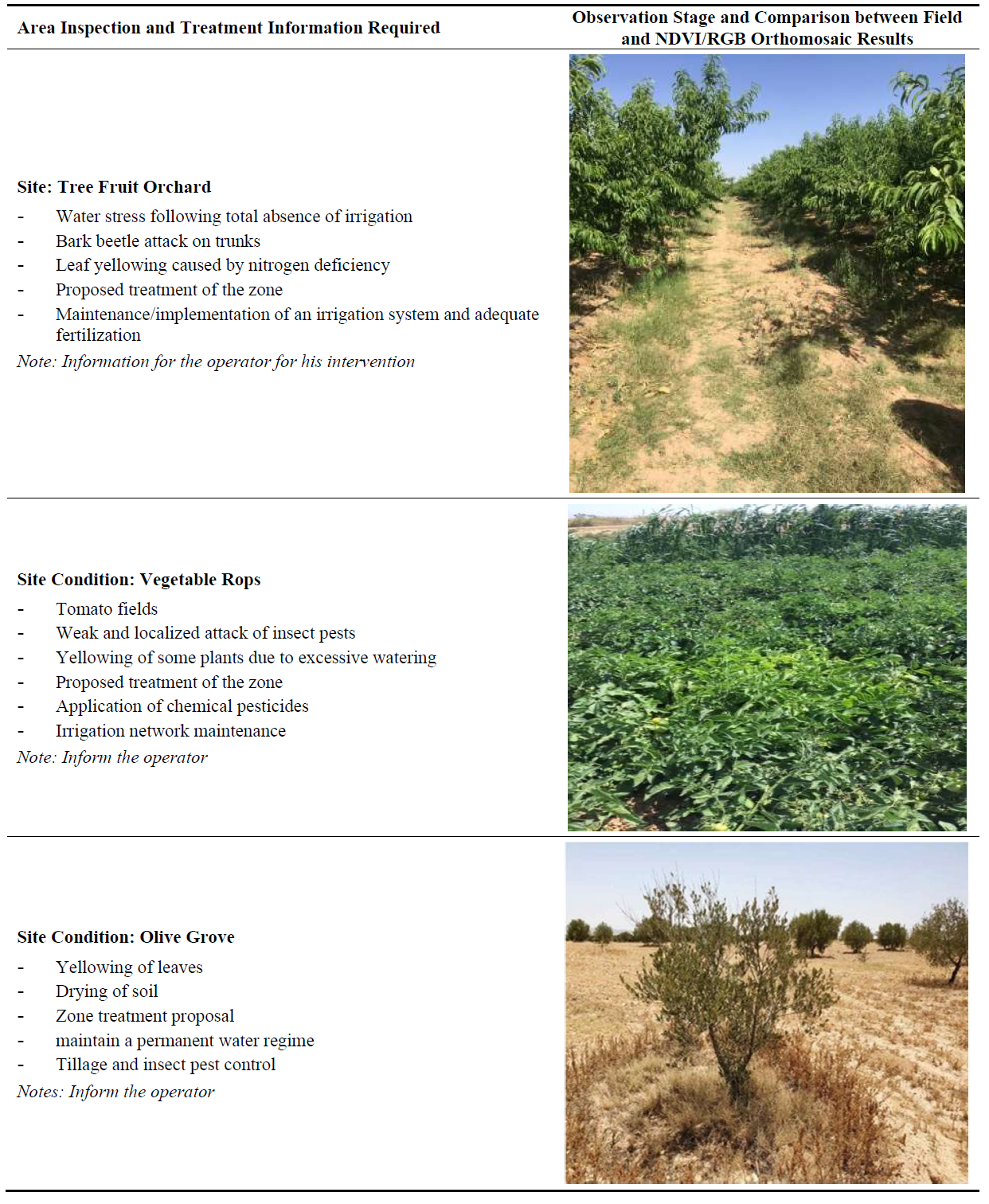
The high-resolution ortho-mosaic generated from RGB imagery provided a comprehensive visual representation of the study area. The land use classification revealed three primary agricultural zones: olive groves, fruit orchards, and vegetable fields. The spatial analysis distinguished between irrigated and non-irrigated zones, highlighting variations in crop density and soil conditions ().
. Ortho mosaic processing.
Compared to traditional land surveying methods, drone-assisted mapping offers a higher level of spatial accuracy and real-time data collection capabilities. Traditional methods rely on manual ground surveys, which are time-consuming, labor-intensive, and prone to inaccuracies. In contrast, UAV-based mapping enables rapid, large-scale assessment, improving decision-making for precision irrigation, soil treatment, and crop rotation strategies. These findings align with previous studies that have demonstrated the efficiency of drone-based remote sensing in agricultural land classification [
6,
9].
3.1.2. Spectral Classification and Crop Differentiation
Beyond NDVI, multispectral classification was applied to distinguish different crop types within the study area. By analyzing spectral signatures, the drone imagery facilitated precise crop classification, separating olive trees, fruit orchards, and vegetable fields based on their distinct spectral reflectance patterns ().
. Multi-spectral processing analysis.
This classification allowed for better crop management decisions, particularly in optimizing fertilization schedules, pesticide application, and irrigation distribution based on crop-specific needs. Studies have demonstrated that UAV-based spectral classification significantly enhances the accuracy of crop identification and yield prediction compared to traditional field surveys [
7,
16].
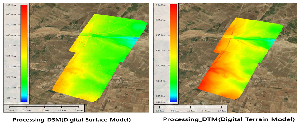
3.1.3. Digital Surface Model (DSM) and Digital Terrain Model (DTM)
The DSM and DTM maps generated from UAV imagery provided a three-dimensional perspective of the study area, capturing elevation changes, terrain structures, and watershed dynamics (). The DSM identified critical elevation variations, revealing low-lying areas prone to water accumulation and erosion risks. The DTM further refined the hydrological analysis, contributing to water resource management and topographic planning.
By incorporating DSM and DTM models, farmers and land managers can optimize irrigation networks by directing water flow toward high-risk drought zones while preventing excess runoff in low-lying areas. Similar research has demonstrated that DSM-based hydrological modeling enhances precision irrigation planning in semi-arid environments [
3].
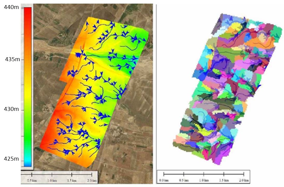
3.1.4. Watershed Analysis
The watershed analysis, performed using GIS-based hydrological modeling, provided valuable insights into the region’s hydrology by identifying key drainage patterns, water retention zones, and areas susceptible to soil erosion. The study revealed significant spatial variations in runoff distribution, with certain plots experiencing heightened water stress due to insufficient drainage infrastructure ().
. Watershed analysis: Linear stream network (blue lines) and colored sub-watersheds (polygon areas).
By pinpointing flood-prone areas and zones suffering from water deficits, the analysis offers actionable recommendations for implementing precision irrigation systems. Effective watershed management is especially critical in semi-arid regions like Sidi Bouzid, where irregular rainfall patterns exacerbate water scarcity challenges. These findings are consistent with prior hydrological research, which underscores the importance of GIS-based modeling in enhancing irrigation planning and promoting sustainable water resource management [
19].
3.1.5. Topographic Mapping
The topographic maps generated from UAV data illustrated field gradients, soil texture distribution, and landscape features. These maps serve as essential tools for agricultural planning, ensuring that land preparation, irrigation, and fertilization strategies are tailored to site-specific conditions ().
. Topographic mapping of the study area.
By integrating topographic mapping into precision agriculture, land managers can optimize tillage practices, soil conservation efforts, and crop placement to reduce erosion risks and improve productivity. This approach aligns with findings from previous studies on UAV-assisted topographic assessments for precision farming [
8].
3.1.6. Flood Risk Assessment and Soil Erosion Detection
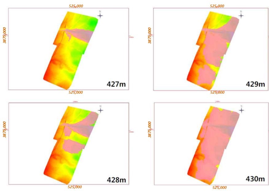
The study further analyzed flood-prone areas and erosion hotspots using topographic mapping and soil stability analysis. Contour maps were utilized to highlight subtle elevation differences (427–430 m), aiding in the prediction of water flow behavior during extreme weather events. By integrating slope analysis, a Soil Erosion Risk Index was developed, identifying vulnerable areas that require protective land management strategies ().
. Flooding risk and soil erosion analysis: Elevation ranges (427–430 m) with identified vulnerable zones.
Additionally, UAV-based assessments provided precise, up-to-date data on flood and erosion risks, enhancing the accuracy of land conservation planning. Prior research has demonstrated that remote sensing techniques, such as UAV imagery, significantly improve soil erosion modeling and support sustainable land management in drought-prone regions [
15,
16].
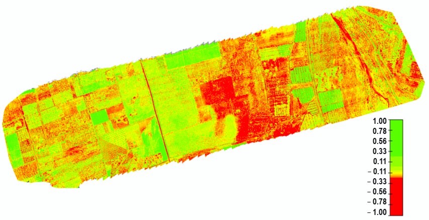
3.2. NDVI Analysis
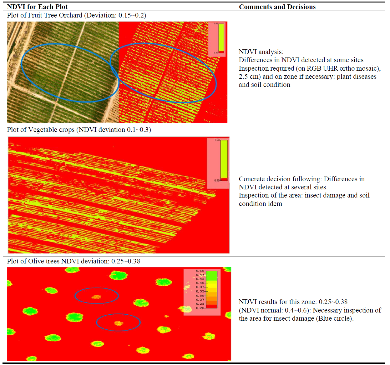
The Normalized Difference Vegetation Index (NDVI) analysis revealed clear variations in crop health and vigor across different plots. The NDVI values ranged between 0.15 and 0.38, with higher values indicating healthy vegetation and lower values signaling water stress, nutrient deficiencies, or pest infestations.
3.2.1. NDVI Analysis for Olive Trees
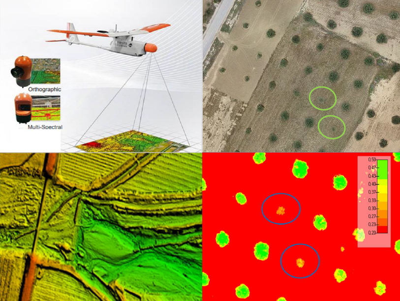
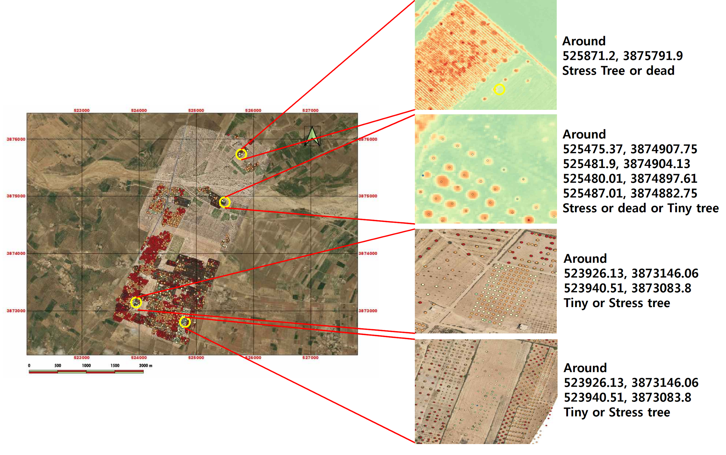
The NDVI results for olive groves indicated that the majority of trees exhibited moderate to high NDVI values (0.25–0.38), suggesting relatively good health. However, localized areas with lower NDVI (<0.2) were identified, correlating with drier soil conditions and signs of water stress ().
Figure 14. NDVI Analysis for Olive groves.
The NDVI analysis provided valuable insights for crop management, enabling farmers to make data-driven decisions in real time to optimize irrigation, fertilization, and overall field management ().
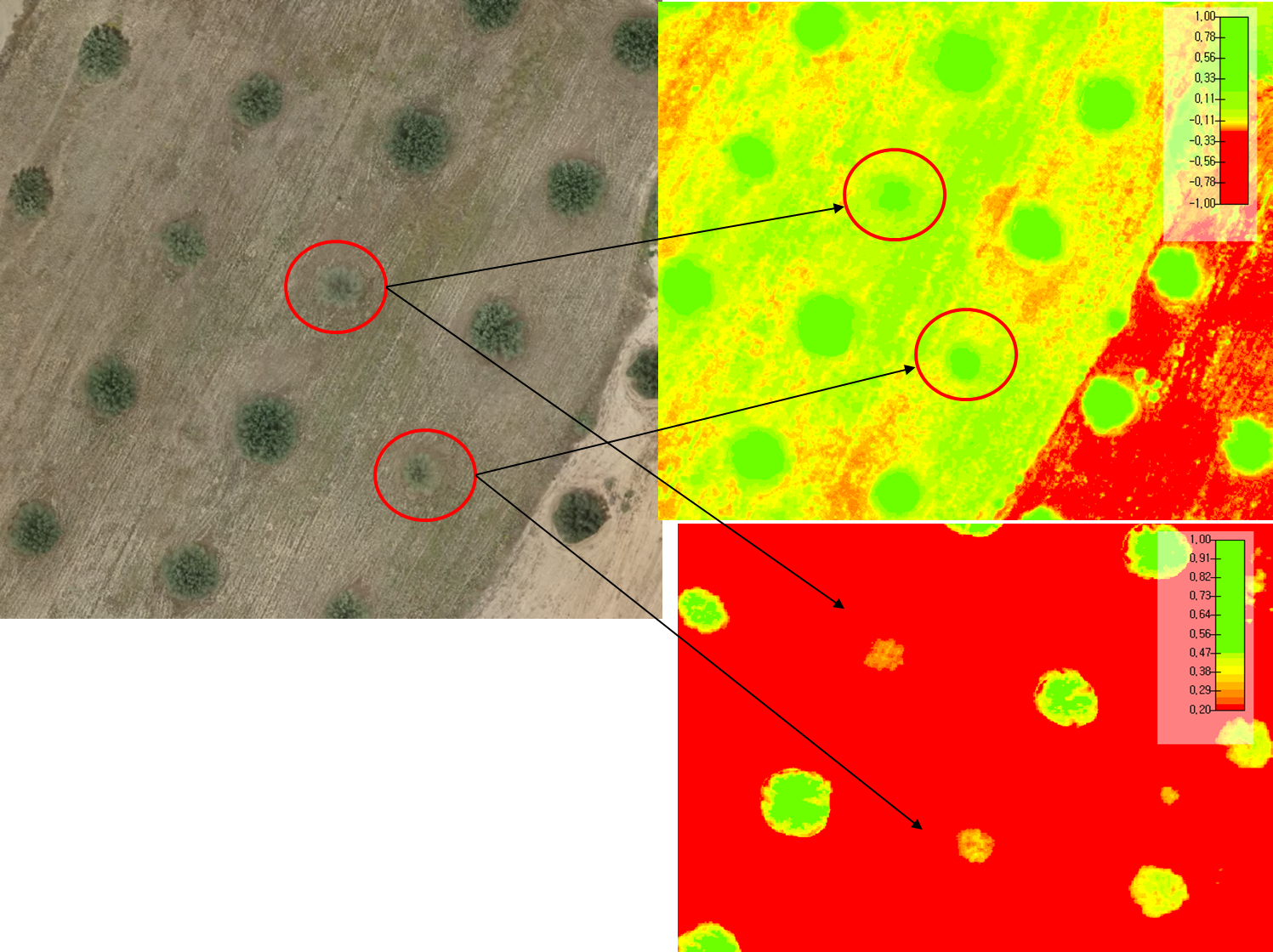
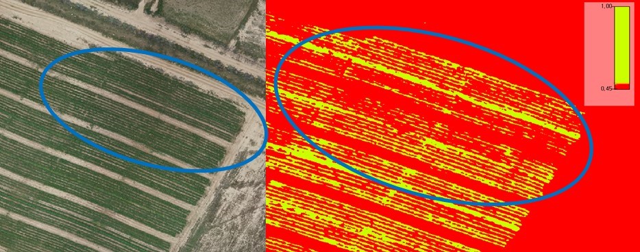
. NDVI For the plot of olive trees: Data comparison Analysis on Olive Tree’s health.
The provided figure presents a comparative NDVI analysis of an olive tree plot using three different visual representations:
- -
-
RGB Image (Top Left): Displays the olive trees in their natural colors. The red circles highlight trees showing visible signs of stress, such as reduced canopy density.
- -
-
NDVI Map (Top Right): Uses a color scale to represent vegetation health: Green areas indicate healthy vegetation. Yellow to red areas suggest stress, low vegetation, or bare soil. The marked trees have lower NDVI values, confirming potential stress.
- -
-
Thresholded NDVI Classification (Bottom Right): A binary segmentation where Green shades represent high NDVI values (healthy vegetation) and Red shades indicate low NDVI values (stressed or sparse vegetation). The stressed trees are clearly isolated, making it easier to pinpoint problem areas for intervention.
The NDVI analysis validates the visible signs of stress detected in the RGB image. These trees might require targeted interventions, such as adjusted irrigation, soil amendments, or pest management.
The combination of NDVI and visual inspection provides actionable insights for precision agriculture, allowing farmers to optimize resource use and improve tree health.
Before the use of drones, such variability in tree health was not easily detectable through traditional field inspections. The drone-enabled NDVI assessment allowed for targeted intervention in stressed areas, leading to more efficient irrigation and soil management strategies. The NDVI analysis revealed significant variations in vegetation health across different plots, highlighting areas with water stress and nutrient deficiencies. Recent research has demonstrated the effectiveness of UAV-based multispectral imaging combined with machine learning in mapping water stress in orchard crops [
12].
3.2.2. NDVI for Fruit Orchard
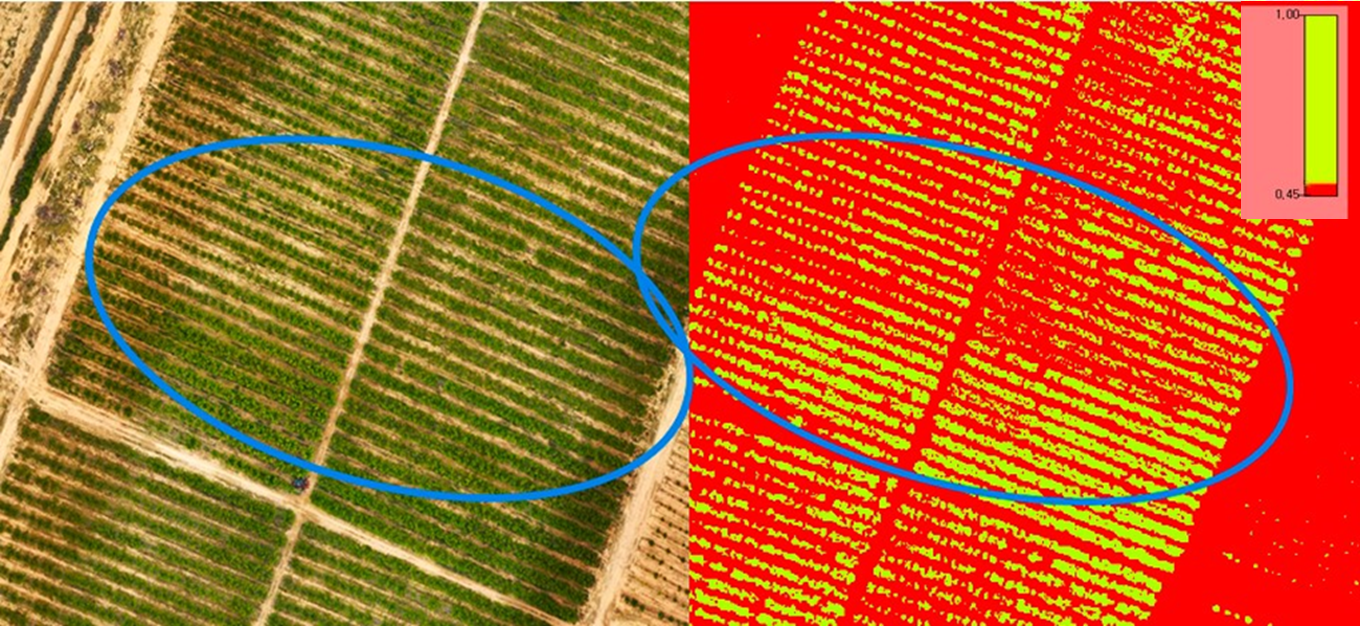
The NDVI analysis for fruit orchards revealed variations in plant health across the study area. The NDVI values ranged from 0.15 to 0.4, indicating differences in vegetation vigor and possible stress conditions. Areas with NDVI values below 0.2 corresponded to trees exhibiting signs of water stress and nutrient deficiencies, while zones with values above 0.35 indicated healthy and well-irrigated trees with strong vegetative growth. ().
. NDVI For the fruit orchard.
A comparative assessment with ground observations confirmed that areas with lower NDVI values exhibited leaf yellowing and reduced canopy densities, which were attributed to irregular irrigation and limited soil nutrients. On the other hand, higher NDVI zones corresponded to sections where trees had adequate soil moisture and balanced fertilization.
The NDVI mapping enabled the identification of localized problem areas, allowing for targeted interventions such as adjusting irrigation schedules and improving soil nutrient management. These findings align with previous research that highlights UAV-based NDVI as an effective tool for monitoring orchard health and optimizing agricultural inputs.
3.2.3. NDVI for Vegetable Crops
The NDVI analysis for vegetable crops showed more pronounced variability, with values ranging from 0.1 to 0.35. Unlike the fruit orchards, vegetable fields displayed a wider range of vegetation health conditions, reflecting differences in crop maturity stages, nutrient availability, and soil moisture levels ().
. NDVI For the second plot of vegetable crops.
The area with NDVI values below 0.15 corresponded to weaker plant development and visible signs of stress, which ground inspections confirmed were caused by excessive irrigation in certain plots and inadequate watering in others. In contrast, higher NDVI values between 0.25 and 0.35 were observed in areas where crops displayed optimal growth, darker green foliage, and uniform plant density.
The ability to distinguish between healthy and stressed zones within the vegetable plots provided valuable insights for improving irrigation precision and fertilizer application strategies. By adjusting water distribution according to NDVI readings, farmers can prevent overwatering, reduce soil nutrient leaching, and optimize crop yield.
3.3. Impact of Nitrogen Application
A comparative analysis of fertilized versus non-fertilized plots provided experimental validation of the role of nitrogen application in crop health improvement. The NDVI values for the fertilized plot increased from 0.22 to 0.36, indicating better chlorophyll content and improved plant vigor ().
. NDVI before and after nitrogen application.
Soil tests confirmed higher nitrogen concentrations in fertilized zones, validating the effectiveness of targeted precision fertilization in enhancing soil fertility and reducing excessive input applications. These findings align with previous studies highlighting the benefits of precision nitrogen management using UAV-assisted monitoring.
3.4. Observations and Benefits
The integration of UAV technology into agricultural monitoring provided several key benefits, enabling high-resolution crop monitoring, data-driven decision-making, and sustainability insights:
3.4.1. Enhanced Crop Monitoring
The ability to capture high-resolution imagery facilitated early detection of crop health issues, allowing for timely interventions. The NDVI results identified spatial variations in vegetation health, guiding site-specific corrective actions ().
3.4.2. Data-Driven Decision Making
The combination of spatial analysis, NDVI evaluations, and geospatial modeling provided actionable insights for agronomic practices. These findings supported precision irrigation strategies, targeted fertilization plans, and pest control measures ().
. Results of Qualitative and Quantitative Survey.
3.4.3. Sustainability Insights
By identifying areas at risk of resource overexploitation, soil degradation, or water stress, this research contributes to sustainable agricultural practices. The application of multispectral analysis enabled efficient resource allocation, ensuring minimal environmental impact with minimal chemical treatment application.
3.5. Analysis of Results
The results obtained from NDVI assessments, nitrogen application studies, and spatial analysis revealed strong correlations between vegetation health, soil conditions, and water availability across the plots. These findings offer insights into the factors influencing crop growth and highlight the potential for precision agriculture interventions.
3.5.1. NDVI-Based Crop Health Evaluation
NDVI analysis revealed clear variations in vegetation health, with gradients from light to dark green indicating differences in chlorophyll content and plant vitality.
-
-
Olive trees showed moderate NDVI values (0.25–0.38), with lower values in areas experiencing water stress, suggesting sensitivity to moisture availability.
-
-
Fruit orchards exhibited greater NDVI variability, linked to irrigation efficiency and tree age, with younger or poorly irrigated orchards showing lower NDVI values.
-
-
Vegetable crops had the lowest NDVI values (0.1–0.3), highlighting their higher sensitivity to both nutrient and water availability ().
3.5.2. Impact of Nitrogen Application
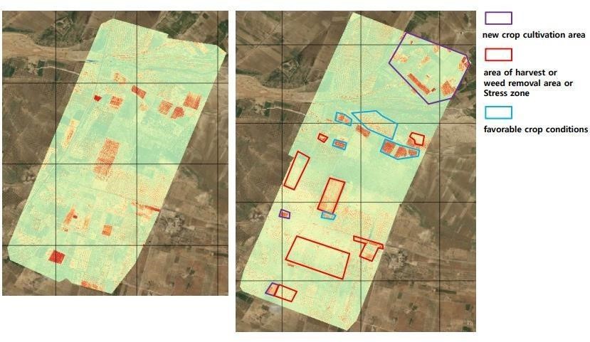
Post-application NDVI analysis showed a significant improvement in plant health in fertilized plots (N4 level) compared to unfertilized plots (N3 level), indicating that targeted nitrogen application enhanced chlorophyll content and overall crop vigor ().
. Comparison between the first and second full inspection.
3.5.3. Hydrological Insights and Land Management
Watershed analysis revealed uneven water distribution, affecting crop growth across the plots:
-
-
Low-lying areas retained more water, increasing the risk of waterlogging and soil erosion.
-
-
Higher elevation regions exhibited better drainage, leading to higher NDVI values and healthier crops ().
These findings emphasize the importance of adaptive water resource management, optimizing irrigation, and reducing erosion risks to improve crop health and productivity.
The results highlight the need for integrated management practices, including efficient irrigation, targeted fertilization, and proper land management, to enhance crop health and sustainability. UAV-based NDVI analysis is an invaluable tool for real-time monitoring, enabling farmers to make informed decisions that promote agricultural productivity and environmental sustainability in the Sidi Bouzid region.
4. Discussion
The integration of UAV-based monitoring, NDVI analysis, and geospatial data processing provided significant insights into crop health, soil fertility, and water resource management. This study demonstrated that drone-assisted precision agriculture enhances decision-making by providing real-time, high-resolution data, leading to more efficient agricultural practices.
4.1. NDVI-Based Crop Health Monitoring
The NDVI analysis provided a quantitative assessment of vegetation health across different crop types, highlighting variations in plant vigor, water availability, and soil conditions. The observed NDVI values ranged from 0.1 to 0.5, with distinct patterns among olive trees, fruit orchards, and vegetable crops.
presents a comparative summary of NDVI values recorded for the studied crops, demonstrating differences in plant response to environmental factors ().
. NDVI Values for Different Crop Type.
The results revealed the following trends:
- -
-
Olive trees displayed moderate NDVI values (0.25–0.38), with lower readings in areas affected by water stress and soil compaction.
- -
-
Fruit orchards exhibited greater variability in NDVI values (0.2–0.5), primarily influenced by irrigation efficiency and soil nutrient availability.
- -
-
Vegetable crops recorded the lowest average NDVI values (0.1–0.3), indicating heightened sensitivity to water and nutrient deficiencies compared to perennial crops.
The application of the Normalized Difference Vegetation Index (NDVI) proved to be an effective method for assessing crop health across various plots. NDVI results revealed substantial variations in vegetation health, offering actionable insights for farmers. For example, the identification of stress in fruit orchards led to timely interventions, such as adjustments to irrigation practices and pest management strategies. This ability to monitor crops in real time empowers farmers to make informed decisions that can positively influence both crop yield and quality.
Furthermore, the NDVI analysis underscored its potential for early detection of nutrient deficiencies and water stress—two critical factors impacting agricultural productivity. By utilizing drone technology for continuous monitoring, farmers can take a more proactive approach to crop management, ultimately improving yields and minimizing resource waste.
By integrating NDVI data with ground-truth observations, the study confirmed that areas with low NDVI values corresponded to visibly stressed vegetation, highlighting the effectiveness of remote sensing for early stress detection in precision agriculture. The use of UAV-based monitoring has significantly enhanced the accuracy of NDVI calculations compared to traditional satellite-based methods. Recent advancements in UAV-assisted deep learning models have further refined NDVI data, enabling greater precision in agricultural applications [
18].
4.2. Impact of Nitrogen Application on Crop Growth
Post-fertilization NDVI assessments revealed a notable improvement in vegetation health in nitrogen-treated plots compared to unfertilized areas (: NDVI comparison between the first and second full inspections). The NDVI values in nitrogen-enriched plots increased by an average of 15–20%, confirming that targeted nitrogen application enhances plant vigor. The significant differences in nitrogen content between the two plots further emphasize the effectiveness of nitrogen application in promoting plant growth.
These findings align with previous studies on precision nitrogen management, which demonstrate that remote sensing techniques can optimize fertilizer use and minimize environmental impact. In contrast to traditional blanket fertilization, which often leads to over-application and nutrient runoff, UAV-assisted NDVI analysis enables precise, site-specific fertilization, thereby improving nitrogen use efficiency [
20].
By leveraging drone technology to monitor nitrogen levels and assess crop responses, farmers can adopt more sustainable fertilization practices, enhancing both economic productivity and environmental sustainability.
4.3. UAV-Assisted Hydrological Insights and Water Management
The watershed and hydrological analysis () revealed variations in water retention and drainage across different plots. Low-lying areas retained excess moisture, increasing the risk of soil erosion and waterlogging, while higher-elevation zones exhibited better drainage conditions, promoting healthier crop growth.
These findings support previous studies that highlight the benefits of integrating UAV-based Digital Surface Models (DSM) with hydrological modeling to enhance water resource management in semi-arid agricultural landscapes [
1,
3]. Traditional irrigation planning often relies on manual field surveys, which are labor-intensive and lack real-time data. In contrast, UAV-generated DSM and NDVI mapping provide timely, accurate insights that enable adaptive water management, improving irrigation scheduling and reducing water wastage.
The contour analysis and watershed mapping conducted in this study are particularly valuable given the erratic rainfall patterns and recurring droughts in Northern Africa. By identifying key watersheds and potential erosion hotspots, this research lays the foundation for strategies that address water scarcity and improve irrigation efficiency. These insights are essential for promoting sustainable agricultural practices in a region where water resources are increasingly limited.
4.4. Comparative Analysis with Conventional Monitoring Techniques
The results unequivocally demonstrate that UAV-based agricultural monitoring offers marked advantages over conventional methods in terms of precision, operational efficiency, and resource optimization [
21]. The comparative analysis reveals key areas where UAV technology enhances agricultural management:
- -
-
Visual Field Inspections: Traditional visual field inspections are inherently labor-intensive and rely heavily on the subjective assessment of field conditions. Such methods are vulnerable to human error and variability, as they depend on the observer’s experience and judgment. In contrast, UAV-based NDVI analysis provides objective, quantifiable, and georeferenced data, offering a comprehensive and consistent evaluation of crop health across large areas. This precision allows for accurate, data-driven interventions and timely decision-making, improving the reliability of crop assessments.
- -
-
Fertilization Practices: Conventional fertilization methods often involve uniform nutrient application across the entire field, disregarding spatial variability in soil nutrient availability. This blanket approach frequently leads to over-fertilization, with subsequent risks of nutrient runoff, soil degradation, and contamination of water resources. UAV-assisted NDVI mapping, however, enables a more targeted application of fertilizers by identifying areas with specific nutrient requirements. This site-specific fertilization approach reduces fertilizer input, minimizes environmental impact, and optimizes nutrient use efficiency, which is consistent with precision agriculture principles.
- -
-
Irrigation Management: Traditional irrigation scheduling typically follows fixed patterns based on historical data or predetermined schedules, which do not account for real-time fluctuations in soil moisture content or crop water demands. This approach often results in inefficient water use, leading to either water stress or waterlogging. UAV-assisted hydrological analysis, on the other hand, provides real-time, high-resolution data on soil moisture distribution and water retention. This allows for adaptive irrigation management, where water is distributed according to actual soil conditions, ensuring optimal water use and minimizing wastage.
By integrating high-resolution, real-time monitoring capabilities, UAV technology significantly enhances precision agriculture. It facilitates data-driven management practices that optimize resource use, reduce environmental footprints, and improve crop productivity. The ability to continuously monitor critical variables such as vegetation health, nutrient levels, and water availability provides farmers with a comprehensive tool for sustainable and efficient farm management.
4.5. Future Research Directions
While this study provides valuable insights into the use of drones in precision agriculture, further research is essential to explore additional applications and refine existing methodologies. Future investigations could focus on the long-term effects of drone-assisted practices on soil health, crop yield sustainability, and the economic outcomes for farmers [
22]. Furthermore, expanding the scope of research to include a broader range of crops and environmental conditions would deepen our understanding of how UAV technology can be optimized for diverse agricultural settings [
23].
Collaborative efforts among agronomists, technologists, and policymakers will be crucial in developing comprehensive frameworks that support sustainable agricultural practices through technological innovation. These collaborations must also address the regulatory and ethical challenges associated with the widespread adoption of this technology, including limitations on Beyond Visual Line of Sight (BVLOS) operations and concerns related to privacy and environmental impacts [
24].
In summary, this discussion highlights the transformative potential of drone technology in precision agriculture and emphasizes its key role in addressing the challenges faced by farmers, both in Tunisia and beyond. By integrating UAVs into agricultural practices, stakeholders can work together to enhance efficiency, sustainability, and resilience in food production systems. However, to fully realize this potential, it is crucial to overcome the technological and ethical challenges related to drone adoption, such as sensor precision, farmer training, and payload capacity limitations [
25,
26].
5. Conclusions
This study demonstrated the effectiveness of UAV-based monitoring, NDVI analysis, and geospatial modeling in enhancing precision agriculture practices in Sidi Bouzid, Tunisia. The integration of RGB and multispectral imaging allowed for high-resolution crop health assessments, optimized nitrogen application strategies, and improved water resource management.
The NDVI analysis revealed clear distinctions between healthy and stressed crops, with higher NDVI values (>0.35) indicating well-irrigated vegetation, while lower values (<0.2) corresponded to water stress, nutrient deficiencies, or disease presence. The comparative evaluation of fertilized vs. unfertilized plots confirmed that targeted nitrogen application increased NDVI values by 15 to 20%, validating the role of site-specific fertilization in improving crop vigor and reducing excessive input use. The successful application of nitrogen fertilizer further underscores the importance of targeted agronomic practices, highlighting how data-driven decision-making can lead to enhanced soil fertility and plant health. Additionally, hydrological modeling highlighted uneven water distribution, reinforcing the need for adaptive irrigation management to mitigate erosion risks and optimize water allocation. These tools are invaluable for identifying areas at risk of overexploitation and for developing strategies to mitigate environmental challenges associated with agricultural practices.
Compared to traditional agricultural monitoring techniques, UAV-assisted assessments provided greater accuracy, real-time insights, and more efficient resource allocation. These findings align with previous research advocating for drone technology in precision agriculture, confirming its potential for reducing environmental impact while maximizing productivity.
Despite the promising results, certain limitations were identified. The accuracy of NDVI-based assessments may be affected by seasonal variations, atmospheric conditions, and sensor calibration factors. Future research should explore the integration of machine learning algorithms for automated crop stress detection and IoT-based soil moisture sensors to complement UAV imagery. Expanding this study across different climatic zones and crop types would further validate the scalability and adaptability of UAV-assisted precision agriculture.
The implementation of drones for large-scale agricultural monitoring presents a valuable opportunity to enhance data-driven decision-making, improve sustainability, and support climate-smart farming practices in semi-arid regions. Strengthening farmer adoption through capacity-building programs and cost-benefit analyses will be key to ensuring the widespread integration of UAV technology in agricultural systems.
Acknowledgments
We would like to sincerely thank the Tunisian government, represented by the Ministry of Agriculture, for their continuous support and collaboration with Busan Technopark. Their joint efforts have been crucial to the success of this pilot project. We are deeply grateful for their commitment and contribution to its achievement.
Author Contributions
Conceptualization, R.G. and R.E.W.; Methodology, R.G. and R.E.W.; Software, R.G. and R.E.W.; Validation, R.G.; Formal Analysis, R.G.; Investigation, R.G.; Resources, R.G.; Data Curation, R.G.; Writing—Original Draft Preparation, R.G. and R.E.W.; Writing—Review & Editing, R.G. and R.E.W.; Visualization, R.G.; Supervision, R.G.; Project Administration, R.G.; Funding Acquisition, R.G.
Ethics Statement
Not applicable.
Informed Consent Statement
Not applicable.
Data Availability Statement
The data supporting the findings of this study are available from upon reasonable request.
Funding
This research received no external funding.
Declaration of Competing Interest
The authors declare that they have no known competing financial interests or personal relationships that could have appeared to influence the work reported in this paper.
References
1.
Friha O, Ferrag MA, Shu L, Maglaras L, Wang X. Internet of Things for the Future of Smart Agriculture: A Comprehensive Survey of Emerging Technologies.
IEEE/CAA J. Autom. Sin. 2021,
8, 718–752. doi:10.1109/JAS.2021.1003925.
[Google Scholar]
2.
Inoue Y. Satellite- and drone-based remote sensing of crops and soils for smart farming
—a review.
Soil Sci. Plant Nutr. 2020,
66, 798–810. doi:10.1080/00380768.2020.1738899.
[Google Scholar]
3.
Rejeb A, Abdollahi A, Rejeb K, Treiblmaier H. Drones in agriculture: A review and bibliometric analysis.
Comput. Electron. Agric. 2022,
198, 107017. doi:10.1016/j.compag.2022.107017.
[Google Scholar]
4.
Tzounis A, Katsoulas N, Bartzanas T, Kittas C. Internet of Things in agriculture, recent advances and future challenges.
Biosyst. Eng. 2017,
164, 31–48. doi:10.1016/j.biosystemseng.2017.09.007.
[Google Scholar]
5.
Zaaboub N, Guebsi R, Chaouachi RS, Brik B, Rotini A, Chiesa S, et al. Using unmanned aerial vehicles (UAVs) and machine learning techniques for the assessment of Posidonia debris and marine (plastic) litter on coastal ecosystems.
Reg. Stud. Mar. Sci. 2023,
67, 103185. doi:10.1016/j.rsma.2023.103185.
[Google Scholar]
6.
Manfreda S, McCabe MF, Miller PE, Lucas R, Pajuelo Madrigal V, Mallinis G, et al. On the Use of Unmanned Aerial Systems for Environmental Monitoring.
Remote Sens. 2018,
10, 641. doi:10.3390/rs10040641.
[Google Scholar]
7.
Panday US, Pratihast AK, Aryal J, Kayastha RB. A Review on Drone-Based Data Solutions for Cereal Crops.
Drones 2020,
4, 41. doi:10.3390/drones4030041.
[Google Scholar]
8.
Khanna A, Kaur S. Evolution of Internet of Things (IoT) and its significant impact in the field of Precision Agriculture.
Comput. Electron. Agric. 2019,
157, 218–231. doi:10.1016/j.compag.2018.12.039.
[Google Scholar]
9.
Tsouros DC, Bibi S, Sarigiannidis PG. A Review on UAV-Based Applications for Precision Agriculture.
Information 2019,
10, 349. doi:10.3390/info10110349.
[Google Scholar]
10.
Brewster C, Roussaki I, Kalatzis N, Doolin K, Ellis K. IoT in Agriculture: Designing a Europe-Wide Large-Scale Pilot.
IEEE Commun. Mag. 2017,
55, 26–33. doi:10.1109/MCOM.2017.1600528.
[Google Scholar]
11.
Guebsi R, Mami S, Chokmani K. Drones in Precision Agriculture: A Comprehensive Review of Applications, Technologies, and Challenges.
Drones 2024,
8, 686. doi:10.3390/drones8110686.
[Google Scholar]
12.
Wang K, Jin Y. Mapping Walnut Water Stress with High Resolution Multispectral UAV Imagery and Machine Learning. arXiv 2023, arXiv:2401.01375.
13.
Jiang R, Wang P, Xu Y, Zhou Z, Luo X, Lan Y, et al. Assessing the Operation Parameters of a Low-altitude UAV for the Collection of NDVI Values Over a Paddy Rice Field.
Remote Sens. 2020,
12, 1850. doi:10.3390/rs12111850.
[Google Scholar]
14.
Saïdi H, Guebsi R, Chaabani C, Ben Haj M, Khelifi N. Assessment of coastal changes following the construction of a groyne using satellite and drone imagery along the Mediterranean coast of northwest Tunisia (Rafraf, Bizerte).
Euro-Mediterr. J. Environ. Integr. 2024,
9, 1009–1020. doi:10.1007/s41207-023-00456-1.
[Google Scholar]
15.
Abrougui K, Khemis C, Guebsi R, Ouni A, Mohammadi A, Amami R, et al. Efficient management of potato fields: integrating ground and UAV vegetation indexes for optimal mechanical planting parameters.
Euro-Mediterr. J. Environ. Integr. 2024,
29, 1–16. doi:10.1007/s41207-024-00705-x.
[Google Scholar]
16.
Elijah O, Rahman TA, Orikumhi I, Leow CY, Hindia MN. An Overview of Internet of Things (IoT) and Data Analytics in Agriculture: Benefits and Challenges.
IEEE Internet Things J. 2018,
5, 3758–3773. doi:10.1109/JIOT.2018.2844296.
[Google Scholar]
17.
Ortiz-Torres G, Zurita-Gil MA, Rumbo-Morales JY, Sorcia-Vázquez FDJ, Gascon Avalos JJ, Pérez-Vidal AF, et al. Integrating Actuator Fault-Tolerant Control and Deep-Learning-Based NDVI Estimation for Precision Agriculture with a Hexacopter UAV.
AgriEngineering 2024,
6, 2768–2794. doi:10.3390/agriengineering6030161.
[Google Scholar]
18.
Mazzia V, Comba L, Khaliq A, Chiaberge M, Gay P. UAV and Machine Learning Based Refinement of a Satellite-Driven Vegetation Index for Precision Agriculture.
Sensors 2020,
20, 2530. doi:10.3390/s20092530.
[Google Scholar]
19.
Fathy I, Abd-Elhamid H, Zelenakova M, Kaposztasova D. Effect of Topographic Data Accuracy on Watershed Management.
Int. J. Environ. Res. Public Health 2019,
16, 4245. doi:10.3390/ijerph16214245.
[Google Scholar]
20.
Liu J, Zhu Y, Tao X, Chen X, Li X. Rapid prediction of winter wheat yield and nitrogen use efficiency using consumer-grade unmanned aerial vehicles multispectral imagery.
Front. Plant Sci. 2022,
13, 1032170.
[Google Scholar]
21.
Koganti T, Ghane E, Martinez LR, Iversen BV, Allred BJ. Mapping of Agricultural Subsurface Drainage Systems Using Unmanned Aerial Vehicle Imagery and Ground Penetrating Radar.
Sensors 2021,
21, 2800. doi:10.3390/s21082800.
[Google Scholar]
22.
Nazarov D, Nazarov A, Kulikova E. Drones in agriculture: Analysis of different countries. In Proceedings of the BIO Web of Conferences, Jember, Indonesia, 12–13 September 2023; p. 02029.
23.
Matalonga S, White S, Hartmann J, Riordan J. A review of the legal, regulatory and practical aspects needed to unlock autonomous beyond visual line of sight unmanned aircraft systems operations.
J. Intell. Robot. Syst. 2022,
106, 10.
[Google Scholar]
24.
Puppala H, Peddinti PR, Tamvada JP, Ahuja J, Kim B. Barriers to the adoption of new technologies in rural areas: The case of unmanned aerial vehicles for precision agriculture in India.
Technol. Soc. 2023,
74, 102335.
[Google Scholar]
25.
Ming R, Jiang R, Luo H, Lai T, Guo E, Zhou Z. Comparative analysis of different UAV swarm control methods on unmanned farms.
Agronomy 2023,
13, 2499.
[Google Scholar]
26.
Schmidt R, Schadow J, Eißfeldt H, Pecena Y. Insights on remote pilot competences and training needs of civil drone pilots.
Transp. Res. Procedia 2022,
66, 1–7.
[Google Scholar]
 Rim El Wai
2
Rim El Wai
2