Drones and Autonomous Vehicles Open Access

ISSN: 2958-7689 (Online)

2958-7670 (Print)

Drones and Autonomous Vehicles is an international open access journal which will carry high quality papers in all fields of autonomous systems, algorithm, automate software, hardware research and applications related to drones and autonomous vehicle systems.


Editors-in-Chief

Articles (23) All articles

Article

20 January 2025

Visible Monuments above and below Ground Level, a Time-Honored Site from the Late Bronze Age to Modern Times

Due to the complex geometry of the monuments, it is often necessary to adapt the image collection process for their mapping. For the optimal mapping of the stronghold of Lazaritsa Chorygi (Greece) and its slopes, vertical, inclined, and horizontal images from different heights were collected using an Unmanned Aircraft System. Thus, for a monument of special archaeological/historical interest and natural beauty, a large set of high-spatial resolution data and final products (digital surface model and orthophotomosaic with spatial resolution 5.6 cm and 2.8 cm, respectively) is available. In addition, in the wider area of the fortified site, military structures (fire trenches, communication trenches, shelters, front and support trenches, and strong points) of the Great War length of 9 km were identified and mapped, which were identified in the 2003 or 2004 Google Earth Pro images, but worryingly are almost absent from the contemporary Google Earth Pro images.

Article

10 January 2025

Investigation of the Performance Characteristics of Unequal Co-Axial Rotors

The behaviour of co-axial rotors is well understood, and they are especially practical for large UAVs due to their increased thrust without changing the vehicle footprint. However, for co-axial systems with varying propeller diameters between the two disks, research is more limited. The goal of this paper was to determine an optimal configuration for several different unequal co-axial setups using numerous different propeller combinations and separation ratios. Propellers with diameters of 26 and 29 inches are tested at separation ratios of 0.05 to 0.35. Thrust and power were collected using an off-the-shelf FS15-TYTO thrust stand, with the upstream and downstream propellers running at equal throttles. From this, performance was assessed through efficiency, thrust, and power consumption, and comparisons were made to an ideal combination without losses. The results show that for unequal combinations, the user should place the smaller propeller upstream for greater efficiency, but for maximum thrust capacity, two equal propellers are preferred. When compared to two independent rotors of the same size, a 26″ upstream rotor and a 29″ downstream rotor minimised thrust loss to 16%, compared to 23% for the opposite arrangement. It was also found that the optimal separation ratio is always approximately 0.2.

Article

06 January 2025

A Bounded-Function-Based Scheme for Finite-Time Stabilization of a NWMR with Input Constraints

This paper addresses the finite-time stabilization problem for a nonholonomic wheeled mobile robot (NWMR) with input constraints. By utilizing the hyperbolic tangent function tanh(·), bounded finite-time stabilization controllers are developed. In addition, an explicit upper-bound estimate for the closed-loop settling time is given, and the level of input constraints is characterized by parameters that depend on the actuator’s capacity. A thorough finite-time stability analysis is carried out using appropriate Lyapunov functions. For a compact set contained in the domain of attraction, a guideline is presented to clarify how to construct it. Finally, simulation results show the effectiveness of the developed controllers.

Article

07 November 2024

Fully- and Partially- Distributed Adaptive Consensus of Second-Order Multi-Agent Systems Using Only Relative Position Measurements

In this paper, the distributed leader-follower consensus of a group of agents with second-order dynamics under the undirected graph communication topology is studied. The main objective of this study is to solve a major practical multi-agent problem in which the acceleration of the leader is not communicated to each follower. In contrast, the follower agents include some unknown dynamics in their intrinsic structure. By assuming a linear regression structure for leader acceleration and agent’s unknown dynamics, Lyapunov-based adaptive control algorithms are devised to control the network of agents in the presence of the communication loss and modeling uncertainties. The presented study describes two multi-agent control strategies called fully-distributed adaptive control (FDAC) and partially-distributed adaptive control (PDAC) systems in the first method, the followers do not have any a priori information about the communication graph, while in the second method, some information about the eigenvalues of the communication graph is available. The mathematical manipulations required to prove the stability of the FDAC and PDAC methods are presented. Finally, illustrative simulations are conducted to render the proposed algorithms’ merits and efficiencies.

Perspective

10 October 2024

Conceptual Design of Aerostat-Based Autonomous Docking and Battery Swapping System for Extended Airborne Operation

In response to the ever-growing global demand for Unmanned Aerial Vehicles, efficient battery solutions have become vital. This paper proposes a design and concept of an Autonomous Mid Air Battery Swapping System for Vertical Take-Off and Landing Unmanned Aerial Vehicles. The proposed design integrates Aerial Mechatronics, Lighter than Air Systems, and Digital Modelling by leveraging the innovative concept of aerostats for battery swapping. This adaptive and effective technology paves the way for the next generation of autonomous Vertical Take-Off and Landing, ensuring a longer flight time and range. Modern-day technologies have empowered Unmanned Aerial Vehicles to operate autonomously and be remotely controlled, expanding their utility across diverse industries. The enhanced Vertical Take-Off and Landing capabilities include the ability to dock on an aerostat-mounted system, facilitating seamless battery swapping without human intervention and ensuring extended flight duration and operational flexibility. These advancements promise to broaden the applications of Unmanned Aerial Vehicles across various industries.

Article

02 September 2024

Multi-Robot Cooperative Target Search Based on Distributed Reinforcement Learning Method in 3D Dynamic Environments

This paper proposes a distributed reinforcement learning method for multi-robot cooperative target search based on policy gradient in 3D dynamic environments. The objective is to find all hostile drones which are considered as targets with the minimal search time while avoiding obstacles. First, the motion model for unmanned aerial vehicles and obstacles in a dynamic 3D environments is presented. Then, a reward function is designed based on environmental feedback and obstacle avoidance. A loss function and its gradient are designed based on the expected cumulative reward and its differentiation. Next, the expected cumulative reward is optimized by a reinforcement learning algorithm that makes the loss function update in the direction of the gradient. When the variance of the expected cumulative reward is lower than a specified threshold, the unmanned aerial vehicle obtains the optimal search policy. Finally, simulation results demonstrate that the proposed method effectively enables unmanned aerial vehicles to identify all targets in the dynamic 3D airspace while avoiding obstacles.

Opinion

22 August 2024

Medical Drones for Public Health Emergency Preparedness, Response, and Resilience: Delivering Health for All

Amid a global metacrisis of health, environmental and economic challenges, medical delivery drones (or uncrewed aerial vehicles) offer a promising method to prepare for, and rapidly respond, to future emergencies. This opinion article summarizes the current medical delivery drone landscape, evidence base, and policy implications in the context of public health emergencies, such as pandemics, natural disasters, and humanitarian crises, with a particular emphasis on the region of sub-Saharan Africa. Using a multilateral, international health policy perspective, key challenges and opportunities, such as the development of sustainable funding mechanisms, robust regulatory frameworks, and capacity building, are identified.

Review

06 August 2024

Considerations for Unmanned Aerial System (UAS) Beyond Visual Line of Sight (BVLOS) Operations

This paper, intended for expert and non-expert audiences, evaluates the technical and regulatory requirements for Unmanned Aerial Systems (UAS) to operate beyond visual line of sight (BVLOS) services. UAS BVLOS operations have the potential to unlock value for the industry. However, the regulatory requirements and process can be complex and challenging for UAS operators. The work explored the BVLOS regulatory regime in the UK, Europe and the US and found similarities in process and requirements covering themes like Detect and Avoid (DAA), Remote identification and Reliable Connectivity. A unifying goal across these jurisdictions is to operate BVLOS safely and securely in non-segregated airspace. However, operating BVLOS in segregated airspace as the default or routine mode could accelerate approval and adoption. The paper reviewed existing challenges, highlighting Coverage, Capacity and Redundancy as critical for UAS BVLOS Operations. The work also highlighted the crucial role of Non-terrestrial Network (NTN) assets like Satellites and HAPS (High Altitude Platform Station) since terrestrial networks (not optimised for aerial platform coverage) may not be reliable for BVLOS connectivity.

Article

25 July 2024

A Distributed Framework for Persistent Wildfire Monitoring with Fixed Wing UAVs

Wildfires have proven to be a significantly exigent issue over the past decades. An increasing amount of research has recently been focused on the use of Unmanned Aerial Vehicles (UAVs) and multi-UAV systems for wildfire monitoring. This work focuses on the development of a decentralized framework for the purpose of monitoring active wildfires and their surrounding areas with fixed wing UAVs. It proposes a distributed fire data update methodology, a new formation algorithm based on virtual forces, fine-tuned by a Genetic Algorithm (GA), to arrange virtual agents into the monitoring area, and a control strategy to safely and efficiently guide fixed wing UAVs to loiter over the structured virtual agents. The system is tested in Software In The Loop (SITL) simulation with up to eight UAVs. The simulation results demonstrate the effectiveness of the system in monitoring the fire in a persistent manner and providing updated situational awareness data. The experiments show that the proposed framework is able to achieve and maintain coverage up to 100% over the area of interest, and very accurate fire representation. However, the performance is decreased for the experiments with low UAV numbers and large fire sizes.

Article

24 June 2024

An Integer Programming Approach to Multi-Trip Routing of Delivery Drones at Load-Dependent Flight Speed

In recent years, there has been a growing interest in utilizing drones for parcel delivery among companies, aiming to address logistical challenges. However, effective optimization of delivery routes is essential. A theoretical framework termed the Flight Speed-aware Vehicle Routing Problem (FSVRP) has emerged to address the variability in drone flight speed based on payload weight. Several approximate methods have been proposed to solve the FSVRP. Our research endeavors to optimize parcel delivery efficiency and reduce delivery times by introducing a novel delivery problem. This problem accounts for multiple deliveries while considering the variability in flight speed due to diverse payloads. Through experimentation, we evaluate the efficacy of our proposed method compared to existing approaches. Specifically, we assess total flight distance and flight time. Our findings indicate that even in cases where the payload exceeds maximum capacity, all parcels can be delivered through multiple trips. Furthermore, employing a multi-trip FSVRP approach results in an average reduction of 10% in total flight time, even when payload capacities are not exceeded.

Review

08 November 2023

Review on Drone-Assisted Air-Quality Monitoring Systems

Drone-aided systems have gained popularity in the last few decades due to their stability in various commercial sectors and military applications. The conventional ambient air quality monitoring stations (AAQMS) are immovable and big. This drawback has been significantly overcome by drone-aided low-cost sensor (LCS) modules. As a result, much research work, media information, and technical notes have been released on drone-aided air quality and ecological monitoring and mapping applications. This work is a sincere effort to provide a comprehensive and structured review of commercial drone applications for air quality and environmental monitoring. The collected scientific and non-scientific information was divided according to the different drone models, sensor types, and payload weights. The payload component is very critical in stablility of the multirotor drones. Most study projects installed inexpensive sensors on drones according to the avilibility of the space on drone frame. After reviewing of multiple environmental applications the common payload range was 0 gm to 4000 gm. The crucial elements are addressed, including their relation to meteorological factors, air isokinetics, propeller-induced downwash, sensor mounting location, ramifications etc. As a result, technical recommendations for AQ monitoring assisted by drones are addressed in the debate part. This work will help researchers and environmentalists choose sensor-specific payloads for drones and mounting locations. Also, it enables advanced methods of monitoring parameters that help policymakers to frame advanced protocols and sensor databases for the environment and ecology.

PiyushKokate
AnirbanMiddey
Shashikant Sadistap
GauravSarode
AnveshaNarayan

Communication

03 March 2023

Evaluating Different UAS Flight Methods for 3D Model Generation and Printing of a Tornado Destroyed Cultural Heritage: Caddo House in Texas

In recent years, the use of Unmanned Aerial Systems (UAS) to obtain imagery for photogrammetry has become commonplace. Using these data to develop 3D products has also grown significantly in both research and commercial applications. This study aims to find a relatively simple and low cost UAS flight method as a means to obtain data to produce a 3D model suitable for 3D printing. The study subject chosen to assess different flight methods was the Caddo House at Caddo Mounds State Historical Site located near Alto, Cherokee County, Texas, USA. To collect images for analysis, a DJI Phantom 4 Pro UAS was used with Pix4DCapture mission control app. Two main missions were carried out, one being a pre-defined double-grid flight, and the other being an orbital free-flight method. The findings of this study indicate that if the goal is to create a true-to-life 3D model of an object using UAS, the best method would be a curated orbital free-flight method. If there is time constraint and the subject is sufficiently large and not considerably irregular, a double-grid mission with sufficient forward and side overlap can produce desirable results, but with a slight loss of fine details. The 3D model developed from the curated orbital flight method was successfully printed with a customer grade FDM 3D printer.

Yanli Zhang
David Kulhavy
Joseph Gerland
I-Kuai Hung
Daniel Unger
Xiaorong Wen
Reid Viegut
YanliZhang
David Kulhavy
JosephGerland
I-KuaiHung
DanielUnger
XiaorongWen
ReidViegut

Article

26 January 2024

A Lightweight Visual Navigation and Control Approach to the 2022 RoboMaster Intelligent UAV Championship

In this paper, an autonomous system is developed for drone racing. On account of their vast consumption of computing resources, the methods for visual navigation commonly employed are discarded, such as visual-inertial odometry (VIO) or simultaneous localization and mapping (SLAM). A series of navigation algorithms for autonomous drone racing, which can operate without the aid of the information on the external position, are proposed: one for lightweight gate detection, achieving gates detection with a frequency of 60 Hz; one for direct collision detection, seeking the maximum passability in-depth images. Besides, a velocity planner is adopted to generate velocity commands according to the results from visual navigation, which are enabled to perform a guidance role when the drone is approaching and passing through gates, assisting it in avoiding obstacles and searching for temporarily invisible gates. The approach proposed above has been demonstrated to successfully help our drone passing-through complex environments with a maximum speed of 2.5 m/s and ranked first at the 2022 RoboMaster Intelligent UAV Championship.

SijieYang
WenqiSong
RunxiaoLiu
QuanQuan

Article

22 December 2022

Image Fusion Capability from Different Cameras for UAV in Cultural Heritage Applications

In this paper, image fusion is performed by utilizing images derived from different cameras for the unmanned aerial vehicle (UAV). By producing the fused image, the spatial resolution of the multispectral (MS) image is improved on the one hand and the classification accuracy on the other hand. First, however, the horizontal and vertical accuracy of the generated products, orthophoto mosaics, and digital surface models, is determined using checkpoints that do not participate in the processing of the image blocks. Also, the changes of these accuracies with a 50% increase (or decrease) of the UAV's flight height are determined. The study area is the Early Christian Basilica C and the flanking Roman buildings, at the archaeological site of Amphipolis (Eastern Macedonia, Greece).

Dimitrios Kaimaris

Editorial

25 October 2022

Perspective

10 October 2024

Conceptual Design of Aerostat-Based Autonomous Docking and Battery Swapping System for Extended Airborne Operation

In response to the ever-growing global demand for Unmanned Aerial Vehicles, efficient battery solutions have become vital. This paper proposes a design and concept of an Autonomous Mid Air Battery Swapping System for Vertical Take-Off and Landing Unmanned Aerial Vehicles. The proposed design integrates Aerial Mechatronics, Lighter than Air Systems, and Digital Modelling by leveraging the innovative concept of aerostats for battery swapping. This adaptive and effective technology paves the way for the next generation of autonomous Vertical Take-Off and Landing, ensuring a longer flight time and range. Modern-day technologies have empowered Unmanned Aerial Vehicles to operate autonomously and be remotely controlled, expanding their utility across diverse industries. The enhanced Vertical Take-Off and Landing capabilities include the ability to dock on an aerostat-mounted system, facilitating seamless battery swapping without human intervention and ensuring extended flight duration and operational flexibility. These advancements promise to broaden the applications of Unmanned Aerial Vehicles across various industries.

NachikethNadig
PrathameshMinde
Aditya Gautam
AjinBraneshAsokan
GurmailSinghMalhi

Article

10 October 2023

1 Adaptive Control of Quadrotor UAVs in Case of Inversion of the Torque Direction

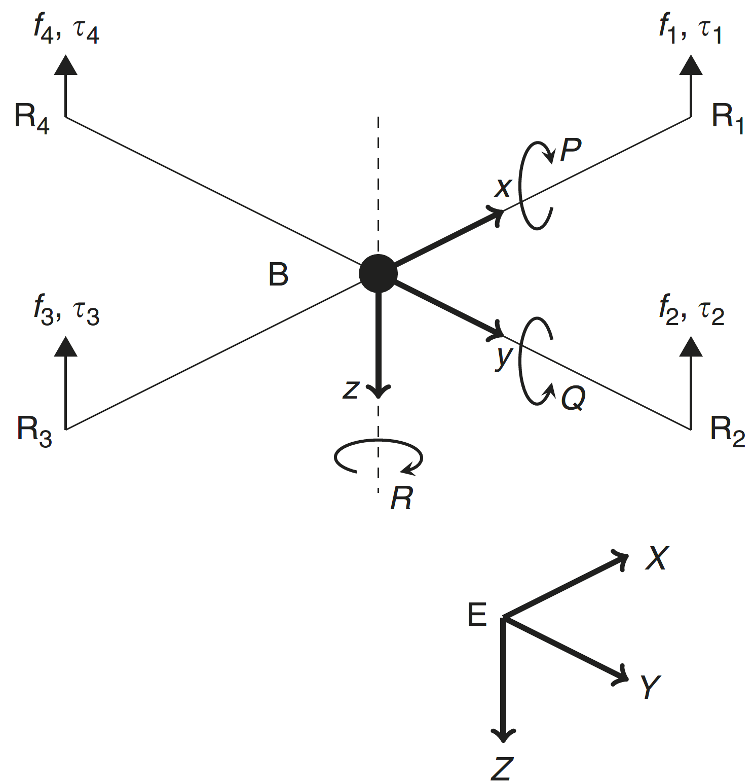
This paper presents a method for fault tolerant control of quadrotor UAVs in case of inversion of the torque direction, a situation that might occur due to structural, hardware or software issues. The proposed design is based on multiple-model ℒ1 adaptive control. The controller is composed of a nominal reference model and a set of degraded reference models. The nominal model is that with desired dynamics that are optimal regarding some specific criteria. In a degraded model, the performance criteria are reduced. It is designed to ensure system robustness in the presence of critical failures. The controller is tested in simulations and it is shown that the multiple model ℒ1 adaptive controller stabilizes the system in case of inversion of the control input, while the ℒ1 adaptive controller with a single nominal model fails.

ToufikSouanef
JamesWhidborne
AhseneBoubakir

Article

27 November 2023

Enhancing the Monitoring Protocols of Intermittent Flow Rivers with UAV-Based Optical Methods to Estimate the River Flow and Evaluate Their Environmental Status

Temporary streams are a key component of the hydrological cycle in arid and semi-arid regions, but their flow is highly variable and difficult to measure. In this paper, we present a novel approach that could be used to assess the flow of temporary streams this allowing to characterize their environmental status. Specifically, we apply the Image Velocimetry (IV) method to estimate surface velocity in temporary streams using Unmanned Aerial Vehicles (UAVs) equipped with optical sensors (IV-UAV method). The IV-UAV method enables the easy, safe and quick estimation of the velocity on the water’s surface. This method was applied in different temporary streams in Lesvos Island, Greece. The results obtained indicate that the IV-UAV can be implemented at low discharges, temporary streams and small streams. Specifically, the water depth ranged from 0.02 m to 0.28 m, while the channel width ranged from 0.6 m to 4.0 m. The estimated surface velocity ranged from 0.0 to 5.5 m/s; thus, the maximum water discharge was 0.60 m3/s for the largest monitored stream of the island. However, there were many occasions that measurements were unable due to various reasons such as dense vegetation or archaeological sites. Despite of this, the proposed methodology could be incorporated in optical protocols which are used to assess the environmental status of temporary streams of Mediterranean conditions. Finally, this would become a valuable tool for understanding the dynamics of these ecosystems and monitoring changes over time.

PaschalisKoutalakis
Mairi-DanaiStamataki
OuraniaTzoraki

Article

19 March 2024

Designing a Quadcopter for Fire and Temperature Detection with an Infrared Camera and PIR Sensor

In agriculture, medicine, and engineering, sudden fire outbreaks are prevalent. During such events, the ensuing fire spread is extensive and unpredictable, necessitating crucial data for effective response and control. To address this need, the current initiative focuses on utilizing an Unmanned Aerial Vehicle (UAV) with an Infrared (IR) sensor. This sensor detects and analyses temperature variations, accompanied by additional camera footage capturing thermal images to pinpoint the locations of the incidents precisely. The UAV’s programming is executed using Arduino-Nano and mission planner software, interfacing with the Pixhawk flight controller operating in a guided mode for autonomous navigation. The UAV configuration includes a radio module interfacing with Arduino-Nano, a flight controller, and remote-control functionality. The flight duration is approximately 10–15 min, contingent upon flight dynamics and environmental temperature. Throughout its airborne operation, the UAV transmits live telemetry and log feeds to the connected computer, displaying critical parameters such as altitude, temperature, battery status, vertical speed, and distance from the operator. The Pixhawk flight controller is specifically programmed to govern the UAV’s behavior, issuing warnings to the pilot in case of low voltage, prompting a timely landing to avert potential crashes. In case of in-flight instability or a crash, the mission planner can trace the UAV’s location, facilitating efficient recovery and minimizing costs and component availability losses. This integrated approach enhances situational awareness and mitigation strategies, offering a comprehensive solution for managing fire incidents in diverse fields.

Guruprasad Rathinakumar
EfstratiosL.Ntantis

Article

16 January 2024

A Position-based Hybrid Routing Protocol for Clustered Flying Ad Hoc Networks

Unmanned aerial vehicles (UAVs) have been used to establish flying ad hoc networks (FANETs) to support wireless communication in various scenarios, from disaster situations to wireless coverage extensions. However, the operation of FANETs faces mobility, wireless network variations and topology challenges. Conventional mobile ad hoc network and vehicular ad hoc network routing concepts have rarely been applied to FANETs, and even then they have produced unsatisfactory performance due to additional challenges not found in such networks. For instance, position-based routing protocols have been applied in FANET, but have failed to achieve adequate performance in large networks. Clustering solutions have also been used in large networks, but with a significant overhead in keeping track of the complete topology. Hence, to solve this problem, we propose a hybrid position-based segment-by-segment routing mechanism for clustered FANETs. This approach facilitates traffic engineering across multiple wireless clusters by combining position-based inter-cluster routing with a rank-based intra-cluster routing approach capable of balancing traffic loads between alternative cluster heads. Simulation results show that our solution achieves, on average, a lower power consumption of 72.5 J, a higher throughput of 275 Mbps and a much lower routing overhead of 17.5% when compared to other state-of-the-art end-to-end routing approaches.

Godwin Asaamoning
Paulo Mendes

News

Topic Collection

Distributed Theory in Applications of Autonomous Vehicles

Journal Issues All issues

TOP