Issue 1, Volume 2 – 5 articles

Cover Story (View full-size image):
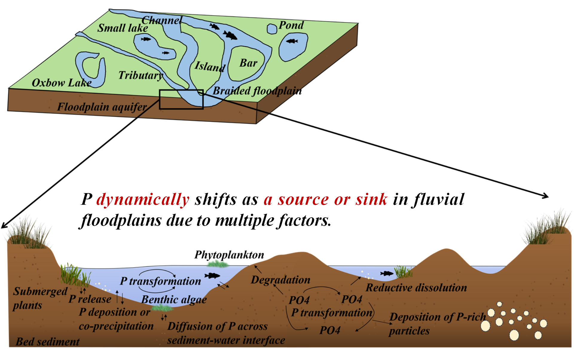
Fluvial floodplains are water-land transitional zones, playing an essential role in hydrological and ecological systems. This review summarises the sedimentary characteristics of floodplains and analyses the spatial and temporal variations of phosphorus in the sediment. We further explored their potential change in the river floodplains under various conditions, determining phosphorus sedimentation and mineralisation processes. Meanwhile, phosphorus will experience dynamic fluctuation as a source or sink of fluvial floodplains based on varying factors, including hydrological conditions, climate variations, biological activity, and pedological characteristics. In particular, the productivity and community population in floodplains, like vegetation and fish in the food chain, will be primarily associated with the periodic changes in phosphorus concentration. Lastly, this review provided corresponding perspectives on improving phosphorus administration in river floodplains based on existing problems. In total, it is anticipated that it will enhance the understanding of phosphorus resources or sinks in the fluvial floodplains, contributing to the stability of aquatic ecosystems.
View this paper

Review

14 January 2025

A Review of Phosphorous in Fluvial Floodplains: Source or Sink?

Fluvial floodplains are water-land transitional zones, playing an important role in hydrological and ecological systems. To date, the phosphorus migration and transformation in floodplain sediments remain elusive, which poses a large effect on river nutrient levels and primary productivity. This review summarized the sedimentary characteristics of floodplains and analyzed the spatial differences and temporal variations in phosphorus distribution. We further analyzed their potential change in floodplains under various conditions, determining the sedimentation and mineralization process of phosphorus. Meanwhile, phosphorus in the sediment will experience dynamic fluctuation as a source or sink of fluvial floodplains based on varying factors, including hydrological conditions, climate variations, biological activity, and pedological characteristics. In particular, the productivity and community population in floodplains, like vegetation and fishes, will be primarily associated with the periodic changes in phosphorus through food chain. Lastly, this review provided corresponding perspectives on improving the phosphorus administration in river floodplains based on existing problems. In total, it is anticipated that it will enhance the understanding of phosphorus resources or sink in the fluvial floodplains, contributing to the stability of aquatic ecosystems.

Article

06 February 2025

Performance Impacts of Rainwater Tanks on Stormwater Drainage Systems

This article explores the impact of using rainwater tanks on the performance of a stormwater drainage system and the possible challenges posed by climate change and future rainfall projections. This project examines a residential development in Aldinga, South Australia. The study sets clear research objectives that include the creation and simulation of drainage systems with different conditions (e.g., with and without rainwater tanks, historical data, and projected data). The aim is to analyze performance changes in the drainage network after the inclusion of rainwater tanks. Furthermore, the incorporation of projected rainfall data is considered to study possible implications of climate change on the system performance. The methodology follows a quantitative approach, with data collection, creating different models with the use of software, and simulating various conditions such as storms with different annual exceedance probabilities and varying proportions of roof area connected to rainwater tanks. Several findings are identified in this project. When roof areas of all residential allotments are connected to rainwater tanks, substantial benefits are observed in reducing peak flows within the network and runoff volumes. This proportion of connected roof area is directly correlated with reductions in peak flow. Also, while the use of projected rainfall data slightly affects benefits in peak flow and volume reduction, they will remain relatively high at least until 2050. Other performance features, such as hydraulic gradient line, long sections, and time to peak, are also explored. Study validates the hypothesis that rainwater tanks have a significant impact on runoff reductions and flood management, particularly when 100% of roof area is connected with rainwater tanks. Also, there is an impact when projected data is used, but it remains manageable and should be considered under specific contexts to decide whether these impacts are significant. Several opportunities for future research are suggested. These include the examination of larger areas, projections to a more distant future, the use of different rainfall patterns, and the consideration of extreme rainfall events.

Review

10 March 2025

A Review on Water Quality Indices

Water, as vital natural resource, is indispensable for human activities, both directly and indirectly. It significantly contributes to a country’s economic development, encompassing above-ground and underground water resources. However, ongoing pollution from surface contaminants is causing concerning degradation in both confined and unconfined aquifers, warranting the need for addressing this issue. Water quality indices (WQIs) serve this purpose by simplifying complex water quality data, providing a single value for easier interpretation. Surface water quality indices have achieved global recognition, while the development of groundwater quality indices is an evolving field. WQIs are established based on specific water quality criteria set by national and international organizations, which consider various parameters based on the intended use of water bodies. Consequently, numerous WQI models exist, including National Sanitation Foundation (NSFWQI), Oregon (OWQI), British Columbia (BCWQI), Canadian Council of Ministers of the Environments (CCMEWQI), and country-specific variants tailored to the unique requirements of individual regions such as Vietnam, India, Indonesia, Spain, Canada, Malaysia, and others, all in accordance with the specific characteristics of the water system under assessment.

Article

20 March 2025

Fluctuations in Internal Water Footprint of Major Crops in Egypt: Implications for Sustainable Water Management

The scarcity of water represents a significant obstacle to the advancement of agriculture in Egypt, requiring the implementation of inventive water policies and effective resource management practices. The notion of virtual water, which considers the water contained within things, is a possible remedy to mitigate the strain on water resources. This study examines the changes over time in the amount of water used internally and the amount of virtual water exported by rice, maize, and wheat crops in Egypt between 2000 and 2018. The assessment evaluates the impact of climate variables, crop productivity, and renewable water sources on the internal water footprint. The study uses data from several sources and applies a Nonlinear Autoregressive Distributed Lag (NARDL) model to analyse how productivity, renewable water supplies, temperature, and precipitation affect the internal water footprint. The EVIEWS software is utilised for conducting statistical analysis. The results demonstrate that the internal water footprint and productivity of the crops studied vary over time, and climate conditions and the availability of water control this variation. The maximum internal water footprint values for rice, maize, and wheat were recorded in 2008, 2011, and 2017, respectively, aligning with the highest temperatures and available renewable water resources. The analysis reveals complex connections between the independent factors and the internal water footprint of each crop. Precipitation has an inverse correlation with the internal water footprint of rice, but renewable water resources have a favourable impact on the internal water footprint of wheat. The study emphasizes improving crop choices to minimize water usage and boost water output. Given Egypt’s expected water scarcity by 2025 and its reliance on Nile water for irrigation, implementing sustainable solutions for water resource management in agriculture is crucial. These findings give useful insights for policymakers and stakeholders in creating efficient water management policies and promoting food security in Egypt.

Article

25 March 2025

Integrated Habitat Assessment of a Protected Fish Species in the Upper Yangtze River, China: Connectivity and Suitability

In the context of anthropogenic climate change, dam construction, and other human activities, the biodiversity of freshwater fish is rapidly declining. The Upper Yangtze River Basin (UYRB) is a hotspot for hydropower development and is home to numerous endemic and rare freshwater fish species, most of which are on the brink of extinction. Schizothorax chongi is an endangered and protected fish species endemic to the UYRB, with significant economic and ecological value. However, the potential habitat of its wild population has not been reported, which hampers conservation efforts for this valuable species. This study utilized the Dendritic Connection Index (DCI) and Species Distribution Models (SDMs) to assess habitat connectivity in the UYRB and habitat suitability for S. chongi during the periods 1970–2000 and 2001–2020, respectively. The results show that S. chongi habitats underwent significant reduction during the 2001–2020 period, with the total length of medium and high suitability habitats decreasing by 51.7%. However, high suitability habitats in the southern section of the middle and lower Jinsha River, which is located in the upper and middle part of the UYRB, did not experience a noticeable reduction. Despite the relatively high habitat suitability maintained in the southern section of the middle and lower Jinsha River, connectivity has significantly declined. Restoring connectivity reduced by dam construction in this region is critically urgent. This study is the first to conduct a watershed-scale assessment of fish habitat integrating habitat suitability and connectivity providing valuable insights for local governments to develop specific conservation measures and plans. It can offer a valuable reference for researchers in the field of freshwater fish conservation.

TOP