ISSN: 3007-5319 (Online)
3007-5300 (Print)
In Greek waters, the spottail mantis shrimp Squilla mantis (Linnaeus, 1758) presents significant ecological and low to moderate economic value. This study investigates the population dynamics and stock assessment of the species in the north Aegean Sea. A total of 856 individuals were collected using commercial bottom trawls between April 2021 and April 2023. Key population parameters such as size distribution, sex ratio, growth, size at maturity and spawning seasonality were assessed. Results indicate a relatively stable population with a slight male dominance and peak spawning activity occurring in late spring to early summer. Growth parameters were estimated using the von Bertalanffy growth model, revealing moderate growth rates and a maximum length slightly higher than previously recorded for this species in other Mediterranean regions. Stock assessment, conducted through yield-per-recruit analysis, suggests that the current exploitation levels are approaching sustainable limits. However, potential overfishing risks necessitate continuous monitoring and the implementation of adaptive management strategies. This study underscores the importance of integrative approaches combining biological and fisheries data to ensure the sustainable management of S. mantis populations in the Aegean Sea.
Accurately estimating flood levels is essential for effective infrastructure design, reservoir management, and flood risk mapping. Traditional methods for predicting these levels often rely on annual maximum flood (AMF) data, which may not always fit well to statistical models. To improve these estimates, we tested an approach that considers floods in relation to annual climate conditions—specifically, average, wet, and dry years—using daily streamflow data. We examined how well the Log Pearson Type III (LP3) distribution, a commonly used statistical model in flood frequency analysis, estimates flood levels when applied to these customized datasets instead of standard AMF data. Our study included over 70 years of data from 2028 basins across the United States, with drainage areas ranging from small (4.0 km2) to large (50,362 km2). We found that in some regions, LP3 better estimated frequent floods (recurrence interval of 2 to 25 years) when applied to AMF data. However, for less frequent, larger floods (recurrence interval of 50 to 200 years), the LP3 model worked better when applied to datasets representing wet or dry years. This approach could lead to more reliable flood predictions, which would benefit infrastructure planning and flood preparedness efforts.
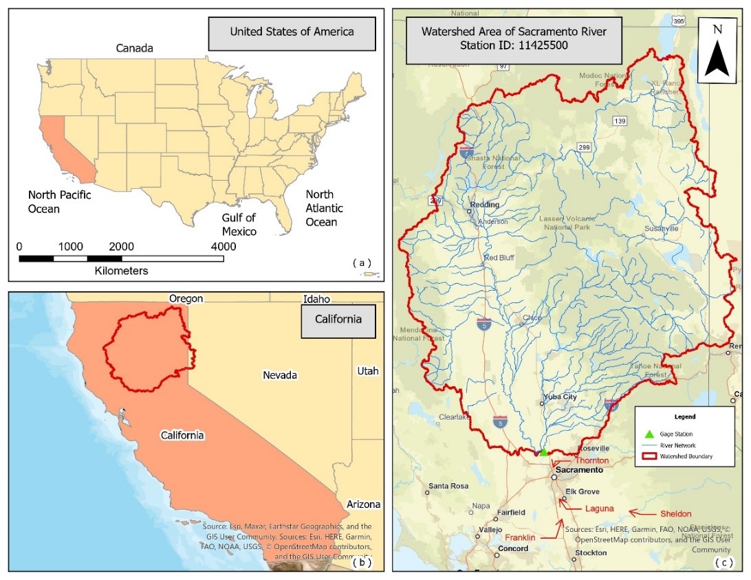
Climate change is leading to rapid environmental changes, including fluctuating precipitation and water levels, which raises the risk of flooding in coastal and riverine locations around the United States. This study focuses on Sacramento, California, a city significantly affected by these changes and recent severe flooding disasters. The ultimate goal is to understand the climate dynamics and create a more robust model to alert Sacramento and other communities to possible flooding and better prepare them for future climatic uncertainty. In this research, four classification machine learning models—Support Vector Machine (SVM), Random Forest (RF), Artificial Neural Network (ANN), and Long Short-Term Memory (LSTM)—are examined for their capacity to predict the occurrence of floods using historical precipitation temperature and soil moisture data. Our results demonstrate that the LSTM model, with an accuracy of 89.99%, may provide better reliable flood predictions, possibly due to its ability to process complicated temporal data. SVM, RF, and ANN showed accuracies of 81.25%, 83.75%, and 85%, respectively. The study explores the correlation between increasing precipitation incidents and severe climate variations, such as the El Niño and La Niña cycles, which could have increased flooding risks. Significant rainfall peaks occurred in 1998 and 2007, indicating that external atmospheric circumstances might have considerably impacted local weather patterns. While LSTM models show potential, there remains room to improve their accuracy and adaptability in extreme flood scenarios. Given these findings, future research could combine multiple environmental data sources and hybrid modeling approaches to enhance predictions.
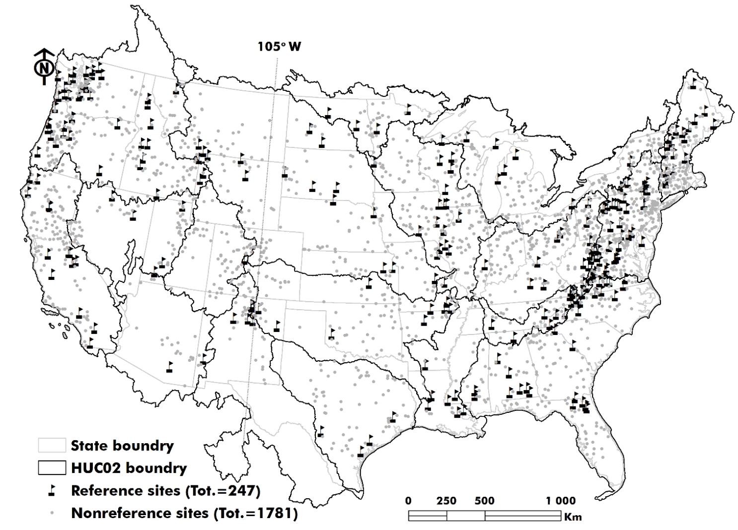
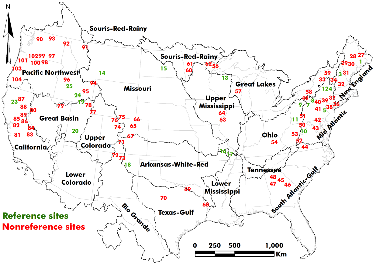
Nonstationarity due to climate variation and anthropogenic disturbances has altered high flow regimes. However, the extent of change has not been evaluated for undisturbed versus disturbed watersheds. This article aimed to determine how partitioning watersheds into undisturbed and disturbed categories can improve the performance of probability distributions for flood analysis throughout the United States. We utilized peak flow information for 26 reference (undisturbed) and 78 nonreference (disturbed) watersheds with drainage areas ranging from 135 to 42,367 km2 and record lengths of 100 to 140 years. Results indicated that flood quantile estimates of the Log Pearson Type III (LP3) distribution were likely being overestimated for return periods of 2 to 10 years, while flood estimates of 50 years and higher might be underestimated. In contrast, the Generalized Extreme Value (GEV) distribution outperformed LP3 in estimating floods with return periods of 50 years or more. These findings enhance flood frequency analysis and forecasting under nonstationary conditions.
Climate change is leading to rapid environmental changes, including fluctuating precipitation and water levels, which raises the risk of flooding in coastal and riverine locations around the United States. This study focuses on Sacramento, California, a city significantly affected by these changes and recent severe flooding disasters. The ultimate goal is to understand the climate dynamics and create a more robust model to alert Sacramento and other communities to possible flooding and better prepare them for future climatic uncertainty. In this research, four classification machine learning models—Support Vector Machine (SVM), Random Forest (RF), Artificial Neural Network (ANN), and Long Short-Term Memory (LSTM)—are examined for their capacity to predict the occurrence of floods using historical precipitation temperature and soil moisture data. Our results demonstrate that the LSTM model, with an accuracy of 89.99%, may provide better reliable flood predictions, possibly due to its ability to process complicated temporal data. SVM, RF, and ANN showed accuracies of 81.25%, 83.75%, and 85%, respectively. The study explores the correlation between increasing precipitation incidents and severe climate variations, such as the El Niño and La Niña cycles, which could have increased flooding risks. Significant rainfall peaks occurred in 1998 and 2007, indicating that external atmospheric circumstances might have considerably impacted local weather patterns. While LSTM models show potential, there remains room to improve their accuracy and adaptability in extreme flood scenarios. Given these findings, future research could combine multiple environmental data sources and hybrid modeling approaches to enhance predictions.
Accurately estimating flood levels is essential for effective infrastructure design, reservoir management, and flood risk mapping. Traditional methods for predicting these levels often rely on annual maximum flood (AMF) data, which may not always fit well to statistical models. To improve these estimates, we tested an approach that considers floods in relation to annual climate conditions—specifically, average, wet, and dry years—using daily streamflow data. We examined how well the Log Pearson Type III (LP3) distribution, a commonly used statistical model in flood frequency analysis, estimates flood levels when applied to these customized datasets instead of standard AMF data. Our study included over 70 years of data from 2028 basins across the United States, with drainage areas ranging from small (4.0 km2) to large (50,362 km2). We found that in some regions, LP3 better estimated frequent floods (recurrence interval of 2 to 25 years) when applied to AMF data. However, for less frequent, larger floods (recurrence interval of 50 to 200 years), the LP3 model worked better when applied to datasets representing wet or dry years. This approach could lead to more reliable flood predictions, which would benefit infrastructure planning and flood preparedness efforts.
In Greek waters, the spottail mantis shrimp Squilla mantis (Linnaeus, 1758) presents significant ecological and low to moderate economic value. This study investigates the population dynamics and stock assessment of the species in the north Aegean Sea. A total of 856 individuals were collected using commercial bottom trawls between April 2021 and April 2023. Key population parameters such as size distribution, sex ratio, growth, size at maturity and spawning seasonality were assessed. Results indicate a relatively stable population with a slight male dominance and peak spawning activity occurring in late spring to early summer. Growth parameters were estimated using the von Bertalanffy growth model, revealing moderate growth rates and a maximum length slightly higher than previously recorded for this species in other Mediterranean regions. Stock assessment, conducted through yield-per-recruit analysis, suggests that the current exploitation levels are approaching sustainable limits. However, potential overfishing risks necessitate continuous monitoring and the implementation of adaptive management strategies. This study underscores the importance of integrative approaches combining biological and fisheries data to ensure the sustainable management of S. mantis populations in the Aegean Sea.
Climate change is leading to rapid environmental changes, including fluctuating precipitation and water levels, which raises the risk of flooding in coastal and riverine locations around the United States. This study focuses on Sacramento, California, a city significantly affected by these changes and recent severe flooding disasters. The ultimate goal is to understand the climate dynamics and create a more robust model to alert Sacramento and other communities to possible flooding and better prepare them for future climatic uncertainty. In this research, four classification machine learning models—Support Vector Machine (SVM), Random Forest (RF), Artificial Neural Network (ANN), and Long Short-Term Memory (LSTM)—are examined for their capacity to predict the occurrence of floods using historical precipitation temperature and soil moisture data. Our results demonstrate that the LSTM model, with an accuracy of 89.99%, may provide better reliable flood predictions, possibly due to its ability to process complicated temporal data. SVM, RF, and ANN showed accuracies of 81.25%, 83.75%, and 85%, respectively. The study explores the correlation between increasing precipitation incidents and severe climate variations, such as the El Niño and La Niña cycles, which could have increased flooding risks. Significant rainfall peaks occurred in 1998 and 2007, indicating that external atmospheric circumstances might have considerably impacted local weather patterns. While LSTM models show potential, there remains room to improve their accuracy and adaptability in extreme flood scenarios. Given these findings, future research could combine multiple environmental data sources and hybrid modeling approaches to enhance predictions.utf-8
Nonstationarity due to climate variation and anthropogenic disturbances has altered high flow regimes. However, the extent of change has not been evaluated for undisturbed versus disturbed watersheds. This article aimed to determine how partitioning watersheds into undisturbed and disturbed categories can improve the performance of probability distributions for flood analysis throughout the United States. We utilized peak flow information for 26 reference (undisturbed) and 78 nonreference (disturbed) watersheds with drainage areas ranging from 135 to 42,367 km2 and record lengths of 100 to 140 years. Results indicated that flood quantile estimates of the Log Pearson Type III (LP3) distribution were likely being overestimated for return periods of 2 to 10 years, while flood estimates of 50 years and higher might be underestimated. In contrast, the Generalized Extreme Value (GEV) distribution outperformed LP3 in estimating floods with return periods of 50 years or more. These findings enhance flood frequency analysis and forecasting under nonstationary conditions.utf-8
Accurately estimating flood levels is essential for effective infrastructure design, reservoir management, and flood risk mapping. Traditional methods for predicting these levels often rely on annual maximum flood (AMF) data, which may not always fit well to statistical models. To improve these estimates, we tested an approach that considers floods in relation to annual climate conditions—specifically, average, wet, and dry years—using daily streamflow data. We examined how well the Log Pearson Type III (LP3) distribution, a commonly used statistical model in flood frequency analysis, estimates flood levels when applied to these customized datasets instead of standard AMF data. Our study included over 70 years of data from 2028 basins across the United States, with drainage areas ranging from small (4.0 km2) to large (50,362 km2). We found that in some regions, LP3 better estimated frequent floods (recurrence interval of 2 to 25 years) when applied to AMF data. However, for less frequent, larger floods (recurrence interval of 50 to 200 years), the LP3 model worked better when applied to datasets representing wet or dry years. This approach could lead to more reliable flood predictions, which would benefit infrastructure planning and flood preparedness efforts.utf-8
In Greek waters, the spottail mantis shrimp Squilla mantis (Linnaeus, 1758) presents significant ecological and low to moderate economic value. This study investigates the population dynamics and stock assessment of the species in the north Aegean Sea. A total of 856 individuals were collected using commercial bottom trawls between April 2021 and April 2023. Key population parameters such as size distribution, sex ratio, growth, size at maturity and spawning seasonality were assessed. Results indicate a relatively stable population with a slight male dominance and peak spawning activity occurring in late spring to early summer. Growth parameters were estimated using the von Bertalanffy growth model, revealing moderate growth rates and a maximum length slightly higher than previously recorded for this species in other Mediterranean regions. Stock assessment, conducted through yield-per-recruit analysis, suggests that the current exploitation levels are approaching sustainable limits. However, potential overfishing risks necessitate continuous monitoring and the implementation of adaptive management strategies. This study underscores the importance of integrative approaches combining biological and fisheries data to ensure the sustainable management of S. mantis populations in the Aegean Sea.utf-8